
WEATHER.COM.PH TROPICAL CYCLONE UPDATES
TROPICAL STORM RUMBIA (GORIO) UPDATE NUMBER 004
Issued: 1:00 PM PhT (05:00 GMT) Saturday 29 June 2013
Next Update: 7:00 PM PhT (11:00 GMT) Saturday 29 June 2013
Tropical Storm RUMBIA (GORIO) now passing near Calbayog City in Western Samar after making landfall just north of Borongan City this morning...expected to pass along the western shoreline of Bicol Region (Albay-Sorsogon-Camarines Sur Area) late this afternoon through the evening. Heavy rains continues to pour across most parts of the Bicol Region & Eastern Visayas.
This storm will enhance the Southwest Monsoon (Hanging Habagat) and bring windy/cloudy conditions with occasionally slight to moderate to sometimes heavy rains and thunderstorms across Palawan, Western Mindanao and Western Visayas today.
Residents and visitors along Eastern Visayas, Bicol and Luzon including Metro Manila should closely monitor the development of RUMBIA (GORIO).
Do not use this for life or death decision. This update is intended for additional information purposes only. Kindly refer to your national weather agency for official warnings, advisories or bulletins.
CURRENT STORM ANALYSIS
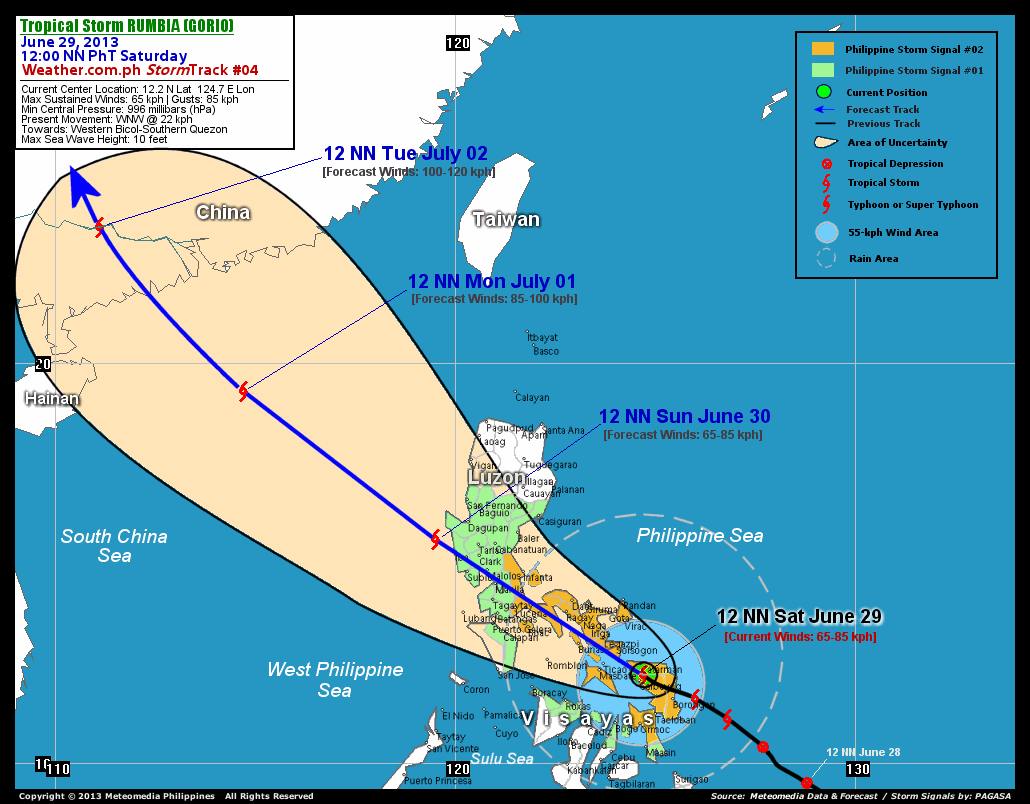
As of 12:00 noon today, the center of TS Rumbia (Gorio) was located over land, along the boundary of Western and Northern Samar...about 16 km northeast of Calbayog City, Western Samar or 35 km south of Catarman, Northern Samar...currently moving west-northwest with an decreased forward speed of 22 km/hr in the general direction of Western Bicol and Southern Quezon.
Maximum Sustained Winds (1-min. avg) remains at 65 km/hr near the center with higher gusts. Rumbia (Gorio) is an average-sized tropical cyclone with a diameter of 335 kilometers across. The 24-hour rainfall accumulation near the center of Rumbia (Gorio) is estimated to be extreme (320 mm).
3-DAY FORECAST OUTLOOK*
TS Rumbia (Gorio) is expected to resume moving northwestward throughout the forecast period. On the forecast track, the core of Rumbia (Gorio) will traverse Ragay Gulf and pass along the western shoreline of Sorsogon-Albay-Camarines Sur this afternoon through the evening...and will be crossing Bondoc Peninsula in Southern Quezon around midnight on Sunday. Rumbia will then be passing over or very close to Metro Manila on Sunday morning approx. between 5:00 to 8:00 am...and exit Western Luzon via Iba, Zambales before Sunday noon. By Sunday afternoon, the storm will be over the West Philippine Sea...and exit the Philippine Area of Responsibility (PAR) by early morning Monday. Tuesday early morning, the storm will be making landfall over Southern China (Western Guangdong Area).
Rumbia (Gorio) is forecast to maintain its strength for the next 12 to 24 hours...but will start to intensify during the next 24 to 48 hours as the system moves back over to sea.
The following is the summary of the 3-day forecast outlook on this system:
 SUNDAY NOON: Off the west coast of Zambales...about 63 km west-northwest of Iba, Zambales [12PM JUNE 30: 15.6N 119.5E @ 65kph].
MONDAY NOON: Over the South China Sea...outside of PAR...about 338 km south-southeast of Hong Kong [12PM JULY 01: 19.3N 114.7E @ 85kph].
TUESDAY NOON: Makes landfall over Western Guangdong, China...about 289 km west-northwest of Macau [12PM JULY 02: 23.4N 111.1E @ 100kph].
*Please be reminded that the Forecast Outlook changes every 6 hours, and the Day 3 Forecast Track have an average error of 250 km...while the wind speed forecast error, averages 35 kph per day. Therefore, a turn to the left or right of its future track and changes in its wind speed must be anticipated from time to time.
EFFECTS & HAZARDS SUMMARY
Below is the summary of the storm's parts and its hazards affecting specific areas. You can also view this image link for you to understand the parts.
INNER RAINBANDS - spreading across Eastern Visayas and Southern Bicol. Affected Areas Samar and Leyte Provinces, Ticao Island, Masbate, and Sorsogon: None. Tropical Storm Conditions with Tropical Storm Force Winds (63-85 kph) will be expected along these bands. OUTER RAINBANDS - spreading across Southern Luzon, the rest of Northern Visayas and Bicol Region. Affected Areas: CaLaBaRZon, Romblon, Marinduque, Panay, Northern Negros, Northern Cebu and the rest of Bicol Region. Tropical Depression Conditions with light, moderate to strong winds (30-62 kph) will be expected along these bands (click here to know more about Rainbands). 24HR TOTAL RAINFALL ACCUMULATION - from 5 up to 100 mm (slight to heavy rainfall) can be expected along areas affected by the outer & inner rainbands (see above)...with isolated amounts of 101 to 320 mm (heavy to extreme) along areas to the west, north and near the center of Rumbia (Gorio).
Important Note: Please keep in mind that the above forecast outlook, effects and hazards summary changes every 6 to 12 hrs!
CURRENT TECHNICAL INFORMATION
Time/Date: 12:00 NN PhT Sat June 29, 2013
Class/Name: TS Rumbia (Gorio)
Location of Center: 12.2º N Lat 124.7º E Lon
Distance 1: 16 km NE of Calbayog City
Distance 2: 35 km S of Catarman, Northern Samar
Distance 3: 101 km NW of Borongan City
Distance 4: 114 km ESE of Ticao Island
Distance 5: 120 km ESE of Masbate City
Distance 6: 124 km SSE of Sorsogon City
Distance 7: 148 km SSE of Legazpi City
Distance 8: 165 km SSE of Virac, Catanduanes
Distance 9: 225 km SE of Metro Naga
Distance 10: 472 km SE of Metro Manila
MaxWinds (1-min avg): 65 kph near the center
Peak Wind Gusts: 85 kph
Present Movement: WNW @ 22 kph
Towards: Western Bicol and Southern Quezon
24hr Rainfall Accum (near center): Extreme [320 mm]
Minimum Central Pressure: 996 millibars (hPa)
Size (in Diameter): 335 km [Average]
Max Sea Wave Height (near center): 10 feet
Possible Storm Surge Height: 0 ft (0 m)
T2K/WP StormTracks (for Public): GIF | Google Map (Flash)

CURRENT NOAA/MTSAT-2 INFRARED (IR) SATELLITE IMAGE:

CURRENT TRACKING MAP:
 _____________________________________________________________________________
>> To know the meteorological terminologies and acronyms used on this update visit the ff:
http://typhoon2000.ph/tcterm.htm
http://www.nhc.noaa.gov/aboutgloss.shtml
http://www.nhc.noaa.gov/acronyms.shtml
__________________________________________________________________________________________
For the complete details on TS RUMBIA (GORIO)...go visit our website @:
> http://www.typhoon2000.com
> http://www.maybagyo.com
<<<Typhoon2000.com Mobile >>>
Get the latest SMS Storm Alerts!
For more details: Text T2K TYPHOON to
2800 (Globe/TM) | Offline (Smart/TNT) | 2288 (Sun)
*Only P2.50 (Smart/Globe) / P2.00 (Sun) per msg received.
Click here on how to use this service (in PDF file)
Powered by: Synermaxx Corporation
Copyright © 2013 Typhoon2000.com All Rights Reserved
| Reply via web post | Reply to sender | Reply to group | Start a New Topic | Messages in this topic (1) |

No comments:
Post a Comment