
WEATHER.COM.PH TROPICAL CYCLONE UPDATES
TROPICAL STORM BEBINCA (FABIAN) UPDATE NUMBER 004
Issued: 7:00 PM PhT (11:00 GMT) Friday 21 June 2013
Next Update: 7:00 AM PhT (23:00 GMT) Saturday 22 June 2013
05W (FABIAN) becomes a Tropical Storm (TS)...now internationally named "Bebinca" - a milk pudding in Macau...threatens the Southwestern part of Guangdong Province and the northern part of Hainan Island.
This storm will continue to enhance the Southwest Monsoon (Hanging Habagat) and bring windy/cloudy conditions with occasionally slight to moderate to sometimes heavy rains and thunderstorms across Palawan and Spratly Islands.
Residents and visitors along Southwestern Guangdong and Hainan Island should closely monitor the development of BEBINCA (FABIAN).
Do not use this for life or death decision. This update is intended for additional information purposes only. Kindly refer to your national weather agency for official warnings, advisories or bulletins.
CURRENT STORM ANALYSIS
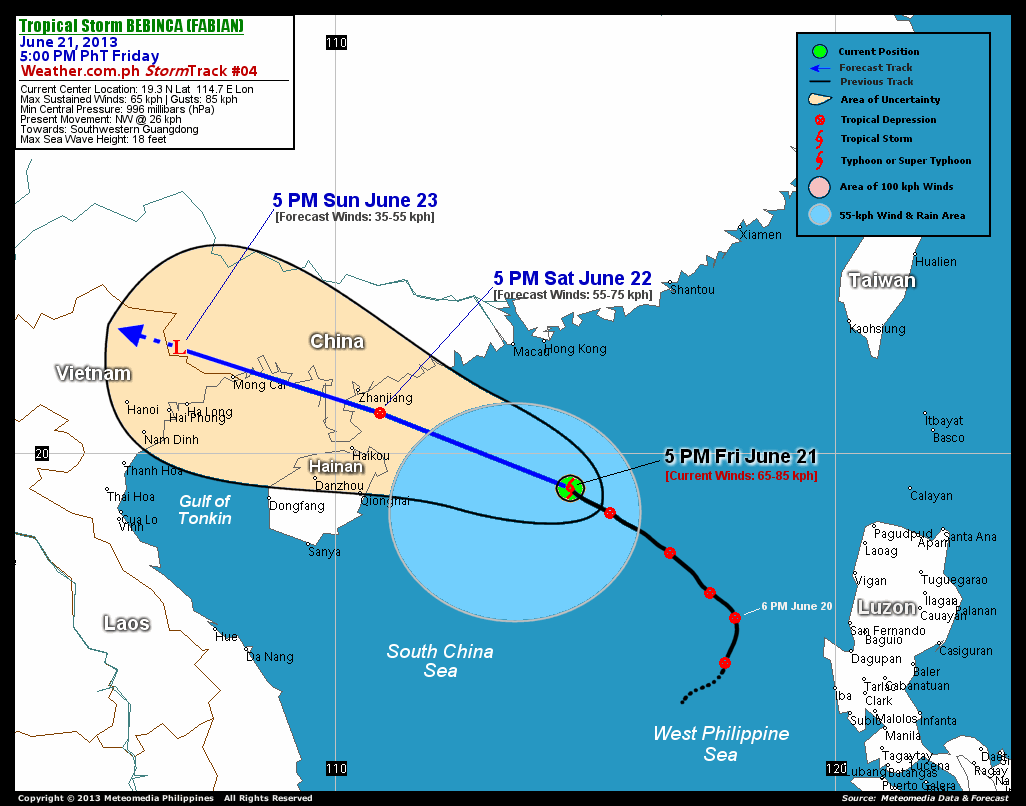
As of 5:00 pm today, the center of TS Bebinca (Fabian) was located over the South China Sea...about 327 km south-southeast of Hong Kong or 441 km east of Qionghai, Hainan Island...currently moving northwest with an increased forward speed of 26 km/hr in the general direction of Southwestern Guangdong and the northern part of Hainan Island.
Maximum Sustained Winds (1-min. avg) have increased to 65 km/hr near the center with higher gusts. Bebinca (Fabian) is an average-sized tropical cyclone with a diameter of 500 kilometers across. The 24-hour rainfall accumulation near the center of Bebinca (Fabian) is estimated to be extreme (500 mm).
2-DAY FORECAST OUTLOOK*
TS Bebinca (Fabian) is expected to move northwest to west-northwestward throughout the forecast period. On the forecast track, the core of Bebinca (Fabian) will remain over the South China Sea until Saturday noon...and will approach the coastal areas of Southwestern Guangdong and Northern Hainan on Saturday afternoon...making landfall just to the southwest of Zhanjiang City Saturday evening. By Sunday afternoon, the storm could be over the Vietnamese-Chinese border.
Bebinca (Fabian) is forecast to maintain strength during the next 12 to 18 hours...and could weaken into a Tropical Depression (TD) on or before landfall Saturday afternoon or evening. This storm will just be an area of low pressure on Sunday afternoon.
The following is the summary of the 2-day forecast outlook on this system:
 SATURDAY AFTERNOON: Weakens to a TD as it prepares to make landfall over Southewestern Guangdong...about 69 km southeast of Zhanjiang City [5PM JUNE 22: 20.8N 110.9E @ 55kph].
SUNDAY AFTERNOON: Just an area of low pressure along the Chinese-Vietnamese border...about 132 km WNW of Mong Cai, Vietnam [5PM JUNE 23: 22.1N 106.9E @ 35kph].
*Please be reminded that the Forecast Outlook changes every 6 hours, and the Day 3 Forecast Track have an average error of 250 km...while the wind speed forecast error, averages 35 kph per day. Therefore, a turn to the left or right of its future track and changes in its wind speed must be anticipated from time to time.
EFFECTS & HAZARDS SUMMARY
Below is the summary of the storm's parts and its hazards affecting specific areas. You can also view this image link for you to understand the parts.
INNER RAINBANDS - spreading over the South China Sea. Affected Areas: None. Tropical Storm Conditions with Tropical Storm Force Winds (63-85 kph) will be expected along these bands. OUTER RAINBANDS - spreading across the South China Sea. Affected Areas: Eastern Hainan. Tropical Depression Conditions with light, moderate to strong winds (30-62 kph) will be expected along these bands (click here to know more about Rainbands). 24HR TOTAL RAINFALL ACCUMULATION - from 5 up to 200 mm (slight to heavy rainfall) can be expected along areas affected by the outer & inner rainbands (see above)...with isolated amounts of 201 to 500 mm (heavy to extreme) along areas to the south, west and near the center of Bebinca (Fabian).
Important Note: Please keep in mind that the above forecast outlook, effects and hazards summary changes every 6 to 12 hrs!
CURRENT TECHNICAL INFORMATION
Time/Date: 5:00 PM PhT Fri June 21, 2013
Class/Name: TS Bebinca (Fabian)
Location of Center: 19.3º N Lat 114.7º E Lon
Distance 1: 327 km SSE of Hong Kong
Distance 2: 342 km SSE of Macau
Distance 3: 441 km E of Qionghai, Hainan
Distance 4: 469 km ESE of Haikou, Hainan
Distance 5: 491 km SE of Zhanjiang, China
Distance 6: 633 km WNW of Laoag City
MaxWinds (1-min avg): 65 kph near the center
Peak Wind Gusts: 85 kph
Present Movement: NW @ 26 kph
Towards: Southwestern Guangdong
24hr Rainfall Accum (near center): Extreme [500 mm]
Minimum Central Pressure: 996 millibars (hPa)
Size (in Diameter): 500 km [Average]
Max Sea Wave Height (near center): 18 feet
Possible Storm Surge Height: 0 ft (0 m)
T2K/WP StormTracks (for Public): GIF | Google Map (Flash)

CURRENT NOAA/MTSAT-2 INFRARED (IR) SATELLITE IMAGE:

CURRENT TRACKING MAP:
 _____________________________________________________________________________
>> To know the meteorological terminologies and acronyms used on this update visit the ff:
http://typhoon2000.ph/tcterm.htm
http://www.nhc.noaa.gov/aboutgloss.shtml
http://www.nhc.noaa.gov/acronyms.shtml
__________________________________________________________________________________________
For the complete details on TS BEBINCA (FABIAN)...go visit our website @:
> http://www.typhoon2000.com
> http://www.maybagyo.com
<<<Typhoon2000.com Mobile >>>
Get the latest SMS Storm Alerts!
For more details: Text T2K TYPHOON to
2800 (Globe/TM) | Offline (Smart/TNT) | 2288 (Sun)
*Only P2.50 (Smart/Globe) / P2.00 (Sun) per msg received.
Click here on how to use this service (in PDF file)
Powered by: Synermaxx Corporation
Copyright © 2013 Typhoon2000.com All Rights Reserved
| Reply via web post | Reply to sender | Reply to group | Start a New Topic | Messages in this topic (1) |

No comments:
Post a Comment