
WEATHER.COM.PH TROPICAL CYCLONE UPDATES
TROPICAL DEPRESSION 04W (EMONG) UPDATE NUMBER 002
Issued: 7:00 AM PhT (23:00 GMT) Tuesday 18 June 2013
Next Update: 1:00 PM PhT (05:00 GMT) Tuesday 18 June 2013
Tropical Depression 04W [EMONG] has slightly accelerated northward while over intensifying over the Philippine Sea.
This depression is likely to enhance the Southwest Monsoon (Hanging Habagat) and bring windy/cloudy conditions with occasional rains and thunderstorms across Metro Manila, MiMaRoPa, CaLaBaRZON, Western Luzon incl. Western Bicol beginning Tuesday night or early Wednesday.
Residents and visitors along the east coast of Central and Northern Luzon should closely monitor the development of 04W (EMONG).
Do not use this for life or death decision. This update is intended for additional information purposes only. Kindly refer to your national weather agency for official warnings, advisories or bulletins.
CURRENT STORM ANALYSIS
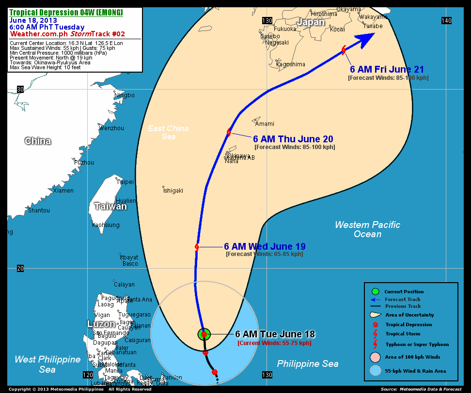
As of 6:00 am today, the center of Tropical Depression 04W (Emong) was located over the Philippine Sea...about 470 km east of Casiguran, Aurora or 504 km northeast of Polillo Island...currently moving north with a forward speed of 19 km/hr in the general direction of Okinawa-Ryukyu Islands Area.
Maximum Sustained Winds (1-min. avg) have increased to 55 km/hr near the center with higher gusts. The 24-hour rainfall accumulation near the center of 04W (Emong) is estimated to be heavy (250 mm).
3-DAY FORECAST OUTLOOK*
TD 04W (Emong) is expected to accelerate more to the north-northeast during the next 24 to 48 hours...with a turn to the northeast by 72 hours. On the forecast track, the core of 04W (Emong) will be just along the open waters of the North Philippine Sea through Wednesday evening and exit the Philippine Area of Responsibility (PAR). It could pass very close to Okinawa and the Ryukyu Islands on Thursday morning...and pass near the coast Shikoku, Japan on Friday morning.
04W (Emong) is forecast to slowly intensify during the next 24 hours...becoming a Tropical Storm on Wednesday morning...and will continue to gain strength throughout the forecast period, reaching a peak of 85 kph between Thursday and Friday.
The following is the summary of the 3-day forecast outlook on this system:
 WEDNESDAY MORNING: Accelerating north to north-northeast across the open waters of the North Philippine Sea...about 433 km east-northeast of Basco, Batanes [6AM JUNE 19: 21.2N 126.1E @ 65kph].
THURSDAY MORNING: Passing close to Okinawa-Ryukyu Islands...about 123 km north of Okinawa, Japan [6AM JUNE 20: 27.6N 127.9E @ 85kph].
FRIDAY MORNING: Passing near the coast of Southern Shikoku...about 163 km south-southeast of Kochi, Japan [6AM JUNE 21: 32.2N 134.3E @ 85kph].
EFFECTS & HAZARDS SUMMARY
Below is the summary of the storm's parts and its hazards affecting specific areas. You can also view this image link for you to understand the parts.
DEVELOPING RAINBANDS - over water (Philippine Sea). Affected Areas: East Coast of Catanduanes Tropical Depression Conditions with light, moderate to strong winds (30-60 kph) will be expected along these bands (click here to know more about Rainbands). 24HR TOTAL RAINFALL ACCUMULATION - from 5 up to 50 mm (slight to moderate rainfall) can be expected along areas affected by the rainbands (see above)...with isolated amounts of 51 to 250 mm (moderate to heavy) along areas near the center of 04W (Emong).
Important Note: Please keep in mind that the above forecast outlook, effects and hazards summary changes every 6 to 12 hrs!
CURRENT TECHNICAL INFORMATION
Time/Date: 6:00 AM PhT Tue June 18, 2013
Class/Name: TD 04W (Emong)
Location of Center: 16.3º N Lat 126.5º E Lon
Distance 1: 347 km NNE of Pandan, Catanduanes
Distance 2: 402 km NNE of Caramoan, CamSur
Distance 3: 444 km ESE of Palanan, Isabela
Distance 4: 457 km NE of Daet, CamNorte
Distance 5: 458 km NNE of Legazpi City
Distance 6: 464 km NNE of Metro Naga
Distance 7: 470 km E of Casiguran, Aurora
Distance 8: 504 km NE of Polillo Island
Distance 9: 531 km SE of Tuguegarao City
Distance 10: 609 km NE of Metro Manila
MaxWinds (1-min avg): 55 kph near the center
Peak Wind Gusts: 75 kph
Present Movement: North @ 19 kph
Towards: Okinawa-Ryukyu Islands
24hr Rainfall Accum (near center): Heavy [250 mm]
Minimum Central Pressure: 1000 millibars (hPa)
Max Sea Wave Height (near center): 10 feet
Possible Storm Surge Height: 0 ft (0 m)
T2K/WP StormTracks (for Public): GIF | Google Map (Flash)

CURRENT NOAA/MTSAT-2 INFRARED (IR) SATELLITE IMAGE:

CURRENT TRACKING MAP:
 _____________________________________________________________________________
>> To know the meteorological terminologies and acronyms used on this update visit the ff:
http://typhoon2000.ph/tcterm.htm
http://www.nhc.noaa.gov/aboutgloss.shtml
http://www.nhc.noaa.gov/acronyms.shtml
__________________________________________________________________________________________
For the complete details on TD 04W (EMONG)...go visit our website @:
> http://www.typhoon2000.com
> http://www.maybagyo.com
<<<Typhoon2000.com Mobile >>>
Get the latest SMS Storm Alerts!
For more details: Text T2K TYPHOON to
2800 (Globe/TM) | Offline (Smart/TNT) | 2288 (Sun)
*Only P2.50 (Smart/Globe) / P2.00 (Sun) per msg received.
Click here on how to use this service (in PDF file)
Powered by: Synermaxx Corporation
Copyright © 2013 Typhoon2000.com All Rights Reserved
| Reply via web post | Reply to sender | Reply to group | Start a New Topic | Messages in this topic (1) |

No comments:
Post a Comment