
WEATHER.COM.PH TROPICAL CYCLONE UPDATES
TROPICAL DEPRESSION BEBINCA (FABIAN) UPDATE NUMBER 007
Issued: 7:00 AM PhT (23:00 GMT) Sunday 23 June 2013
Next Update: 7:00 PM PhT (11:00 GMT) Sunday 23 June 2013
Tropical Depression BEBINCA (FABIAN) has emerge over the Gulf of Tonkin...heavy rains continues to affect Northern Vietnam.
This depression will continue to enhance the Southwest Monsoon (Hanging Habagat) and bring windy/cloudy conditions with occasionally slight to moderate to sometimes heavy rains and thunderstorms across Vietnam, Laos and Thailand.
Residents and visitors along Northern Vietnam should closely monitor the development of BEBINCA (FABIAN).
Do not use this for life or death decision. This update is intended for additional information purposes only. Kindly refer to your national weather agency for official warnings, advisories or bulletins.
CURRENT STORM ANALYSIS
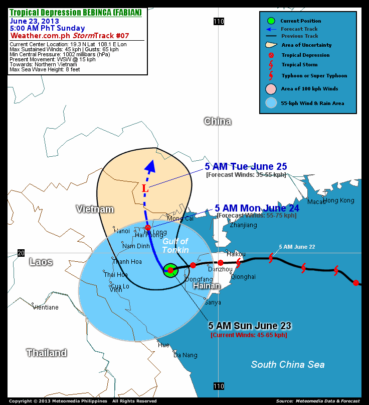
As of 5:00 am today, the center of TD Bebinca (Fabian) was located over the Gulf of Tonkin...about 67 km west-northwest of Dongfang, Hainan Island or 221 km south-southeast of Ha Long, Vietnam...currently moving west-southwest with a forward speed of 15 km/hr in the general direction of the Northern Vietnam.
Maximum Sustained Winds (1-min. avg) remains at 45 km/hr near the center with higher gusts. Bebinca (Fabian) is an average-sized tropical cyclone with a diameter of 445 kilometers across. The 24-hour rainfall accumulation near the center of Bebinca (Fabian) is estimated to be extreme (600 mm).
2-DAY FORECAST OUTLOOK*
TD Bebinca (Fabian) is expected to move north-northwest slowly for the next 12 hours...with a turn towards the north throughout the forecast period. On the forecast track, the core of Bebinca (Fabian) will make its final landfall over Northern Vietnam, very near Ha Long on Monday morning. The system will be just along the China-Vietnam border on Tuesday morning.
Bebinca (Fabian) is forecast to intensify slightly within the next 12 to 24 hours, while over the Gulf of Tonkin...and will gradually dissipate as it interacts with the land mass of Northern Vietnam on Monday morning. By Tuesday morning, it will be just an area of low pressure.
The following is the summary of the 2-day forecast outlook on this system:
MONDAY MORNING: Re-strengthens slightly as it makes its final landfall over Northern Vietnam...about 21 km east of Ha Long, Vietnam [5AM JUNE 24: 21.0N 107.2E @ 55kph].
TUESDAY MORNING: Dissipating along the China-Vietnam border...just an area of low pressure...about 167 km North of Ha Long, Vietnam [5AM JUNE 25: 22.5N 107.1E @ 35kph].
*Please be reminded that the Forecast Outlook changes every 6 hours, and the Day 3 Forecast Track have an average error of 250 km...while the wind speed forecast error, averages 35 kph per day. Therefore, a turn to the left or right of its future track and changes in its wind speed must be anticipated from time to time.
EFFECTS & HAZARDS SUMMARY
Below is the summary of the storm's parts and its hazards affecting specific areas. You can also view this image link for you to understand the parts.
RAINBANDS - spreading across the Gulf of Tonkin and Northern Vietnam. Affected Areas: Hainan Island and the Vietnamese cities of Nam Dinh-Hanoi-Hai Phong-Ha Long-Thanh Hoa-Mong Cai. Tropical Depression Conditions with light, moderate to strong winds (30-62 kph) will be expected along these bands (click here to know more about Rainbands).
24HR TOTAL RAINFALL ACCUMULATION - from 5 up to 200 mm (slight to heavy rainfall) can be expected along areas affected by the outer & inner rainbands (see above)...with isolated amounts of 201 to 600 mm (heavy to extreme) along areas to the south, west and near the center of Bebinca (Fabian).
Important Note: Please keep in mind that the above forecast outlook, effects and hazards summary changes every 6 to 12 hrs!
CURRENT TECHNICAL INFORMATION
Time/Date: 5:00 AM PhT Sun June 23, 2013
Class/Name: TD Bebinca (Fabian)
Location of Center: 19.3º N Lat 108.1º E Lon
Distance 1: 67 km WNW of Dongfang, Hainan Is.
Distance 2: 221 km SSE of Ha Long, Vietnam
Distance 3: 230 km SE of Hai Phong, Vietnam
Distance 4: 233 km SE of Nam Dinh, Vietnam
Distance 5: 245 km S of Mong Cai, Vietnam
Distance 6: 247 km ESE of Thanh Hoa, Vietnam
Distance 7: 306 km SE of Hanoi, Vietnam
MaxWinds (1-min avg): 45 kph near the center
Peak Wind Gusts: 65 kph
Present Movement: WSW @ 15 kph
Towards: Northern Vietnam
24hr Rainfall Accum (near center): Extreme [600 mm]
Minimum Central Pressure: 1002 millibars (hPa)
Size (in Diameter): 445 km [Average]
Max Sea Wave Height (near center): 8 feet
Possible Storm Surge Height: 0 ft (0 m)
T2K/WP StormTracks (for Public): GIF | Google Map (Flash)

CURRENT NOAA/MTSAT-2 INFRARED (IR) SATELLITE IMAGE:

CURRENT TRACKING MAP:
 _____________________________________________________________________________
>> To know the meteorological terminologies and acronyms used on this update visit the ff:
http://typhoon2000.ph/tcterm.htm
http://www.nhc.noaa.gov/aboutgloss.shtml
http://www.nhc.noaa.gov/acronyms.shtml
__________________________________________________________________________________________
For the complete details on TD BEBINCA (FABIAN)...go visit our website @:
> http://www.typhoon2000.com
> http://www.maybagyo.com
<<<Typhoon2000.com Mobile >>>
Get the latest SMS Storm Alerts!
For more details: Text T2K TYPHOON to
2800 (Globe/TM) | Offline (Smart/TNT) | 2288 (Sun)
*Only P2.50 (Smart/Globe) / P2.00 (Sun) per msg received.
Click here on how to use this service (in PDF file)
Powered by: Synermaxx Corporation
Copyright © 2013 Typhoon2000.com All Rights Reserved
| Reply via web post | Reply to sender | Reply to group | Start a New Topic | Messages in this topic (1) |

No comments:
Post a Comment