
Typhoon2000 (T2K) NEWS (Monday August 20, 2012):
Currently issuing 6-hrly web, SMS, email, & iTyphoon app updates (except 12 Midnight) on TEMBIN (IGME).
TEMBIN MAX WIND SPEED PER AGENCY:
+ USA (JTWC/1-min avg): 140 km/hr
+ Japan (JMA/10-min avg): 120 km/hr
+ Philippines (PAGASA/10-min avg): 105 km/hr
+ Beijing (NMC/2-min avg): 145 km/hr
+ Taiwan (CWB/10-min avg): 120 km/hr
+ Korea (KMA/10-min avg): 110 km/hr
+ Hong Kong (HKO/10-min avg): 120 km/hr
:: Click here to see Multi-Agency Forecast Tracks
TYPHOON2000 (T2K) TROPICAL CYCLONE UPDATES
TYPHOON TEMBIN (IGME) UPDATE NUMBER 004
12:00 NN PhT (04:00 GMT) Mon 20 August 2012
Sources: T2K Analysis/Dynamic Models/SatFixes
View: T2K TC Update Archives (2004-2012)
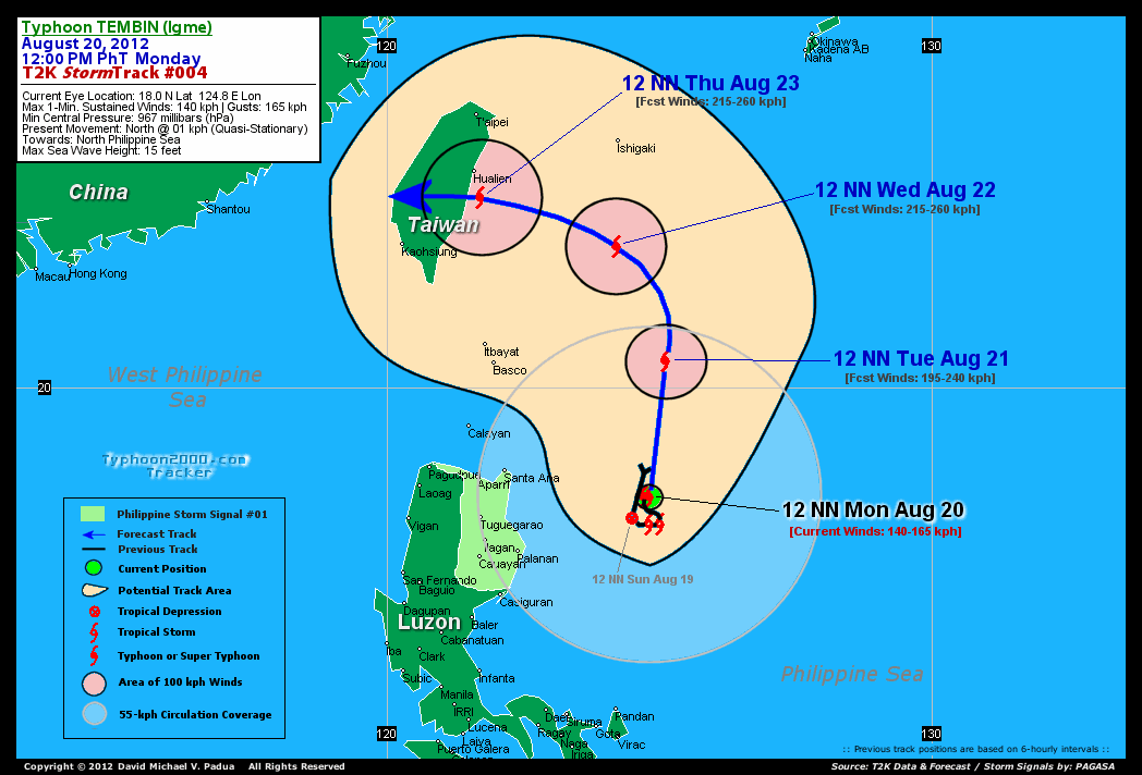
Typhoon TEMBIN (IGME) barely moving over the Philippine Sea, east of Cagayan...maintained its rapid intensification processs as it eyes Taiwan.
Meanwhile, since the Southwest Monsoon (Habagat) remains weak, the pull of Typhoon TEMBIN on this seasonal wind system is not much. However, isolated to scattered rains and thunderstorms will continue is some parts of Luzon including Metro Manila and Baguio City.
Meanwhile, another cyclone has formed over the Western Pacific Ocean, hundreds of kilometers to the NNW of Guam. Check out the latest details on Tropical Depression 16W (Unnamed) at the TROPICAL CYCLONE WATCH section of this page.
Residents and visitors along Northern Luzon and Taiwan should closely monitor the progress of TEMBIN (IGME).
Do not use this for life or death decision. This advisory is intended for additional information purposes only. Kindly refer to your country's official weather agency for local warnings, advisories & bulletins.
CURRENT STORM INFORMATION
Time/Date: 12:00 NN PhT Mon August 20, 2012
Location of Eye: 18.0º N Lat 124.8º E Lon
Distance 1: 278 km (ENE) away from Palanan, Isabela
Distance 2: 280 km (ESE) away from Santa Ana, Cagayan
Distance 3: 331 km (ENE) away from Tuguegarao City
Distance 4: 350 km (NE) away from Casiguran, Aurora
Distance 5: 330 km (ESE) away from Aparri, Cagayan
Distance 6: 376 km (SE) away from Calayan Island
Distance 7: 438 km (NNE) away from Pandan, Catanduanes
Distance 8: 404 km (SE) closer to Basco, Batanes
Distance 9: 518 km (NNE) away from Metro Naga/CWC
Distance 10: 554 km (NE) away from Metro Manila
MaxWinds (1-min avg): 140 kph (75 kts) near the center
Peak Wind Gusts: 165 kph (90 kts)
Present Movement: North @ 01 kph (0.5 kt)
Towards: North Philippine Sea
NOAA 24hr Rainfall Accum (near center): 350 mm (High)
Minimum Central Pressure: 967 millibars (hPa)
Saffir-Simpson Typhoon Scale: Category 1
Size (in Diameter): 665 km (360 nm) [Average]
Wind Area Distribution (in Knots): Current Wind Profile
Max Sea Wave Height (near center): 15 ft
Possible Storm Surge Height: 4-5 ft [1.3-1.7 m]
T2K StormTracks (for Public): Google Map (Flash) | GIF (for Philippines only)
3-DAY FORECAST OUTLOOK & ANALYSIS*
TEMBIN (IGME) is expected to move very slowly northward during the next 12 to 36 hours...and will turn sharply NW to Westward during the next 48 to 72 hours. On the forecast track, the core of TEMBIN will not directly affect any part of the Philippines as it will remain over the open sea. This typhoon will be approaching the East Coast of Taiwan late Wednesday...and will make landfall just south of Hualien City on Thursday morning or noontime.
Maximum Sustained Winds (1-min. avg) have rapidly increased to near 140 km/hr (75 knots) with higher gusts. Continued increase in strength will be expected during the next few days...and TEMBIN will become a Category 3 Typhoon on Tuesday.
Typhoon Force Winds (118 km/hr or more) extend outward up to 20 kilometers (10 nautical miles) from the center...and Tropical Storm Force Winds (62-117 km/hr) extend outward up to 95 kilometers (50 nautical miles) from the center. TEMBIN is an average-sized tropical cyclone with a diameter of 665 kilometers (360 nautical miles) across.
The following is the summary of the 3-day forecast outlook on this system:
 TUESDAY NOON: Strengthens into a Category 3 Typhoon as it maintains its northerly track while off the North Philippine Sea...323 km East of Basco, Batanes [12PM AUG 21: 20.5N 125.1E @ 195kph].
WEDNESDAY NOON: Reaches to Category 4 as it starts turning NW to WNW-ward towards Taiwan...about 308 km SE of Hualien City, Taiwan [12PM AUG 22: 22.6N 124.2E @ 215kph].
THURSDAY NOON: Prepares to make landfall along Eastern Taiwan, just south of Hualien City...turns Westward...about 57 km SSE of Hualien City, Taiwan [12PM AUG 23: 23.5N 121.7E @ 215kph].
*Please be reminded that the Forecast Outlook changes every 6 hours, and the Day 3 Forecast Track have an average error of 250 km...while the wind speed forecast error, averages 35 kph per day. Therefore, a turn to the left or right of its future track and changes in its wind speed must be anticipated from time to time.
EFFECTS & HAZARDS SUMMARY
Below is the summary of the storm's parts and its hazards affecting specific areas. You can also view this image link for you to understand the parts.
RAGGED EYE - over water (North Philippine Sea). Possible calm and lull conditions (with <20 kph winds) will be expected inside the eye (click here to know more about the EYE). EYEWALL - over water (North Philippine Sea)...not yet affecting any land areas. Typhoon Conditions with Typhoon Force Winds (>118 kph) will be expected within this wall (click here to know more about the Eyewall). INNER RAINBANDS - over water (North Philippine Sea)...not affecting any land areas. Tropical Storm Conditions with Tropical Storm Force Winds (62-118 kph) will be expected along these bands. OUTER RAINBANDS - particularly the southwestern bands are affecting & spreading across the coastal areas of Cagayan and Isabela. Cloudy/Rainy Conditions with moderate to strong winds (<62 kph) will be expected along these bands (click here to know more about Rainbands). 24HR TOTAL RAINFALL ACCUMULATION - from 5 up to 200 mm (low to high rainfall) can be expected along areas affected by the outer & inner rainbands (see above)...with isolated amounts of 201 to 350 mm (high to very high) along areas near the center of Tembin (Igme) (click to open NOAA's eTRaP graphic). COASTAL STORM SURGE FLOODING - possible 4-5 ft (1.2-1.7 m) above normal tide levels...accompanied by large and dangerous battering waves can be expected along the coastal, inland lakes and beach front areas of Cagayan, Isabela and the Batanes-Calayan-Babuyan Island Group. Minimal damage is likely on this type of storm surge. Danger from Rip Currents or Rip Tides can be expected along the rest of the beach-front areas of Eastern and Northern Luzon and Taiwan (click here to know more about Storm Surge).
TROPICAL CYCLONE WATCH
Meanwhile, Tropical Depression 16W (Unnamed) rapidly consolidating over Western Pacific Ocean, with no threat to land. Its center was located about 592 km NW of Guam, CNMI (17.6N 141.4E)...with maximum sustained winds of 55 kph and was moving NNW @ 13 kph. To view the latest information on this storm kindly click and visit this link.
CURRENT SW MONSOON INTENSITY: WEAK >> Partly sunny to mostly cloudy skies with some isolated to scattered showers, rains or thunderstorms will be expected along the following affected areas: REST OF LUZON paerticularly the WESTERN SECTIONS including METRO MANILA. Calm & light to moderate SW'ly winds (not in excess of 35 kph) will blow across the abovementioned areas.
Important Note: Please keep in mind that the above forecast outlook, effects-hazards, current monsoon intensity, & tropical cyclone watch changes every 6 to 12 hrs!![]()
PAGASA Philippine Storm Warnings Signals
Kindly visit: The official PAGASA Website to view the Signals hoisted
External Links for TY TEMBIN (IGME)
PAGASA: Hourly Updates
View NOAA-CIRA's: Latest Full Wind Analysis
JTWC Latest Tracking Chart: wp1512.gif
Multi-Agency Forecast TrackMap: Near Real-Time
TSR Wind Probabilities: Current to 5 Days Ahead
JAXA TRMM Page: Latest Rainrate (in mm/hr)
NASA TRMM Page: Tembin's Rainrate Archives (in mm/hr)
Zoomed Satellite Pic: NOAA's Near Real-Time
Wunderground Animation: 6-12 hr. GIF Loop
CURRENT NOAA/MTSAT-2 SATELLITE IMAGE:

CURRENT TYPHOON2000.COM TRACKING MAP:
_____________________________________________________________________________
>> To know the meteorological terminologies and acronyms used on this update visit the ff:
http://typhoon2000.ph/tcterm.htm
http://www.nhc.noaa.gov/aboutgloss.shtml
http://www.nhc.noaa.gov/acronyms.shtml
__________________________________________________________________________________________
For the complete details on TY TEMBIN (IGME)...go visit our website @:
> http://www.typhoon2000.com
> http://www.maybagyo.com
<<<Typhoon2000.com Mobile >>>
Get the latest SMS Storm Alerts!
For more details: Text T2K TYPHOON to
2800 (Globe/TM) | 216 (Smart/TNT) | 2288 (Sun)
*Only P2.50 (Smart/Globe) / P2.00 (Sun) per msg received.
Click here on how to use this service (in PDF file)
Powered by: Synermaxx Corporation
Copyright © 2012 Typhoon2000.com All Rights Reserved
| Reply via web post | Reply to sender | Reply to group | Start a New Topic | Messages in this topic (1) |

No comments:
Post a Comment