
Typhoon2000 (T2K) NEWS (Saturday July 28 2012):
Currently issuing the 6-hrly web, email, SMS & iTyphoon app updates (except 12 Midnight) on SAOLA (GENER).
SAOLA MAX WIND SPEED PER AGENCY:
+ USA (JTWC/1-min avg): 160 km/hr
+ Japan (JMA/10-min avg): 120 km/hr
+ Philippines (PAGASA/10-min avg): 120 km/hr
+ Beijing (NMC/2-min avg): 145 km/hr
+ Taiwan (CWB/10-min avg): 125 km/hr
+ Korea (KMA/10-min avg): 140 km/hr
+ Hong Kong (HKO/10-min avg): 120 km/hr
:: Click here to see Multi-Agency Forecast Tracks
TYPHOON2000 (T2K) TROPICAL CYCLONE UPDATES
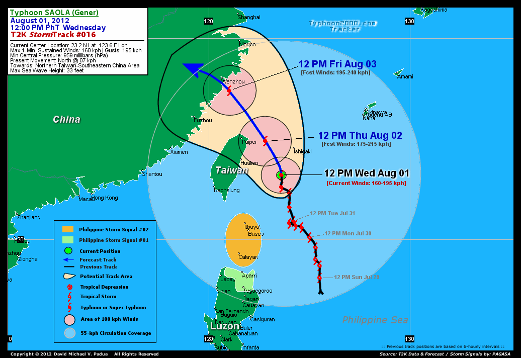
TYPHOON SAOLA (GENER) UPDATE NUMBER 016
12:00 PM PhT (04:00 GMT) Wed 01 August 2012
Sources: T2K Analysis/Dynamical Models/Sat+RadarFixes
View: T2K TC Update Archives (2004-2012)
Typhoon SAOLA (GENER) intensifying rapidly as it passes in between Taiwan & Ishigaki Island Group. Eyewall approaching the smaller islands west of Ishigaki Jima. Southwestern outer rainbands still affecting Extreme Northern Luzon.
This storm will continue to enhance the Southwest Monsoon (aka. Habagat) across Metro Manila, Southern Tagalog Provinces, Rest of Luzon, Bicol Region, Mindoro, Visayas & Palawan today. Breezy to windy conditions & mostly cloudy conditions w/ occasionally passing rains, thunderstorms & squalls will be expected along the abovementioned areas, especially along the western coast. The seas along the coastal areas facing the West, East and North Philippine Seas will be rough and dangerous.
Residents and visitors along Extreme Northern Luzon, Taiwan and Southeastern China should closely monitor the progress of Saola (Gener).
Do not use this for life or death decision. This advisory is intended for additional information purposes only. Kindly refer to your country's official weather agency for local warnings, advisories & bulletins.
CURRENT STORM INFORMATION
Time/Date: 12:00 PM PhT Wed August 01 2012
Location of Eye: 23.2� N Lat 123.6� E Lon
Distance 1: 157 km SSW of Ishigaki Jima
Distance 2: 222 km ESE of Hualien, Taiwan
Distance 3: 285 km SE of Taipei, Taiwan
Distance 4: 325 km NNE of Itbayat, Batanes
Distance 5: 343 km NNE of Basco, Batanes
Distance 6: 541 km SE of Fuzhou, China
Distance 7: 546 km SW of Okinawa, Japan
Distance 8: 613 km SSE of Wenzhou, China
MaxWinds (1-min avg): 160 kph (85 kts) near the center
Peak Wind Gusts: 195 kph (105 kts)
Present Movement: North @ 07 kph (04 kts)
Towards: Northern Taiwan-SE China
CPA [ETA] to Ishigaki Islands: Thursday [12-6AM PhT]
NOAA 24hr Rainfall Accum (near center): 400 mm (VHigh)
Minimum Central Pressure: 959 millibars (hPa)
Saffir-Simpson Typhoon Scale: Category 2
Size (in Diameter): 1,480 km (800 nm) [Very Large]
Wind Area Distribution (in Knots): Current Wind Profile
Max Sea Wave Height (near center): 33 ft
Possible Storm Surge Height: 6-8 ft [1.8-2.6 m]
T2K StormTracks (for Public): Google Map (Flash) | GIF
3-DAY FORECAST OUTLOOK & ANALYSIS*
SAOLA (GENER) is expected to move NNW for the next 24 hours with a slow increase in its forward speed...will slightly bend NW to WNW-ward within 48 to 72 hours. On the forecast track, the core of SAOLA will pass in between Eastern Taiwan and Ishigaki Island Group tonight until Thursday morning and will move out of the Philippine Area of Responsibility (PAR) Thursday afternoon. On Friday noon, SAOLA will be just along the coast of Zhejiang Province...making landfall very near Wenzhou City Friday afternoon, and will then start to move over land across Zhejiang Province Friday evening through Saturday noon.
Maximum Sustained Winds (1-min. avg) have rapidly increased to near 160 km/hr (85 knots) with higher gusts. More strengthening is forecast during the next 1 to 2 days, and SAOLA is expected to become a Category 3 Typhoon by Thursday night.
Typhoon Force Winds (118 km/hr or more) extend outward up to 75 kilometers (40 nautical miles) from the center...and Tropical Storm Force Winds (62-117 km/hr) extend outward up to 260 kilometers (140 nautical miles). SAOLA is a large-sized tropical cyclone with a diameter of 1,480 kilometers (800 nautical miles).
The following is the summary of the 3-day forecast outlook on this system:
 THURSDAY NOON: Nears Category 2 strength after moving in between Eastern Taiwan and Ishigaki Island Group...about 121 km East of Taipei, Taiwan [12PM AUG 02: 24.9N 122.8E @ 175kph].
FRIDAY NOON: Becomes a Category 3 Typhoon as it turns NW...moving onshore off Zhejiang Province...about 77 km SSE of Wenzhou City, China [12PM AUG 03: 27.4N 121.0E @ 195kph].
SATURDAY NOON: Downgraded to a Tropical Storm (TS) as it moves over land across Zhejiang Province...about 250 km WNW of Wenzhou City, China [12PM AUG 04: 28.5N 118.2E @ 85kph].
*Please be reminded that the Forecast Outlook changes every 6 hours, and the Day 3 Forecast Track have an average error of 250 km...while the wind speed forecast error, averages 35 kph per day. Therefore, a turn to the left or right of its future track and changes in its wind speed must be anticipated from time to time.
EFFECTS & HAZARDS SUMMARY
Below is the summary of the storm's parts and its hazards affecting specific areas:
RAGGED EYE - over water (North Philippine Sea). Possible calm and lull conditions (with <20 kph winds) will be expected inside the eye (click here to know more about the EYE). EYEWALL - over water (North Philippine Sea)...not yet affecting any land areas...but will reach the tiny islands west of Ishigaki Jima later tonight. Typhoon Conditions with Typhoon Force Winds (>118 kph) will be expected within this wall (click here to know more about the Eyewall). INNER RAINBANDS - affecting and spreading across Ishigaki Island Group and the Eastern Coastline of Taiwan. Tropical Storm Conditions with Tropical Storm Force Winds (62-100 kph) will be expected along these bands. OUTER RAINBANDS - affecting & spreading across Extreme Northern Luzon, Southeastern China and the Rest of Taiwan including Okinawa Group of Islands. Cloudy/Rainy Conditions with moderate to strong winds (<62 kph) will be expected along these bands (click here to know more about Rainbands). 24HR TOTAL RAINFALL ACCUMULATION - from 5 up to 200 mm (low to high rainfall) can be expected along areas affected by the outer & inner rainbands (see above)...with isolated amounts of 201 to 400 mm (very high) along areas near the center of Saola (Gener). (click to open NOAA's eTRaP graphic). COASTAL STORM SURGE FLOODING - possible 6-8 ft (1.8-2.6 m) above normal tide levels...accompanied by large and dangerous battering waves can be expected along the coastal, inland lakes and beach front areas of Extreme Northern Luzon, Eastern Taiwan, & Ishigaki Island Group. Moderate damage is likely on this type of storm surge. Danger from Rip Currents or Rip Tides can be expected along the rest of the beach-front areas of Eastern Philippines and Southeastern China. (click here to know more about Storm Surge).
TROPICAL CYCLONE WATCH
Tropical Storm (TS) DAMREY (11W) now passing along the southern coast of Kyushu, Japan with Tropical Storm Conditions expected along the path of this fast-moving system. Its center was located about 163 km SSE of Kagoshima, Japan or 295 km NE of Amami Island, Japan (30.3N 131.4E)...with maximum sustained winds of 100 kph and was moving WNW @ 37 kph towards East China Sea. To view the latest information on this storm kindly click this link.
CURRENT SW MONSOON INTENSITY: MODERATE >> Mostly cloudy skies with occasional showers, rains or thunderstorms w/ squalls will be expected along the following affected areas: METRO MANILA, SOUTHERN TAGALOG PROVINCES, REST OF LUZON, MINDORO, BICOL REGION, VISAYAS, & WESTERN MINDANAO. Moderate to strong SW'ly winds (not in excess of 40 kph) will blow across the abovementioned areas.
Important Note: Please keep in mind that the above forecast outlook, effects-hazards, current monsoon intensity, & tropical cyclone watch changes every 6 to 12 hrs!![]()
PAGASA Philippine Storm Warnings Signals
Kindly visit: The official PAGASA Website to view the Signals hoisted
External Links for TY SAOLA (GENER)
PAGASA: Hourly Updates
View NOAA-CIRA's: Latest Full Wind Analysis
JTWC Latest Tracking Chart: wp1012.gif
Multi-Agency Forecast TrackMap: Near Real-Time
TSR Wind Probabilities: Current to 4 Days Ahead
JAXA TRMM Page: Latest Rainrate (in mm/hr)
NASA TRMM Page: Saola's Rainrate Archives (in mm/hr)
Zoomed Satellite Pic: NOAA's Near Real-Time
Wunderground Animation: 6-12 hr. GIF Loop
CURRENT NOAA/MTSAT-2 SATELLITE IMAGE:

CURRENT TYPHOON2000.COM TRACKING MAP:
_____________________________________________________________________________
>> To know the meteorological terminologies and acronyms used on this update visit the ff:
http://typhoon2000.ph/tcterm.htm
http://www.nhc.noaa.gov/aboutgloss.shtml
http://www.nhc.noaa.gov/acronyms.shtml
__________________________________________________________________________________________
For the complete details on TY SAOLA (GENER)...go visit our website @:
> http://www.typhoon2000.com
> http://www.maybagyo.com
<<<Typhoon2000.com Mobile >>>
Get the latest SMS Storm Alerts!
For more details: Text T2K TYPHOON to
2800 (Globe/TM) | 216 (Smart/TNT) | 2288 (Sun)
*Only P2.50 (Smart/Globe) / P2.00 (Sun) per msg received.
Click here on how to use this service (in PDF file)
Powered by: Synermaxx Corporation
Copyright © 2012 Typhoon2000.com All Rights Reserved

No comments:
Post a Comment