
Typhoon2000 (T2K) NEWS (Monday August 13, 2012):
Currently issuing 6-hrly web, SMS, email, & iTyphoon app updates (except 12 Midnight) on KAI-TAK (HELEN).
KAI-TAK MAX WIND SPEED PER AGENCY:
+ USA (JTWC/1-min avg): 65 km/hr
+ Japan (JMA/10-min avg): 65 km/hr
+ Philippines (PAGASA/10-min avg): 65 km/hr
+ Beijing (NMC/2-min avg): 65 km/hr
+ Taiwan (CWB/10-min avg): 65 km/hr
+ Korea (KMA/10-min avg): 65 km/hr
+ Hong Kong (HKO/10-min avg): 55 km/hr
:: Click here to see Multi-Agency Forecast Tracks
TYPHOON2000 (T2K) TROPICAL CYCLONE UPDATES
TROPICAL STORM KAI-TAK (HELEN) UPDATE NUMBER 003
6:00 PM PhT (10:00 GMT) Mon 13 August 2012
Sources: T2K Analysis/Dynamic Models/SatFixes
View: T2K TC Update Archives (2004-2012)
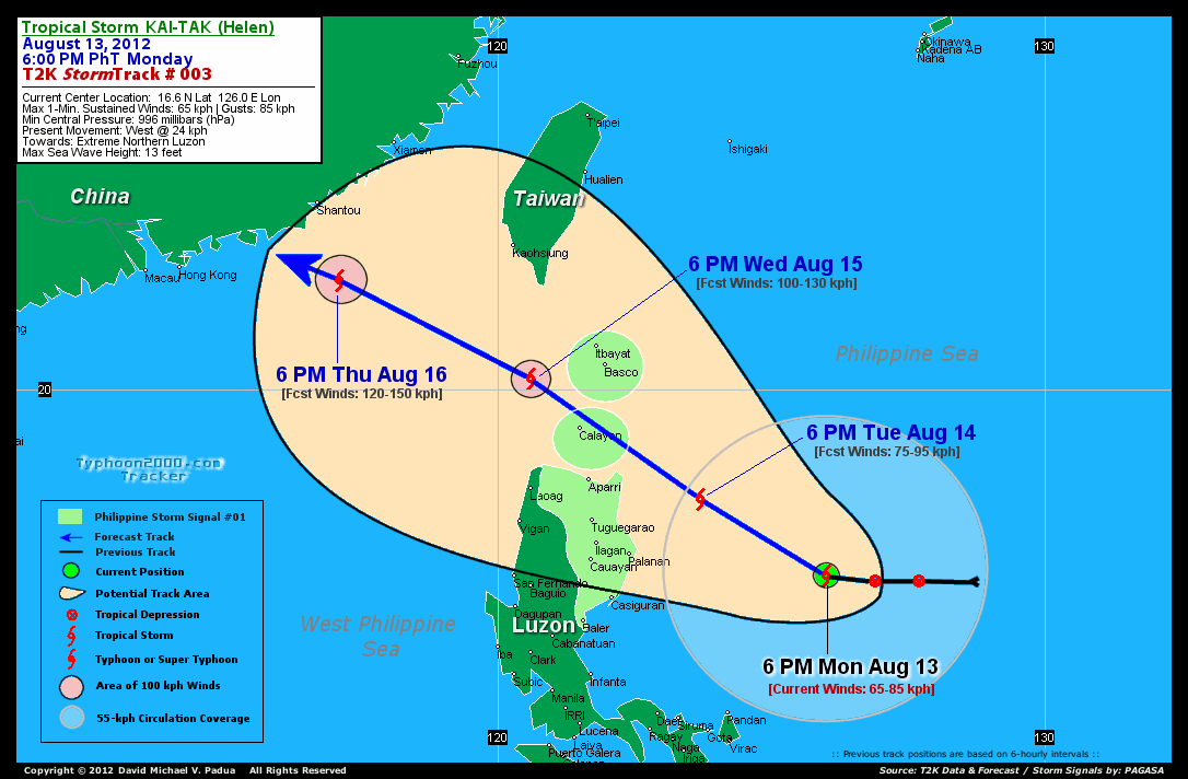
KAI-TAK (HELEN) becomes a Tropical Storm as it continues to move closer to Extreme Northern Luzon.
Meanwhile, KAI-TAK will enhance the Southwest Monsoon (aka. Habagat) across the Western Sections of Luzon incl. Metro Manila beginning tonight until Thursday. Mostly cloudy conditions w/ scattered to passing occasional showers, rains & thunderstorms will be expected along the abovementioned areas. The seas along the coastal areas facing the West, East and North Philippine Seas will be slight to moderate.
Residents and visitors along Extreme Northern and Northern Luzon, and Taiwan should closely monitor the progress of KAI-TAK (HELEN).
Do not use this for life or death decision. This advisory is intended for additional information purposes only. Kindly refer to your country's official weather agency for local warnings, advisories & bulletins.
CURRENT STORM INFORMATION
Time/Date: 6:00 PM PhT Mon August 13, 2012
Location of Center: 16.6º N Lat 126.0º E Lon
Distance 1: 377 km (ESE) closer to Palanan Bay, Isabela
Distance 2: 418 km (ENE) closer to Casiguran, Aurora
Distance 3: 452 km (ESE) closer to Ilagan City
Distance 4: 459 km (ESE) closer to Cauayan City
Distance 5: 464 km (SE) closer to Sta. Ana, Cagayan
Distance 6: 498 km (ESE) closer to Aparri, Cagayan
Distance 7: 563 km (SE) closer to Calayan Is., Cagayan
Distance 8: 338 km (NNE) away from Pandan, Catanduanes
Distance 9: 449 km (NE) away from Metro Naga/CWC
MaxWinds (1-min avg): 65 kph (35 kts) near the center
Peak Wind Gusts: 85 kph (45 kts)
Present Movement: West @ 24 kph (13 kts)
Towards: Extreme Northern Luzon
CPA [ETA] to Northern Cagayan: Tue-Wed [8PM-8AM PHT]
NOAA 24hr Rainfall Accum (near center): 700 mm (VHigh)
Minimum Central Pressure: 996 millibars (hPa)
Saffir-Simpson Typhoon Scale: TS
Size (in Diameter): 610 km (330 nm) [Average]
Wind Area Distribution (in Knots): Current Wind Profile
Max Sea Wave Height (near center): 13 ft
Possible Storm Surge Height: 1-3 ft [0.3-0.9 m]
T2K StormTracks (for Public): Google Map (Flash) | GIF
3-DAY FORECAST OUTLOOK & ANALYSIS*
KAI-TAK (HELEN) is expected to move NW-ward during the next 24 hours...before turning WNW-ward through 72 hours w/ little change in its forward speed. On the forecast track, the core of KAI-TAK will be traversing the Calayan-Babuyan-Batanes Group of Islands on Wednesday morning, passing very near Calayan Island...and exit the Philippine Area of Responsibility (PAR) by early Thursday.
Maximum Sustained Winds (1-min. avg) have increased to near 65 km/hr (35 knots) with higher gusts. Continued strengthening is forecast during the next 3 days...and KAI-TAK could become a Typhoon on Thursday.
The following is the summary of the 3-day forecast outlook on this system:
 TUESDAY EVENING: Gain strength as it approaches the east coast of Northern Cagayan...about 178 km ESE of Santa Ana, Cagayan [6PM AUG 14: 18.0N 123.7E @ 75kph].
WEDNESDAY EVENING: Still gaining strength while traversing the Calayan-Babuyan-Batanes Group of Islands...moving into the West Philippine Sea...about 140 km WSW of Basco, Batanes [6PM AUG 15: 20.2N 120.6E @ 100kph].
THURSDAY EVENING: Becomes a Typhoon as it approaches Southern China...about 160 km SSE of Shantou City, China [6PM AUG 16: 22.0N 117.1E @ 120kph].
*Please be reminded that the Forecast Outlook changes every 6 hours, and the Day 3 Forecast Track have an average error of 250 km...while the wind speed forecast error, averages 35 kph per day. Therefore, a turn to the left or right of its future track and changes in its wind speed must be anticipated from time to time.
EFFECTS & HAZARDS SUMMARY
Below is the summary of the storm's parts and its hazards affecting specific areas:
INNER RAINBANDS - over water (Philippine Sea)...not affecting any land areas...but will reach the eastern coast of Cagayan Tuesday evening. Tropical Storm Conditions with Tropical Storm Force Winds (62-100 kph) will be expected along these bands. DEVELOPING RAINBANDS - affecting & spreading across the coastal areas Eastern & NE Luzon and Bicol Region. Cloudy/Rainy Conditions with moderate to strong winds (<62 kph) will be expected along these bands (click here to know more about Rainbands). 24HR TOTAL RAINFALL ACCUMULATION - from 5 up to 200 mm (low to high rainfall) can be expected along areas affected by the outer & inner rainbands (see above)...with isolated amounts of 201 to 700 mm (high to very high) along areas near the center of Kai-tak (Helen) (click to open NOAA's eTRaP graphic). COASTAL STORM SURGE FLOODING - possible 1-3 ft (0.3-0.9 m) above normal tide levels...accompanied by large and dangerous battering waves can be expected along the coastal, inland lakes and beach front areas of Northeastern Luzon. Very minimal damage is likely on this type of storm surge. Danger from Rip Currents or Rip Tides can be expected along the rest of the beach-front areas of Luzon. (click here to know more about Storm Surge).
CURRENT SW MONSOON INTENSITY: MODERATE >> Partly sunny to mostly cloudy skies with some scattered showers, rains or thunderstorms will be expected along the following affected areas: WESTERN LUZON & MINDORO incl. CALAMIAN GROUP OF ISLANDS & METRO MANILA. Light to moderate SW'ly winds (not in excess of 35 kph) will blow across the abovementioned areas.
Important Note: Please keep in mind that the above forecast outlook, effects-hazards, current monsoon intensity, & tropical cyclone watch changes every 6 to 12 hrs!![]()
PAGASA Philippine Storm Warnings Signals
Kindly visit: The official PAGASA Website to view the Signals hoisted
External Links for TS KAI-TAK (HELEN)
PAGASA: Hourly Updates
View NOAA-CIRA's: Latest Full Wind Analysis
JTWC Latest Tracking Chart: wp1412.gif
Multi-Agency Forecast TrackMap: Near Real-Time
TSR Wind Probabilities: Current to 5 Days Ahead
JAXA TRMM Page: Latest Rainrate (in mm/hr)
NASA TRMM Page: Kai-tak's Rainrate Archives (in mm/hr)
Zoomed Satellite Pic: NOAA's Near Real-Time
Wunderground Animation: 6-12 hr. GIF Loop
CURRENT NOAA/MTSAT-2 SATELLITE IMAGE:

CURRENT TYPHOON2000.COM TRACKING MAP:
_____________________________________________________________________________
>> To know the meteorological terminologies and acronyms used on this update visit the ff:
http://typhoon2000.ph/tcterm.htm
http://www.nhc.noaa.gov/aboutgloss.shtml
http://www.nhc.noaa.gov/acronyms.shtml
__________________________________________________________________________________________
For the complete details on TS KAI-TAK (HELEN)...go visit our website @:
> http://www.typhoon2000.com
> http://www.maybagyo.com
<<<Typhoon2000.com Mobile >>>
Get the latest SMS Storm Alerts!
For more details: Text T2K TYPHOON to
2800 (Globe/TM) | 216 (Smart/TNT) | 2288 (Sun)
*Only P2.50 (Smart/Globe) / P2.00 (Sun) per msg received.
Click here on how to use this service (in PDF file)
Powered by: Synermaxx Corporation
Copyright © 2012 Typhoon2000.com All Rights Reserved
| Reply via web post | Reply to sender | Reply to group | Start a New Topic | Messages in this topic (1) |

No comments:
Post a Comment