
Typhoon2000 (T2K) NEWS (Sunday August 19, 2012):
Now issuing 6-hrly web, SMS, email, & iTyphoon app updates (except 12 Midnight) on TEMBIN (IGME).
TEMBIN MAX WIND SPEED PER AGENCY:
+ USA (JTWC/1-min avg): 55 km/hr
+ Japan (JMA/10-min avg): 65 km/hr
+ Philippines (PAGASA/10-min avg): 55 km/hr
+ Beijing (NMC/2-min avg): 65 km/hr
+ Taiwan (CWB/10-min avg): 65 km/hr
+ Korea (KMA/10-min avg): 65 km/hr
+ Hong Kong (HKO/10-min avg): 65 km/hr
:: Click here to see Multi-Agency Forecast Tracks
TYPHOON2000 (T2K) TROPICAL CYCLONE UPDATES
TROPICAL DEPRESSION TEMBIN (IGME) UPDATE NUMBER 001
12:00 NN PhT (04:00 GMT) Sun 19 August 2012
Sources: T2K Analysis/Dynamic Models/SatFixes
View: T2K TC Update Archives (2004-2012)
The small but strong disturbance (LPA) over the North Philippine Sea, near the coast of Cagayan has strengthened into Tropical Depression TEMBIN (IGME). TEMBIN is a Japanese word for a weighing scale device. Developing rainbands spreading across Cagayan and Isabela.
Meanwhile, since the Southwest Monsoon (Habagat) remains weak, the pull of TD TEMBIN on this seasonal wind system is not much. However, isolated to scattered rains and thunderstorms can still be expected across much of Luzon including Metro Manila.
Residents and visitors along Northern Luzon and Taiwan should closely monitor the progress of TEMBIN (IGME).
Do not use this for life or death decision. This advisory is intended for additional information purposes only. Kindly refer to your country's official weather agency for local warnings, advisories & bulletins.
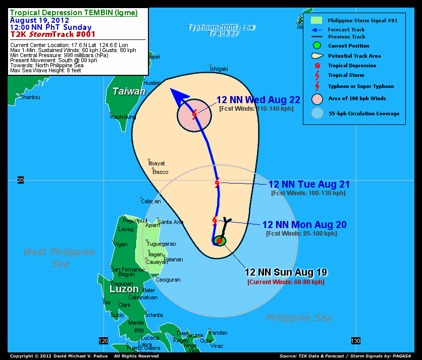
CURRENT STORM INFORMATION
Time/Date: 12:00 NN PhT Sun August 19, 2012
Location of Center: 17.6º N Lat 124.6º E Lon
Distance 1: 243 km (ENE) closer to Palanan, Isabela
Distance 2: 273 km (ESE) away from Santa Ana, Cagayan
Distance 3: 307 km (E) away from Tuguegarao City
Distance 4: 308 km (NE) closer to Casiguran, Aurora
Distance 5: 329 km (ESE) away from Aparri, Cagayan
Distance 6: 378 km (SE) away from Calayan Island
Distance 7: 391 km (N) closer to Pandan, Catanduanes
Distance 8: 423 km (SE) away from Basco, Batanes
Distance 9: 469 km (NNE) closer to Metro Naga/CWC
Distance 10: 516 km (NE) away from Metro Manila
MaxWinds (1-min avg): 60 kph (33 kts) near the center
Peak Wind Gusts: 80 kph (43 kts)
Present Movement: South @ 09 kph (05 kts)
Towards: North Philippine Sea
Minimum Central Pressure: 998 millibars (hPa)
Saffir-Simpson Typhoon Scale: Tropical Depression
Size (in Diameter): 665 km (360 nm) [Average]
Wind Area Distribution (in Knots): Current Wind Profile
Max Sea Wave Height (near center): 8 ft
Possible Storm Surge Height: 0 ft [0 m]
T2K StormTracks (for Public): Google Map (Flash) | GIF (for Philippines only)
3-DAY FORECAST OUTLOOK & ANALYSIS*
TEMBIN (IGME) is expected to continue drifting southward during the next 12 hours...and will reverse track northward through the next 36 hours. By 48 to 72 hours, TEMBIN will start turning NW to WNW-ward. On the forecast track, the core of TEMBIN will not directly affect any part of the Philippines as it will remain over the open sea through Tuesday...with a path towards Eastern Taiwan.
Maximum Sustained Winds (1-min. avg) are near 60 km/hr (33 knots) with higher gusts. Continued increase in strength will be expected during the next few days...and KAI-TAK will become a Tropical Storm later today.
The following is the summary of the 3-day forecast outlook on this system:
 MONDAY NOON: Reaches Tropical Storm strength as it starts to turn Northward while near the coast of Cagayan...239 km ESE of Santa Ana [12NN AUG 20: 18.0N 124.4E @ 85kph].
TUESDAY NOON: Accelerating northward away from the coast of Cagayan...about 269 km ESE of Basco, Batanes [12NN AUG 21: 19.9N 124.5E @ 100kph].
WEDNESDAY NOON: Start turning NW across the North Philippine Sea, away from Extreme Northern Luzon towards Eastern Taiwan...about 257 km SE of Hualien City, Taiwan [12NN AUG 22: 22.6N 123.6E @ 110kph].
*Please be reminded that the Forecast Outlook changes every 6 hours, and the Day 3 Forecast Track have an average error of 250 km...while the wind speed forecast error, averages 35 kph per day. Therefore, a turn to the left or right of its future track and changes in its wind speed must be anticipated from time to time.
EFFECTS & HAZARDS SUMMARY
Below is the summary of the storm's parts and its hazards affecting specific areas. You can also view this image link for you to understand the parts.
DEVELOPING RAINBANDS - the southwestern bands are affecting & spreading across the provinces of Cagayan and Isabela. Cloudy/Rainy Conditions with moderate to strong winds (<62 kph) will be expected along these bands (click here to know more about Rainbands).
CURRENT SW MONSOON INTENSITY: WEAK >> Partly sunny to mostly cloudy skies with some isolated to scattered showers, rains or thunderstorms will be expected along the following affected areas: REST OF LUZON paerticularly the WESTERN SECTIONS including METRO MANILA. Calm & light to moderate SW'ly winds (not in excess of 35 kph) will blow across the abovementioned areas.
Important Note: Please keep in mind that the above forecast outlook, effects-hazards, current monsoon intensity, & tropical cyclone watch changes every 6 to 12 hrs!![]()
PAGASA Philippine Storm Warnings Signals
Kindly visit: The official PAGASA Website to view the Signals hoisted
External Links for TD TEMBIN (IGME)
PAGASA: Hourly Updates
View NOAA-CIRA's: Latest Full Wind Analysis
JTWC Latest Tracking Chart: wp1512.gif
Multi-Agency Forecast TrackMap: Near Real-Time
TSR Wind Probabilities: Current to 5 Days Ahead
JAXA TRMM Page: Latest Rainrate (in mm/hr)
NASA TRMM Page: Tembin's Rainrate Archives (in mm/hr)
Zoomed Satellite Pic: NOAA's Near Real-Time
Wunderground Animation: 6-12 hr. GIF Loop
CURRENT NOAA/MTSAT-2 SATELLITE IMAGE:

CURRENT TYPHOON2000.COM TRACKING MAP:
_____________________________________________________________________________
>> To know the meteorological terminologies and acronyms used on this update visit the ff:
http://typhoon2000.ph/tcterm.htm
http://www.nhc.noaa.gov/aboutgloss.shtml
http://www.nhc.noaa.gov/acronyms.shtml
__________________________________________________________________________________________
For the complete details on TD TEMBIN (IGME)...go visit our website @:
> http://www.typhoon2000.com
> http://www.maybagyo.com
<<<Typhoon2000.com Mobile >>>
Get the latest SMS Storm Alerts!
For more details: Text T2K TYPHOON to
2800 (Globe/TM) | 216 (Smart/TNT) | 2288 (Sun)
*Only P2.50 (Smart/Globe) / P2.00 (Sun) per msg received.
Click here on how to use this service (in PDF file)
Powered by: Synermaxx Corporation
Copyright © 2012 Typhoon2000.com All Rights Reserved
| Reply via web post | Reply to sender | Reply to group | Start a New Topic | Messages in this topic (1) |

No comments:
Post a Comment