
for Tuesday, 24 November 2009 [6:01 PM PST]


<<<Typhoon2000.com Mobile >>>
Get the latest SMS Storm Alerts on URDUJA!
For more details: Text T2K TYPHOON to
2800 (Globe/TM) | Offline (Smart/TNT) | 2288 (Sun)
*only P2.50 (Smart/Globe) / P2.00 (Sun) per msg received.
powered by: Synermaxx
Typhoon2000 (T2K) NEWS (Mon November 23 2009):
Currently issuing 6-hrly Advisories (except 12:00 AM) on TD URDUJA (27W). Meanwhile, our SMS Updates for SMART (216) is currently OFFLINE due to technical problems. Synermaxx and SMART engineers are now fixing the problem which started a few days ago. Please bear with us.
URDUJA (27W) MAX WIND SPEED PER AGENCY:
+ USA (JTWC/1-min avg): 45 km/hr
+ Japan (JMA/10-min avg): 45 km/hr
+ Philippines (PAGASA/10-min avg): 55 km/hr
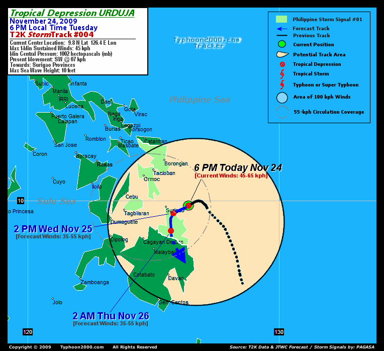
TROPICAL DEPRESSION URDUJA [27W]
T2K PUBLIC ADVISORY NUMBER 005
6:00 PM PST (10:00 GMT) Tue 24 November 2009
Source: T2K Analysis & JTWC Warning #04/SatFix
View: Advisory Archives (2004-2009)
Tropical Depression URDUJA (27W) losing organization and weakening...drifting southwest closer to Siargao Island. Rainbands still affecting Visayas and Northern Mindanao.
*Residents and visitors along Eastern and Central Visayas should closely monitor the progress of URDUJA.
*Do not use this for life or death decision. This advisory is intended for additional information purposes only. Kindly refer to your country's official weather agency for local warnings, advisories & bulletins.
Current Storm Information
Time/Date: 6:00 PM PST Tue November 24 2009
Location of Center: 9.8º N Lat 126.4º E Lon
Distance 1: 45 km (25 nm) East of Siargao Island
Distance 2: 100 km (55 nm) East of Surigao City
Distance 3: 225 km (122 nm) SE of Tacloban City
Distance 4: 240 km (130 nm) SE of Ormoc City
MaxWinds (1-min avg): 45 kph (25 kts) near the center
Peak Wind Gusts: 65 kph (35 kts)
6-hr Rain Amounts (near the center): 250 mm
Minimum Central Pressure: 1002 millibars (hPa)
Saffir-Simpson Typhoon Scale: TD
Present Movement: SW @ 07 kph (04 kts)
Towards: Surigao Provinces
Size (in Diameter): 250 km (135 nm) / Small
Max Sea Wave Height (near center): 10 ft (3.0 m)
Coastal Storm Surge Height: 0 feet [0 m]
T2K TrackMap #04 (for Public): 6 PM PST Tue Nov 24
+ Forecast Outlook: URDUJA is expected to slow down and track SW to Southward into Surigao del Norte. The 1-day Short-Range Forecast shows the system moving overland across Surigao del Norte by tomorrow afternoon (2PM Nov 25: 9.5N 125.8E) and will dissipate into a Tropical Disturbance (LPA). Complete dissipation of this system is forecast by early Thursday morning while over the mountains of Agusan Del Norte. Please be reminded that the Forecast Outlook changes every 6 hours, so a turn to the left or right of its future track and other possibilities must be considered.
+ Effects & Hazards: URDUJA's rainbands remain sheared to the west and continues to dump scattered to widespread rains across Northern Mindanao and the whole of the Visayas. 6-hr total rainfall amounts of 2 up to 75 mm (light to heavy rain) can be expected along the outer bands...with isolated amounts of 250 mm (very heavy to extreme rain) off its inner bands especially over the islands of Leyte, Bohol, Cebu and Negros. Click here to view the latest NOAA's eTRaP graphic on the storm's rainfall amount. Residents in low-lying areas & steep slopes must remain alert & seek evacuation for possible life-threatening flash floods, mudslides & landslides due to the anticipated heavy rains brought about by this system. Precautionary measures must be initiated if necessary.
[Important Note: Please keep in mind that the above forecast outlook, effects, current monsoon intensity, & tropical cyclone watch changes every 6 to 12 hrs!]
PHILIPPINE STORM WARNING SIGNAL # ONE (1)
In Effect: BOHOL, LEYTE PROVINCES, CAMOTES ISLAND, BILIRAN, EASTERN SAMAR, WESTERN SAMAR, SURIGAO PROVINCES, AGUSAN DEL NORTE, DINAGAT ISLAND, SIARGAO ISLAND, & CAMIGUIN ISLAND.
The above areas will have rains and winds of not more than 55 kph today. Coastal waters will be moderate to rough.
Residents living along river banks, low-lying and mountainous areas which are under Public Storm Warning Signal Number 1 are alerted against flashfloods, mudflows, mudslides and landslides.
External Links for TD URDUJA (27W)
View NOAA-CIRA's Latest Wind Analysis
JTWC Latest Tracking Chart: wp9309.gif
Zoomed Satellite Pic: NOAA's Near Real-Time
JTWC (US NAVY / AIR FORCE) 12, 24 & 36 HR. FORECAST & REMARKS:
2 AM (18 GMT) 25 NOVEMBER: 9.9N 126.2E / 45-65 KPH (TD) / SSW @ 05 KPH
<<<Typhoon2000.
Get the latest SMS Storm Alerts on URDUJA!
For more details: Text T2K TYPHOON to
2800 (Globe/TM) | Offline (Smart/TNT) | 2288 (Sun)
*only P2.50 (Smart/Globe) / P2.00 (Sun) per msg received.
powered by: Synermaxx
Typhoon2000 (T2K) NEWS (Mon November 23 2009):
Currently issuing 6-hrly Advisories (except 12:00 AM) on TD URDUJA (27W). Meanwhile, our SMS Updates for SMART (216) is currently OFFLINE due to technical problems. Synermaxx and SMART engineers are now fixing the problem which started a few days ago. Please bear with us.
URDUJA (27W) MAX WIND SPEED PER AGENCY:
+ USA (JTWC/1-min avg): 45 km/hr
+ Japan (JMA/10-min avg): 45 km/hr
+ Philippines (PAGASA/10-min avg): 55 km/hr
TROPICAL DEPRESSION URDUJA [27W]
T2K PUBLIC ADVISORY NUMBER 005
6:00 PM PST (10:00 GMT) Tue 24 November 2009
Source: T2K Analysis & JTWC Warning #04/SatFix
View: Advisory Archives (2004-2009)
*Residents and visitors along Eastern and Central Visayas should closely monitor the progress of URDUJA.
*Do not use this for life or death decision. This advisory is intended for additional information purposes only. Kindly refer to your country's official weather agency for local warnings, advisories & bulletins.
Time/Date: 6:00 PM PST Tue November 24 2009
Location of Center: 9.8º N Lat 126.4º E Lon
Distance 1: 45 km (25 nm) East of Siargao Island
Distance 2: 100 km (55 nm) East of Surigao City
Distance 3: 225 km (122 nm) SE of Tacloban City
Distance 4: 240 km (130 nm) SE of Ormoc City
MaxWinds (1-min avg): 45 kph (25 kts) near the center
Peak Wind Gusts: 65 kph (35 kts)
6-hr Rain Amounts (near the center): 250 mm
Minimum Central Pressure: 1002 millibars (hPa)
Saffir-Simpson Typhoon Scale: TD
Present Movement: SW @ 07 kph (04 kts)
Towards: Surigao Provinces
Size (in Diameter): 250 km (135 nm) / Small
Max Sea Wave Height (near center): 10 ft (3.0 m)
Coastal Storm Surge Height: 0 feet [0 m]
T2K TrackMap #04 (for Public): 6 PM PST Tue Nov 24
+ Forecast Outlook: URDUJA is expected to slow down and track SW to Southward into Surigao del Norte. The 1-day Short-Range Forecast shows the system moving overland across Surigao del Norte by tomorrow afternoon (2PM Nov 25: 9.5N 125.8E) and will dissipate into a Tropical Disturbance (LPA). Complete dissipation of this system is forecast by early Thursday morning while over the mountains of Agusan Del Norte. Please be reminded that the Forecast Outlook changes every 6 hours, so a turn to the left or right of its future track and other possibilities must be considered.
+ Effects & Hazards: URDUJA's rainbands remain sheared to the west and continues to dump scattered to widespread rains across Northern Mindanao and the whole of the Visayas. 6-hr total rainfall amounts of 2 up to 75 mm (light to heavy rain) can be expected along the outer bands...with isolated amounts of 250 mm (very heavy to extreme rain) off its inner bands especially over the islands of Leyte, Bohol, Cebu and Negros. Click here to view the latest NOAA's eTRaP graphic on the storm's rainfall amount. Residents in low-lying areas & steep slopes must remain alert & seek evacuation for possible life-threatening flash floods, mudslides & landslides due to the anticipated heavy rains brought about by this system. Precautionary measures must be initiated if necessary.
[Important Note: Please keep in mind that the above forecast outlook, effects, current monsoon intensity, & tropical cyclone watch changes every 6 to 12 hrs!]
PHILIPPINE STORM WARNING SIGNAL # ONE (1)
In Effect: BOHOL, LEYTE PROVINCES, CAMOTES ISLAND, BILIRAN, EASTERN SAMAR, WESTERN SAMAR, SURIGAO PROVINCES, AGUSAN DEL NORTE, DINAGAT ISLAND, SIARGAO ISLAND, & CAMIGUIN ISLAND.
The above areas will have rains and winds of not more than 55 kph today. Coastal waters will be moderate to rough.
Residents living along river banks, low-lying and mountainous areas which are under Public Storm Warning Signal Number 1 are alerted against flashfloods, mudflows, mudslides and landslides.
External Links for TD URDUJA (27W)
View NOAA-CIRA's Latest Wind Analysis
JTWC Latest Tracking Chart: wp9309.gif
Zoomed Satellite Pic: NOAA's Near Real-Time
2 AM (18 GMT) 25 NOVEMBER: 9.9N 126.2E / 45-65 KPH (TD) / SSW @ 05 KPH
2 PM (00 GMT) 25 NOVEMBER: 9.5N 125.8E / 35-55 KPH (LPA) / S @ 07 KPH
2 AM (18 GMT) 26 NOVEMBER: 8.8N 125.7E / 35-55 KPH (LPA) / ... @ .. KPH
2 AM (18 GMT) 26 NOVEMBER: 8.8N 125.7E / 35-55 KPH (LPA) / ... @ .. KPH
REMARKS: 2 PM (06 GMT) TUE 24 NOVEMBER POSITION: 10.0N 126.7E.
*ANIMATED MULTISPECTRAL SATELLITE IMAGERY (MSI)
SHOWS A FULLY EXPOSED LOW LEVEL CIRCULATION CENTER (LLCC) WITH
CONVECTION SHEARED 120 NM TO THE WEST. IN THE PAST SIX HOURS THE
LLCC HAS STARTED TO INCREASE SPEED TOWARDS MINDANAO AND IS CURRENTLY
BEING STEERED AT THE LOWER LEVELS. MSI ALSO SHOWS THE LLCC IS
BECOMING LESS ORGANIZED, THUS THE DECREASE IN INTENSITY FROM THE
PREVIOUS FORECAST. MODEL GUIDANCE CONTINUES TO MAINTAIN A STRONGER
SYSTEM THAT WRAPS SOUTHWARD AND BACK TO THE NORTHEAST, HOWEVER,
BASED ON THE RECENT WEAKENING TREND AND TRACK, THIS SCENARIO SEEMS
LESS LIKELY AS TD 27W APPROACHES MINDANAO. LANDFALL OVER MINDANAO IS
EXPECTED TO CAUSE THE LLCC TO COMPLETELY DISSIPATE BY TAU 36...(more)
____________
PAGASA CURRENT POSITION, MOVEMENT AND INTENSITY (10-min. ave.):
> 4 PM (08 GMT) 24 NOVEMBER: 10.1N 125.6E / East Slowly / 55 kph
:: For the complete PAGASA bulletin, kindly visit their website at:
http://www.pagasa.dost.gov.ph/wb/tcupdate.shtml
_______________________________________________________________________________________________________________________________________
:: For the complete PAGASA bulletin, kindly visit their website at:
http://www.pagasa.
____________
RECENT TYPHOON2000.
________________________
RECENT MTSAT-1R SATELLITE IMAGE:

> Image source: NOAA SATELLITE CENTER
RECENT WUNDERGROUND SATELLITE ANIMATION:

> Image source: Wunderground.com (http://www.wunderground.com/ ) ____________________________________________________________________________________________________________________
> Image source: NOAA SATELLITE CENTER
____________________________________________________________________________________________________________________
RECENT WUNDERGROUND SATELLITE ANIMATION:
> Image source: Wunderground.
LATEST 6 HR. TOTAL RAINFALL AMOUNTS / ENSEMBLE TROPICAL RAINFALL POTENTIAL (eTRaP):

> Image source: NOAA Satellite & Information Service (http://www.ssd.noaa.gov/PS/TROP/etrap.html?storm=27W )____________________________________________________________________________________________________________________
> Image source: NOAA Satellite & Information Service (http://www.ssd.
NOTE:
^ - JTWC commentary remarks (for Meteorologists) from their latest warning.
__________________________________________________________________________________________
>> To know the meteorological terminologies and acronyms used on this update visit the ff:
http://typhoon2000.ph/tcterm.htm
http://www.nhc.noaa.gov/aboutgloss.shtml
http://www.srh.noaa.gov/oun/severewx/glossary.php
http://www.srh.weather.gov/fwd/glossarynation.html
http://www.nhc.noaa.gov/acronyms.shtml
__________________________________________________________________________________________
For the complete details on TD URDUJA (27W)...go visit our website @:
> http://www.typhoon2000.com
> http://www.maybagyo.com
>> To know the meteorological terminologies and acronyms used on this update visit the ff:
http://typhoon2000.
http://www.nhc.
http://www.srh.
http://www.srh.
http://www.nhc.
____________
> http://www.typhoon2
> http://www.maybagyo
Copyright © 2009 Typhoon2000.
__._,_.___
.
__,_._,___

No comments:
Post a Comment