
for Tuesday, 24 November 2009 [1:31 PM PST]


<<<Typhoon2000.com Mobile >>>
Get the latest SMS Storm Alerts on URDUJA!
For more details: Text T2K TYPHOON to
2800 (Globe/TM) | Offline (Smart/TNT) | 2288 (Sun)
*only P2.50 (Smart/Globe) / P2.00 (Sun) per msg received.
powered by: Synermaxx
Typhoon2000 (T2K) NEWS (Mon November 23 2009):
Currently issuing 6-hrly Advisories (except 12:00 AM) on TD URDUJA (27W). Meanwhile, our SMS Updates for SMART (216) is currently OFFLINE due to technical problems. Synermaxx and SMART engineers are now fixing the problem which started a few days ago. Please bear with us.
URDUJA (27W) MAX WIND SPEED PER AGENCY:
+ USA (JTWC/1-min avg): 55 km/hr
+ Japan (JMA/10-min avg): 55 km/hr
+ Philippines (PAGASA/10-min avg): 55 km/hr
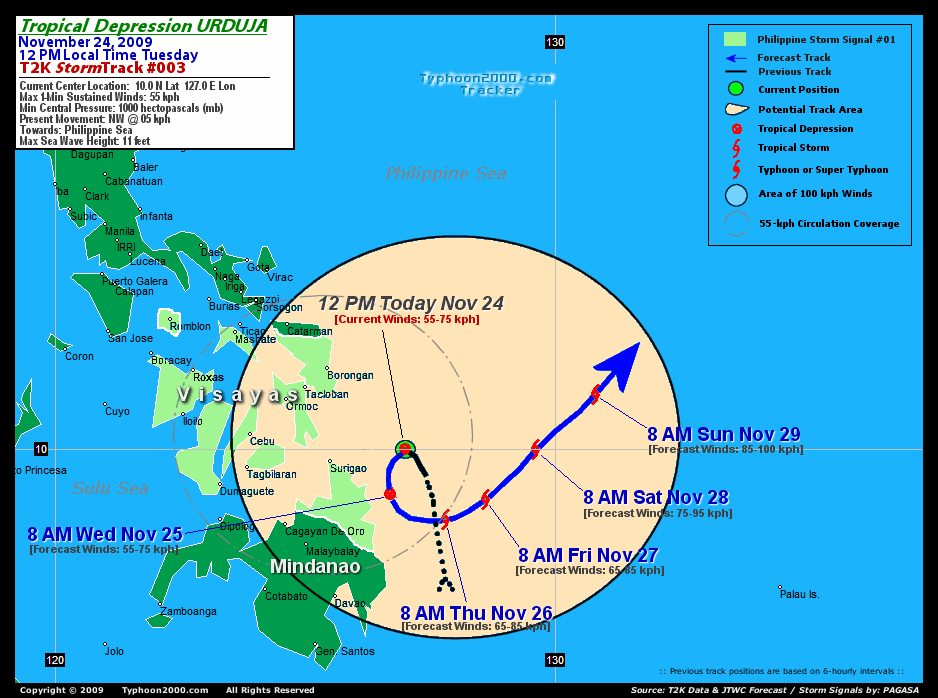
TROPICAL DEPRESSION URDUJA [27W]
T2K PUBLIC ADVISORY NUMBER 004
12:00 PM PST (04:00 GMT) Tue 24 November 2009
Source: T2K Analysis & JTWC Warning #03/SatFix
View: Advisory Archives (2004-2009)
Tropical Depression URDUJA (27W) has been relocated to the east, with its mid-level rainband circulation now over Central Visayas.
*Residents and visitors along Eastern and Central Visayas should closely monitor the progress of URDUJA.
*Do not use this for life/death decision. Kindly refer to your local warnings & bulletins issued by your country's official weather agency. This advisory is intended for additional information purposes only.
Current Storm Information
Time/Date: 12:00 PM PST Tue November 24 2009
Location of Center: 10.0º N Lat 127.0º E Lon
Distance 1: 165 km (90 nm) ENE of Surigao City
Distance 2: 255 km (137 nm) SE of Tacloban City
Distance 3: 285 km (155 nm) ESE of Ormoc City
Distance 4: 340 km (183 nm) ESE of Cebu City
MaxWinds (1-min avg): 55 kph (30 kts) near the center
Peak Wind Gusts: 75 kph (40 kts)
6-hr Rain Amounts (near the center): 230 mm
Minimum Central Pressure: 1000 millibars (hPa)
Saffir-Simpson Typhoon Scale: TD
Present Movement: NW @ 05 kph (03 kts)
Towards: Philippine Sea
Size (in Diameter): 250 km (135 nm) / Small
Max Sea Wave Height (near center): 11 ft (3.3 m)
Coastal Storm Surge Height: 0 feet [0 m]
T2K TrackMap #03 (for Public): 12 PM PST Tue Nov 24
+ Forecast Outlook: URDUJA is expected to slow down and will remain quasi-stationary for the next 12 to 24 hours as it interacts to the much stronger TS NIDA (26W), located South of Guam. The 2 to 5-day Long-Range Forecast shows the system will undergo a counter-clockwise loop passing very near the Northeastern Coast of Mindanao tomorrow morning (8AM Nov 25: 9.1N 126.7E)..and will become a minimal Tropical Storm on Thursday morning (8AM Nov 26: 8.6N 127.8E) as it moves eastward into the Southern Philippine Sea. URDUJA will start tracking NE-ward towards NIDA (26W) starting Friday until Sunday (8AM Nov 27: 9.0N 128.6E...8AM Nov 28: 10.0N 129.6E) and strengthen into a 85-kph tropical storm on Sunday (8AM Nov 29: 11.1N 130.8E). This forecast outlook remains poor in predicting the future path of URDUJA...various computer guidance model are having a hard time positioning this system. Please be reminded that the Forecast Outlook changes every 6 hours, so a turn to the left or right of its future track and other possibilities must be considered.
+ Effects & Hazards: URDUJA's rainbands has been sheared to the west and continues to dump scattered to widespread rains across Northern Mindanao and the whole of the Visayas. 6-hr total rainfall amounts of 2 up to 75 mm (light to heavy rain) can be expected along the outer bands...with isolated amounts of 250 mm (very heavy to extreme rain) off its inner bands especially over the islands of Leyte, Bohol, Cebu and Negros. Click here to view the latest NOAA's eTRaP graphic on the storm's rainfall amount. Residents in low-lying areas & steep slopes must remain alert & seek evacuation for possible life-threatening flash floods, mudslides & landslides due to the anticipated heavy rains brought about by this system. Precautionary measures must be initiated if necessary.
[Important Note: Please keep in mind that the above forecast outlook, effects, current monsoon intensity, & tropical cyclone watch changes every 6 to 12 hrs!]
PHILIPPINE STORM WARNING SIGNAL # ONE (1)
In Effect: MASBATE, ROMBLON, EASTERN SAMAR, WESTERN SAMAR, BILIRAN, LEYTE, CEBU, CAMOTES IS., BOHOL, NEGROS, AKLAN, CAPIZ, ANTIQUE, ILOILO, GUIMARAS, BORACAY, CAMIGUIN, AGUSAN DEL NORTE, SURIGAO PROVINCES, DINAGAT AND SIARGAO ISLANDS.
The above areas will have rains and winds of not more than 55 kph today. Coastal waters will be moderate to rough.
Residents living along river banks, low-lying and mountainous areas which are under Public Storm Warning Signal Number 1 are alerted against flashfloods, mudflows, mudslides and landslides.
External Links for TD URDUJA (27W)
View NOAA-CIRA's Latest Wind Analysis
JTWC Latest Tracking Chart: wp9309.gif
Zoomed Satellite Pic: NOAA's Near Real-Time
JTWC (US NAVY / AIR FORCE) 12, 24, 48 & 72 HR. FORECAST & REMARKS:
8 PM (12 GMT) 24 NOVEMBER: 9.5N 126.7E / 55-75 KPH (TD) / S @ 04 KPH
<<<Typhoon2000.
Get the latest SMS Storm Alerts on URDUJA!
For more details: Text T2K TYPHOON to
2800 (Globe/TM) | Offline (Smart/TNT) | 2288 (Sun)
*only P2.50 (Smart/Globe) / P2.00 (Sun) per msg received.
powered by: Synermaxx
Typhoon2000 (T2K) NEWS (Mon November 23 2009):
Currently issuing 6-hrly Advisories (except 12:00 AM) on TD URDUJA (27W). Meanwhile, our SMS Updates for SMART (216) is currently OFFLINE due to technical problems. Synermaxx and SMART engineers are now fixing the problem which started a few days ago. Please bear with us.
URDUJA (27W) MAX WIND SPEED PER AGENCY:
+ USA (JTWC/1-min avg): 55 km/hr
+ Japan (JMA/10-min avg): 55 km/hr
+ Philippines (PAGASA/10-min avg): 55 km/hr
TROPICAL DEPRESSION URDUJA [27W]
T2K PUBLIC ADVISORY NUMBER 004
12:00 PM PST (04:00 GMT) Tue 24 November 2009
Source: T2K Analysis & JTWC Warning #03/SatFix
View: Advisory Archives (2004-2009)
*Residents and visitors along Eastern and Central Visayas should closely monitor the progress of URDUJA.
*Do not use this for life/death decision. Kindly refer to your local warnings & bulletins issued by your country's official weather agency. This advisory is intended for additional information purposes only.
Current Storm Information
Time/Date: 12:00 PM PST Tue November 24 2009
Location of Center: 10.0º N Lat 127.0º E Lon
Distance 1: 165 km (90 nm) ENE of Surigao City
Distance 2: 255 km (137 nm) SE of Tacloban City
Distance 3: 285 km (155 nm) ESE of Ormoc City
Distance 4: 340 km (183 nm) ESE of Cebu City
MaxWinds (1-min avg): 55 kph (30 kts) near the center
Peak Wind Gusts: 75 kph (40 kts)
6-hr Rain Amounts (near the center): 230 mm
Minimum Central Pressure: 1000 millibars (hPa)
Saffir-Simpson Typhoon Scale: TD
Present Movement: NW @ 05 kph (03 kts)
Towards: Philippine Sea
Size (in Diameter): 250 km (135 nm) / Small
Max Sea Wave Height (near center): 11 ft (3.3 m)
Coastal Storm Surge Height: 0 feet [0 m]
T2K TrackMap #03 (for Public): 12 PM PST Tue Nov 24
+ Forecast Outlook: URDUJA is expected to slow down and will remain quasi-stationary for the next 12 to 24 hours as it interacts to the much stronger TS NIDA (26W), located South of Guam. The 2 to 5-day Long-Range Forecast shows the system will undergo a counter-clockwise loop passing very near the Northeastern Coast of Mindanao tomorrow morning (8AM Nov 25: 9.1N 126.7E)..and will become a minimal Tropical Storm on Thursday morning (8AM Nov 26: 8.6N 127.8E) as it moves eastward into the Southern Philippine Sea. URDUJA will start tracking NE-ward towards NIDA (26W) starting Friday until Sunday (8AM Nov 27: 9.0N 128.6E...8AM Nov 28: 10.0N 129.6E) and strengthen into a 85-kph tropical storm on Sunday (8AM Nov 29: 11.1N 130.8E). This forecast outlook remains poor in predicting the future path of URDUJA...various computer guidance model are having a hard time positioning this system. Please be reminded that the Forecast Outlook changes every 6 hours, so a turn to the left or right of its future track and other possibilities must be considered.
+ Effects & Hazards: URDUJA's rainbands has been sheared to the west and continues to dump scattered to widespread rains across Northern Mindanao and the whole of the Visayas. 6-hr total rainfall amounts of 2 up to 75 mm (light to heavy rain) can be expected along the outer bands...with isolated amounts of 250 mm (very heavy to extreme rain) off its inner bands especially over the islands of Leyte, Bohol, Cebu and Negros. Click here to view the latest NOAA's eTRaP graphic on the storm's rainfall amount. Residents in low-lying areas & steep slopes must remain alert & seek evacuation for possible life-threatening flash floods, mudslides & landslides due to the anticipated heavy rains brought about by this system. Precautionary measures must be initiated if necessary.
[Important Note: Please keep in mind that the above forecast outlook, effects, current monsoon intensity, & tropical cyclone watch changes every 6 to 12 hrs!]
PHILIPPINE STORM WARNING SIGNAL # ONE (1)
In Effect: MASBATE, ROMBLON, EASTERN SAMAR, WESTERN SAMAR, BILIRAN, LEYTE, CEBU, CAMOTES IS., BOHOL, NEGROS, AKLAN, CAPIZ, ANTIQUE, ILOILO, GUIMARAS, BORACAY, CAMIGUIN, AGUSAN DEL NORTE, SURIGAO PROVINCES, DINAGAT AND SIARGAO ISLANDS.
The above areas will have rains and winds of not more than 55 kph today. Coastal waters will be moderate to rough.
Residents living along river banks, low-lying and mountainous areas which are under Public Storm Warning Signal Number 1 are alerted against flashfloods, mudflows, mudslides and landslides.
External Links for TD URDUJA (27W)
View NOAA-CIRA's Latest Wind Analysis
JTWC Latest Tracking Chart: wp9309.gif
Zoomed Satellite Pic: NOAA's Near Real-Time
8 PM (12 GMT) 24 NOVEMBER: 9.5N 126.7E / 55-75 KPH (TD) / S @ 04 KPH
8 AM (00 GMT) 25 NOVEMBER: 9.1N 126.7E / 55-75 KPH (TD) / SSE @ 05 KPH
8 AM (00 GMT) 26 NOVEMBER: 8.6N 127.8E / 65-85 KPH (TS) / ENE @ 04 KPH
8 AM (00 GMT) 27 NOVEMBER: 9.0N 128.6E / 65-85 KPH (TS) / NE @ 07 KPH
8 AM (00 GMT) 26 NOVEMBER: 8.6N 127.8E / 65-85 KPH (TS) / ENE @ 04 KPH
8 AM (00 GMT) 27 NOVEMBER: 9.0N 128.6E / 65-85 KPH (TS) / NE @ 07 KPH
REMARKS: 8 AM (00 GMT) TUE 24 NOVEMBER POSITION: 9.7N 127.1E.
*TROPICAL DEPRESSION (TD) 27W (TWENTYSEVEN)
APPROXIMATELY 55 NM EAST-NORTHEAST OF MINDINAO, HAS TRACKED
NORTHWESTWARD AT 03 KNOTS OVER THE PAST SIX HOURS. ANIMATED
MULTISPECTRAL SATELLITE IMAGERY DEPICTS A FULLY-EXPOSED LOW-LEVEL
CIRCULATION CENTER (LLCC) WITH CONVECTION SHEARED 50 NM TO THE
NORTH. THEREFORE, THERE IS HIGH CONFIDENCE IN BOTH POSITIONING AND
MOTION. THE CURRENT INTENSITY IS BASED ON DVORAK ESTIMATES OF 30-35
KNOTS. ANIMATED WATER VAPOR IMAGERY DEPICTS RESTRICTED OUTFLOW OVER
THE EASTERN SEMI-CIRCLE WITH WEAK POLEWARD OUTFLOW...
____________
PAGASA CURRENT POSITION, MOVEMENT AND INTENSITY (10-min. ave.):
> 10 AM (02 GMT) 24 NOVEMBER: 10.6N 124.9E / WNW Slowly / 55 kph
:: For the complete PAGASA bulletin, kindly visit their website at:
http://www.pagasa.dost.gov.ph/wb/tcupdate.shtml
_______________________________________________________________________________________________________________________________________
:: For the complete PAGASA bulletin, kindly visit their website at:
http://www.pagasa.
____________
RECENT TYPHOON2000.
________________________
RECENT MTSAT-1R SATELLITE IMAGE:

> Image source: NOAA SATELLITE CENTER
RECENT WUNDERGROUND SATELLITE ANIMATION:

> Image source: Wunderground.com (http://www.wunderground.com/ ) ____________________________________________________________________________________________________________________
> Image source: NOAA SATELLITE CENTER
____________________________________________________________________________________________________________________
RECENT WUNDERGROUND SATELLITE ANIMATION:
> Image source: Wunderground.
LATEST 6-12 HR. TOTAL RAINFALL AMOUNTS / ENSEMBLE TROPICAL RAINFALL POTENTIAL (eTRaP):

> Image source: NOAA Satellite & Information Service (http://www.ssd.noaa.gov/PS/TROP/etrap.html?storm=27W )____________________________________________________________________________________________________________________
> Image source: NOAA Satellite & Information Service (http://www.ssd.
NOTE:
^ - JTWC commentary remarks (for Meteorologists) from their latest warning.
__________________________________________________________________________________________
>> To know the meteorological terminologies and acronyms used on this update visit the ff:
http://typhoon2000.ph/tcterm.htm
http://www.nhc.noaa.gov/aboutgloss.shtml
http://www.srh.noaa.gov/oun/severewx/glossary.php
http://www.srh.weather.gov/fwd/glossarynation.html
http://www.nhc.noaa.gov/acronyms.shtml
__________________________________________________________________________________________
For the complete details on TD URDUJA (27W)...go visit our website @:
> http://www.typhoon2000.com
> http://www.maybagyo.com
>> To know the meteorological terminologies and acronyms used on this update visit the ff:
http://typhoon2000.
http://www.nhc.
http://www.srh.
http://www.srh.
http://www.nhc.
____________
> http://www.typhoon2
> http://www.maybagyo
Copyright © 2009 Typhoon2000.
__._,_.___
.
__,_._,___

No comments:
Post a Comment