
for Monday, 23 November 2009 [12:04 PM PST]


<<<Typhoon2000.com Mobile >>>
Get the latest SMS Storm Alerts on TD 93W!
For more details: Text T2K TYPHOON to
2800 (Globe/TM) | Offline (Smart/TNT) | 2288 (Sun)
*only P2.50 (Smart/Globe) / P2.00 (Sun) per msg received.
powered by: Synermaxx
Typhoon2000 (T2K) NEWS (Mon November 23 2009):
Now issuing 6-hrly Advisories (except 12:00 AM) on TD 93W (UNNAMED). Meanwhile, our SMS Updates for SMART (216) is currently OFFLINE due to technical problems. Synermaxx and SMART engineers are now fixing the problem which started a few days ago. Please bear with us.
93W (UNNAMED) MAX WIND SPEED PER AGENCY:
+ USA (JTWC/1-min avg): 40 km/hr
+ Japan (JMA/10-min avg): 55 km/hr
TROPICAL DEPRESSION 93W [UNNAMED]
T2K PUBLIC ADVISORY NUMBER 001
12:00 PM PST (04:00 GMT) Mon 23 November 2009
Source: T2K Analysis & NOAA/JTWC SatFix
View: Advisory Archives (2004-2009)
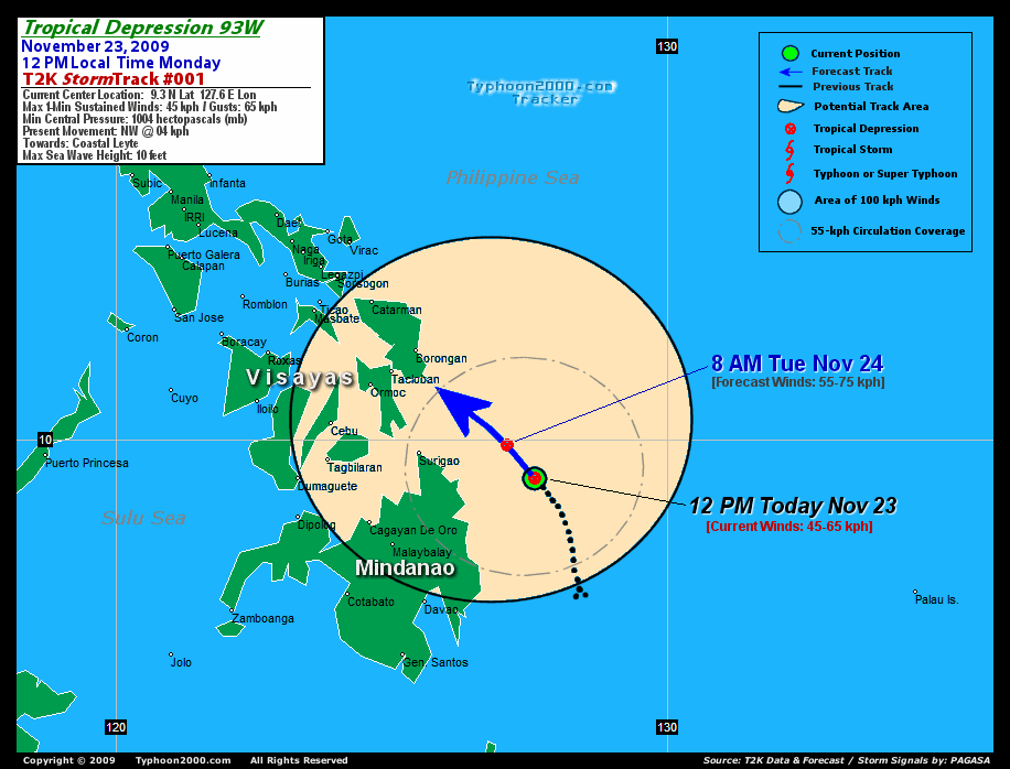
The strong tropical disturbance (LPA) which has been meandering over the Southern Philippine Sea, near the east coast of Mindanao during the past 3 days - has been upgraded to Tropical Depression 93W (UNNAMED). This system has drifted Northwestward during the past 3 hours...may threaten the eastern coasts of Surigao Del Norte, Leyte & Samar.
*Residents and visitors along Eastern and Central Visayas should closely monitor the progress of 93W.
*Kindly refer to your local warnings & bulletins issued by your country's official weather agency. This advisory is intended for additional information purposes only.
Current Storm Information
Time/Date: 12:00 PM PST Mon November 23 2009
Location of Center: 9.3º N Lat 127.6º E Lon
Distance 1: 235 km (128 nm) ESE of Surigao City
Distance 2: 360 km (195 nm) SE of Tacloban City
Distance 3: 290 km (157 nm) SE of Guiuan, E.Samar
MaxWinds (1-min avg): 45 kph (25 kts) near the center
Peak Wind Gusts: 65 kph (35 kts)
6-hr Rain Amounts (near the center): 200 mm
Minimum Central Pressure: 1004 millibars (hPa)
Saffir-Simpson Typhoon Scale: TD
Present Movement: NW @ 04 kph (02 kts)
Towards: Coastal Leyte
Size (in Diameter): 250 km (135 nm) / Small
Max Sea Wave Height (near center): 10 ft (3.0 m)
Coastal Storm Surge Height: 0 feet [0 m]
T2K TrackMap #01 (for Public): 12 PM PST Mon Nov 23
+ Forecast Outlook: 93W is expected to continue drifting NW-ward and slightly intensify. The 1-day Short-Range Forecast shows the system slowing down again while nearing the coast of Leyte & Surigao Del Norte. More forecast outlook will be issued soon as majority of the forecast guidance models remains poor in initializing the future track of this depression. Please be reminded that the Forecast Outlook changes every 6 hours, so a turn to the left or right of its future track and other possibilities must be considered.
+ Effects & Hazards: 93W's organizing bands continues to dump scattered to widespread rains across Northern Mindanao including the coastal areas of Leyte and Samar Islands. Rainfall amounts of up to 200 mm (heavy rains) can be expected. Residents in low-lying areas & steep slopes must remain alert & seek evacuation for possible life-threatening flash floods, mudslides & landslides due to the anticipated heavy rains brought about by this system. Precautionary measures must be initiated if necessary.
[Important Note: Please keep in mind that the above forecast outlook, effects, current monsoon intensity, & tropical cyclone watch changes every 6 to 12 hrs!]
External Links for TD 93W (Unnamed)
View NOAA-CIRA's Latest Wind Analysis
JTWC Latest Tracking Chart: wp9309.gif
Zoomed Satellite Pic: NOAA's Near Real-Time
__________________________________________________________________________________________________________________________________________________________
RECENT TYPHOON2000.COM TRACKING CHART :
<<<Typhoon2000.
Get the latest SMS Storm Alerts on TD 93W!
For more details: Text T2K TYPHOON to
2800 (Globe/TM) | Offline (Smart/TNT) | 2288 (Sun)
*only P2.50 (Smart/Globe) / P2.00 (Sun) per msg received.
powered by: Synermaxx
Typhoon2000 (T2K) NEWS (Mon November 23 2009):
Now issuing 6-hrly Advisories (except 12:00 AM) on TD 93W (UNNAMED). Meanwhile, our SMS Updates for SMART (216) is currently OFFLINE due to technical problems. Synermaxx and SMART engineers are now fixing the problem which started a few days ago. Please bear with us.
93W (UNNAMED) MAX WIND SPEED PER AGENCY:
+ USA (JTWC/1-min avg): 40 km/hr
+ Japan (JMA/10-min avg): 55 km/hr
TROPICAL DEPRESSION 93W [UNNAMED]
T2K PUBLIC ADVISORY NUMBER 001
12:00 PM PST (04:00 GMT) Mon 23 November 2009
Source: T2K Analysis & NOAA/JTWC SatFix
View: Advisory Archives (2004-2009)
*Residents and visitors along Eastern and Central Visayas should closely monitor the progress of 93W.
*Kindly refer to your local warnings & bulletins issued by your country's official weather agency. This advisory is intended for additional information purposes only.
Current Storm Information
Time/Date: 12:00 PM PST Mon November 23 2009
Location of Center: 9.3º N Lat 127.6º E Lon
Distance 1: 235 km (128 nm) ESE of Surigao City
Distance 2: 360 km (195 nm) SE of Tacloban City
Distance 3: 290 km (157 nm) SE of Guiuan, E.Samar
MaxWinds (1-min avg): 45 kph (25 kts) near the center
Peak Wind Gusts: 65 kph (35 kts)
6-hr Rain Amounts (near the center): 200 mm
Minimum Central Pressure: 1004 millibars (hPa)
Saffir-Simpson Typhoon Scale: TD
Present Movement: NW @ 04 kph (02 kts)
Towards: Coastal Leyte
Size (in Diameter): 250 km (135 nm) / Small
Max Sea Wave Height (near center): 10 ft (3.0 m)
Coastal Storm Surge Height: 0 feet [0 m]
T2K TrackMap #01 (for Public): 12 PM PST Mon Nov 23
+ Forecast Outlook: 93W is expected to continue drifting NW-ward and slightly intensify. The 1-day Short-Range Forecast shows the system slowing down again while nearing the coast of Leyte & Surigao Del Norte. More forecast outlook will be issued soon as majority of the forecast guidance models remains poor in initializing the future track of this depression. Please be reminded that the Forecast Outlook changes every 6 hours, so a turn to the left or right of its future track and other possibilities must be considered.
+ Effects & Hazards: 93W's organizing bands continues to dump scattered to widespread rains across Northern Mindanao including the coastal areas of Leyte and Samar Islands. Rainfall amounts of up to 200 mm (heavy rains) can be expected. Residents in low-lying areas & steep slopes must remain alert & seek evacuation for possible life-threatening flash floods, mudslides & landslides due to the anticipated heavy rains brought about by this system. Precautionary measures must be initiated if necessary.
[Important Note: Please keep in mind that the above forecast outlook, effects, current monsoon intensity, & tropical cyclone watch changes every 6 to 12 hrs!]
External Links for TD 93W (Unnamed)
View NOAA-CIRA's Latest Wind Analysis
JTWC Latest Tracking Chart: wp9309.gif
Zoomed Satellite Pic: NOAA's Near Real-Time
____________
RECENT TYPHOON2000.
________________________
RECENT MTSAT-1R SATELLITE IMAGE:

> Image source: NOAA SATELLITE CENTER
RECENT WUNDERGROUND SATELLITE ANIMATION: Not Available!

> Image source: Wunderground.com (http://www.wunderground.com/ ) ____________________________________________________________________________________________________________________
> Image source: NOAA SATELLITE CENTER
____________________________________________________________________________________________________________________
RECENT WUNDERGROUND SATELLITE ANIMATION: Not Available!
> Image source: Wunderground.
LATEST 6-12 HR. TOTAL RAINFALL AMOUNTS / ENSEMBLE TROPICAL RAINFALL POTENTIAL (eTRaP): Not Available!

> Image source: NOAA Satellite & Information Service (http://www.ssd.noaa.gov/PS/TROP/etrap.html )____________________________________________________________________________________________________________________
> Image source: NOAA Satellite & Information Service (http://www.ssd.
NOTE:
^ - JTWC commentary remarks (for Meteorologists) from their latest warning.
__________________________________________________________________________________________
>> To know the meteorological terminologies and acronyms used on this update visit the ff:
http://typhoon2000.ph/tcterm.htm
http://www.nhc.noaa.gov/aboutgloss.shtml
http://www.srh.noaa.gov/oun/severewx/glossary.php
http://www.srh.weather.gov/fwd/glossarynation.html
http://www.nhc.noaa.gov/acronyms.shtml
__________________________________________________________________________________________
For the complete details on TD 26W (UNNAMED)...go visit our website @:
> http://www.typhoon2000.com
> http://www.maybagyo.com
>> To know the meteorological terminologies and acronyms used on this update visit the ff:
http://typhoon2000.
http://www.nhc.
http://www.srh.
http://www.srh.
http://www.nhc.
____________
>
> http://www.maybagyo
Copyright © 2009 Typhoon2000.
__._,_.___
.
__,_._,___

No comments:
Post a Comment