Typhoon2000 STORM UPDATE #004
Name: TYPHOON CHEBI [QUEENIE/23W/0620]
Issued: 7:00 AM MANILA TIME (23:00 GMT) SAT 11 NOVEMBER 2006
Next Update: 1:00 PM (05:00 GMT) SAT 11 NOVEMBER 2006
Source: JTWC TROPICAL CYCLONE WARNING #008
_______________________________________________________________________
Next Update: 1:00 PM (05:00 GMT) SAT 11 NOVEMBER 2006
Source: JTWC TROPICAL CYCLONE WARNING #008
____________
THE DANGEROUS CATEGORY 4 TYPHOON CHEBI (QUEENIE) HAS MADE
LANDFALL OVER AURORA NEAR CASIGURAN...NOW HEADS FOR CENTRAL
LANDFALL OVER AURORA NEAR CASIGURAN...
AND NORTHERN LUZON.
...ITS TRACK IS VERY SIMILAR TO SUPER TYPHOON CIMARON
(PAENG) WHICH CROSSED THE SAME AREA EXACTLY 2 WEEKS AGO...
ALL INTERESTS IN THE NORTHERN AND CENTRAL LUZON SHOULD
CLOSELY MONITOR THE PROGRESS OF TYPHOON CHEBI.
...ITS TRACK IS VERY SIMILAR TO SUPER TYPHOON CIMARON
(PAENG) WHICH CROSSED THE SAME AREA EXACTLY 2 WEEKS AGO...
ALL INTERESTS IN THE NORTHERN AND CENTRAL LUZON SHOULD
CLOSELY MONITOR THE PROGRESS OF TYPHOON CHEBI.
+ FORECAST OUTLOOK: CHEBI is expected to continue tracking
Westward for the next 12 to 24 hours crossing the provin-
ces of Quirino, Nueva Vizcaya passing some 20 km north of
Pantabangan Dam (CASECNAN Hydro Power Plant) around 7-8 AM
this morning and shall be over Dagupan City at around 1-2
PM this afternoon. Chebi's center is expected to move out
into the South China Sea thru Dasol Bay-Rena Point area,
Pangasinan or along the Western Coast of Luzon after sunset
today (between 6 to 7 PM). The 2 to 5-day long-range fore-
cast (Nov 13 to 16) shows the system moving away from the
Philippines and traversing the South China Sea. This
typhoon shall weaken as it makes its 2nd landfall over
Eastern Vietnam by Thursday early morning Nov 16.
+ EFFECTS: CHEBI's circulation is now over Luzon, with its
core (eye + eyewall) moving across Aurora and Quirino -
bringing typhoon conditions over the area, while its inner
bands spreads across Central & Northern Luzon, where rains
and winds of not more than 100 kph can be expected today.
Outer bands affecting Coastal areas of Western Luzon inclu-
ding Metro Manila & Batanes-Calayan Islands and extending
downwards across Northern Bicol. Cloudy conditions associa-
ted with thunderstorms and passing rains w/ winds of not
more than 50 km/hr today. Coastal Storm Surge flooding of
more than 12 to 18 feet above normal tide levels...along
with large and dangerous battering waves can be expected
near and to the north of where the center of CHEBI makes
landfall in Aurora Province today.
outlook, effects & current monsoon intensity, and tropical
cyclone watch changes every 06 to 12 hours!
____________
TIME/DATE: 5:00 AM MANILA TIME (21:00 GMT) 11 NOVEMBER
LOCATION OF EYE: LATITUDE 16.2º N...LONGITUDE 122.1º E
DISTANCE 1: 000 KM (000 NM) OF CASIGURAN, AURORA
DISTANCE 2: 160 KM (85 NM) ESE OF BAGUIO CITY
DISTANCE 3: 195 KM (105 NM) ENE OF DAGUPAN CITY
DISTANCE 4: 210 KM (113 NM) NNE OF METRO MANILA
PEAK WIND GUSTS: 260 KM/HR (140 KTS)
SAFFIR-SIMPSON SCALE: CATEGORY FOUR (4)
MINIMUM CENTRAL PRESSURE (est.): 927 MILLIBARS (hPa)
RECENT MOVEMENT: WEST @ 26 KM/HR (14 KTS)
GENERAL DIRECTION: QUIRINO-NUEVA VIZCAYA
STORM'S SIZE (IN DIAMETER): 520 KM (280 NM)/AVERAGE
MAX WAVE HEIGHT**: 28 FEET (8.5 METERS)
VIEW TRACKING MAP: 5 AM PST SAT NOVEMBER 11
TSR WIND PROBABILITIES: CURRENT TO 120 HRS LEAD
PHILIPPINE STORM SIGNALS*:
#04 - AURORA, QUIRINO & ISABELA.
#03 - ILOCOS SUR, MT. PROVINCE, BENGUET, LA UNION,
KALINGA, IFUGAO, NUEVA VIZCAYA, NUEVA ECIJA,
PANGASINAN, TARLAC, SOUTHERN CAGAYAN, NORTHERN
ZAMBALES, NORTHERN QUEZON, POLILLO ISLAND AND
NORTHERN BULACAN.
#02 - ABRA, APAYAO, ILOCOS NORTE, REST OF CAGAYAN,
PAMPANGA, REST OF ZAMBALES, REST OF BULACAN,
RIZAL, REST OF QUEZON AND CAMARINES NORTE.
#01 - CALAYAN AND BATANES GROUP OF ISLANDS, BATAAN,
CAMARINES SUR, CAVITE, LAGUNA AND METRO MANILA.
12, 24 & 48 HR. FORECAST:
2 PM (06 GMT) 11 NOV: 16.1N 120.4E / 195-240 KPH / W @ 17 KPH
2 AM (18 GMT) 12 NOV: 15.9N 118.6E / 185-230 KPH / W @ 15 KPH
2 AM (18 GMT) 13 NOV: 15.7N 115.3E / 165-205 KPH / W @ 13 KPH
REMARKS: 2 AM (18 GMT) 11 NOVEMBER POSITION: 16.3N 122.7E.
^The storm remains on a rapid westward track along the southern
periphery of a 500 mb steering ridge extending east/west just south
of Taiwan. Some near-term slowing is forecast as the system begins
to interact with Luzon. Although an approaching midlatitude trough
is expected to deepen over eastern China within the next 24 to 36
hours, it is not forecast to break down the ridge currently steering
TY Chebi. Therefore, the storm will remain on a steady track toward
the west or west-southwest after the 24-hour forecast point. TY
Chebi underwent a very rapid intensification cycle between 8 AM and
8 PM Nov 10, and current satellite intensity estimates range from
215 km/hr to 230 km/hr. Nonetheless, the system is now expected
to weaken throughout the forecast period due to a combination of
land interaction, a weakened upper level outflow connection to
the mid-latitude westerlies, and as drier/more stable air is
entrained into the system due to a northeasterly cold surge off
the asian continent..
>> CHEBI {pronounced: je~bi}, meaning: A swallow. A small
bird with long wings and a forked tail that eats insects,
which visits Korea in Spring. Name contributed by:
Republic of Korea.
____________
EYEWALL PASSAGE FORECAST TIMES (EPFT):
+ Aurora-Quirino-
+ Nueva Ecija-Vizcaya: 7AM til 12NN today
+ Pangasinan-La Union: 12NN til 6PM today.
Note: The EyeWall - is the ring of rain clouds surrounding the "EYE" of a Typhoon.
It is here where the strongest winds and heaviest rain of a typhoon can be found.
EPFT will show what local times on a given area the most damaging winds and
heaviest rainfall could be experienced. EPFT changes everytime a new warning
synopsis is issued. Important: This is only an estimate analysis, do not use this
for life or death decisions.
____________
PAGASA CURRENT POSITION, MOVEMENT AND INTENSITY (10-min. ave.):
> 4 AM (20 GMT) 11 NOVEMBER: 16.4N 122.4E / W @ 22 KPH / 195 kph
:: For the complete PAGASA bulletin, kindly visit their website
at: http://www.pagasa.dost.gov.ph/wb/tcupdate.shtml
:: For the complete PAGASA bulletin, kindly visit their website
at: http://www.pagasa.
_______________________________________________________________________
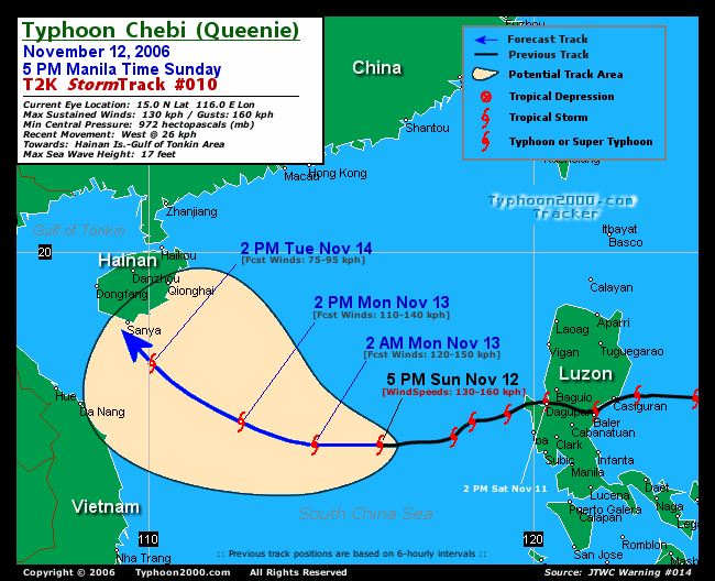
RECENT T2K TRACKING CHART:

________________________
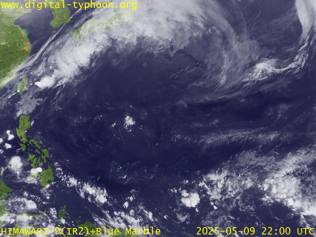
RECENT MTSAT-1R SATELLITE IMAGE:

> Image source: Digital-Typhoon.org (Nat'l. Institute of Informatics) (http://www.digital-typhoon.org )
__________________________________________________________________________________________
NOTES:

> Image source: Digital-Typhoon.
^ - JTWC commentary remarks (for Meteorologists) from their
latest warning.
latest warning.
* - Based on PAGASA's Philippine Storm Warning Signals,
# 4 being the highest. Red bold letters indicate new
areas being hoisted. For more explanations on these
signals, visit: http://www.typhoon2000.ph/signals.htm
** - Based on the Tropical Cyclone's Wave Height near
its center.
__________________________________________________________________________________________
>> To know the meteorological terminologies and acronyms
used on this update visit the ff:
http://typhoon2000.ph/tcterm.htm
http://www.nhc.noaa.gov/aboutgloss.shtml
http://www.srh.noaa.gov/oun/severewx/glossary.php
http://www.srh.weather.gov/fwd/glossarynation.html
http://www.nhc.noaa.gov/acronyms.shtml
__________________________________________________________________________________________
:: Typhoon2000.com (T2K) Mobile >> Powered by: Synermaxx
Receive the latest storm updates directly to your mobile phones! To know more:
Send T2K HELP to: 2800 (GLOBE & TM) | 216 (SMART & TNT) | 2288 (SUN)
Note: Globe & Smart charges P2.50 per message, while Sun at P2.00.
__________________________________________________________________________________________
For the complete details on TY CHEBI (QUEENIE)...go visit
our website @:
> http://www.typhoon2000.com
> http://www.maybagyo.com
# 4 being the highest. Red bold letters indicate new
areas being hoisted. For more explanations on these
signals, visit: http://www.typhoon2
** - Based on the Tropical Cyclone's Wave Height near
its center.
____________
>> To know the meteorological terminologies and acronyms
used on this update visit the ff:
http://typhoon2000.
http://www.nhc.
http://www.srh.
http://www.srh.
http://www.nhc.
____________
:: Typhoon2000.
Receive the latest storm updates directly to your mobile phones! To know more:
Send T2K HELP to: 2800 (GLOBE & TM) | 216 (SMART & TNT) | 2288 (SUN)
Note: Globe & Smart charges P2.50 per message, while Sun at P2.00.
For the complete details on TY CHEBI (QUEENIE)...
our website @:
> http://www.typhoon2
> http://www.maybagyo
Change settings via the Web (Yahoo! ID required)
Change settings via email: Switch delivery to Daily Digest | Switch format to Traditional
Visit Your Group | Yahoo! Groups Terms of Use | Unsubscribe
SPONSORED LINKS
.
__,_._,___
No comments:
Post a Comment