Typhoon2000 STORM UPDATE #001
Name: TROPICAL STORM DURIAN [24W/0621]
Issued: 1:00 PM MANILA TIME (05:00 GMT) SUN 26 NOVEMBER 2006
Next Update: 7:00 PM (11:00 GMT) SUN 26 NOVEMBER 2006
Source: JTWC TROPICAL CYCLONE WARNING #002
_______________________________________________________________________
Next Update: 7:00 PM (11:00 GMT) SUN 26 NOVEMBER 2006
Source: JTWC TROPICAL CYCLONE WARNING #002
____________
NEWLY-FORMED TROPICAL DEPRESSION DURIAN (24W) RAPIDLY BECOMES
A TROPICAL STORM...HEADS FOR THE PHILIPPINES WITH A POTENTIAL
SUPER TYPHOON STRENGTH...SAMAR, BICOL AND QUEZON INCLUDING
AURORA IN SERIOUS THREAT.
...All interests in the Samar, Bicol and Quezon Provinces
should closely monitor the progress of this potential typhoon.
The Philippine local disaster units must be on alert status
beginning tomorrow, Monday as this system might become a dange-
rous Typhoon similar to Super Typhoons ANGELA (ROSING) [Nov 3,
1995] & NINA (SISANG) [Nov 26, 1987].
+ FORECAST OUTLOOK: DURIAN is expected to accelerate WNW and
intensify further into a Typhoon within the next 24 to 48 hours.
It is likely to enter the Philippine Area of Responsibility (PAR)
Tuesday morning, Nov 28. The 3 to 5-day (Nov 29-Dec 01) Long-range
forecast shows the system growing into an extremely dangerous Ca-
tegory 4 Super Typhoon (240 km/hr), passing to the North of Bicol
Region (approx 100 km North of Catanduanes) Thursday morning, Nov
30. This system shall approach the Eastern Coast of Northern Que-
zon Friday morning (8 AM Dec 01) at Category 5 with projected wind
speed of 250 km/hr.
+ EFFECTS: The storm's northern circulation continues affecting
the Southern Mariana Islands including Guam. Passing showers accom-
panied with gale-force winds to prevail across the islands today.
Improving weather conditions shall be expected tomorrow as the
storm moves away from the area.
outlook, effects & current monsoon intensity, and tropical
cyclone watch changes every 06 to 12 hours!
____________
TIME/DATE: 11:00 AM MANILA TIME (03:00 GMT) 26 NOVEMBER
LOCATION OF CENTER: LATITUDE 9.4º N...LONGITUDE 143.9º E
DISTANCE 1: 455 KM (245 NM) SSW OF HAGATNA, GUAM, CNMI
DISTANCE 2: 635 KM (345 NM) EAST OF COLONIA, YAP, FSM
DISTANCE 3: 2,035 KM (1,100 NM) ESE OF BORONGAN, E. SAMAR
DISTANCE 4: 2,185 KM (1,180 NM) ESE OF VIRAC, CATANDUANES
PEAK WIND GUSTS: 85 KM/HR (45 KTS)
SAFFIR-SIMPSON SCALE: N/A
MINIMUM CENTRAL PRESSURE (est.): 997 MILLIBARS (hPa)
RECENT MOVEMENT: WNW @ 20 KM/HR (11 KTS)
GENERAL DIRECTION: PHILIPPINE SEA
STORM'S SIZE (IN DIAMETER): 300 KM (160 NM)/SMALL
MAX WAVE HEIGHT**: 18 FEET (5.4 METERS)
VIEW TRACKING MAP: 11 AM PST SUN NOVEMBER 26
TSR WIND PROBABILITIES: CURRENT TO 120 HRS LEAD
PHILIPPINE STORM SIGNALS*: N/A
12, 24 & 48 HR. FORECAST:
8 PM (12 GMT) 26 NOV: 10.0N 142.2E / 85-100 KPH / WNW @ 19 KPH
8 AM (00 GMT) 27 NOV: 10.8N 140.3E / 110-140 KPH / WNW @ 20 KPH
8 AM (00 GMT) 28 NOV: 12.5N 135.6E / 175-215 KPH / WNW @ 24 KPH
REMARKS: 8 AM (00 GMT) 26 NOVEMBER POSITION: 9.2N 144.4E.
^ANIMATED MULTISPECTRAL SATELLITE IMAGERY INDICATES THAT THE
SYSTEM HAS CONSOLIDATED QUICKLY OVER THE PAST 12 HOURS. A
MICROWAVE IMAGE DEPICTS IMPROVED DEEP CONVECTIVE BANDING OVER
THE NORTHERN AND EASTERN SEMICIRCLES AND BETTER ORGANIZATION
OF THE LOW LEVEL CIRCULATION CENTER...(more info)
>> DURIAN {pronounced: door~yan}, meaning: Favourite fruit of
Thai people (Durio zibethinus). Name contributed by: Thailand.
____________
_______________________________________________________________________
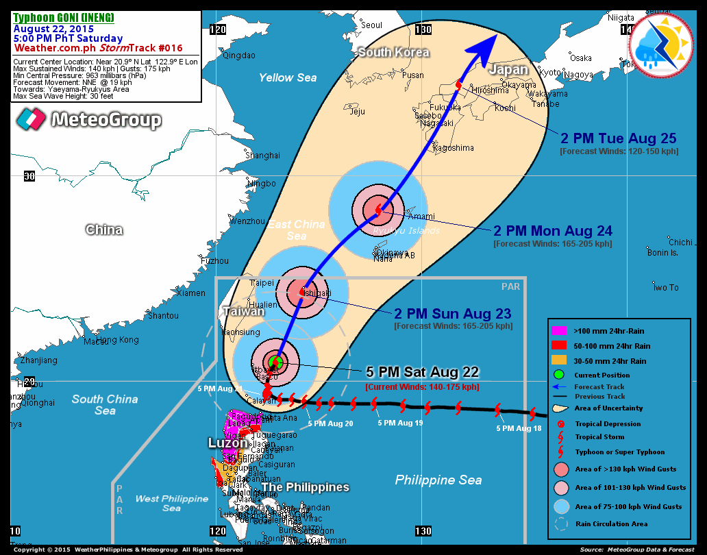
RECENT T2K TRACKING CHART:

________________________
RECENT MTSAT-1R SATELLITE IMAGE:

> Image source: Digital-Typhoon.org (Nat'l. Institute of Informatics) (http://www.digital-typhoon.org )
__________________________________________________________________________________________
NOTES:

> Image source: Digital-Typhoon.
^ - JTWC commentary remarks (for Meteorologists) from their
latest warning.
latest warning.
* - Based on PAGASA's Philippine Storm Warning Signals,
# 4 being the highest. Red letters indicate new areas
being hoisted. For more explanations on these signals,
visit: http://www.typhoon2000.ph/signals.htm
** - Based on the Tropical Cyclone's Wave Height near
its center.
__________________________________________________________________________________________
>> To know the meteorological terminologies and acronyms
used on this update visit the ff:
http://typhoon2000.ph/tcterm.htm
http://www.nhc.noaa.gov/aboutgloss.shtml
http://www.srh.noaa.gov/oun/severewx/glossary.php
http://www.srh.weather.gov/fwd/glossarynation.html
http://www.nhc.noaa.gov/acronyms.shtml
__________________________________________________________________________________________
:: Typhoon2000.com (T2K) Mobile >> Powered by: Synermaxx
Receive the latest storm updates directly to your mobile phones! To know more:
Send T2K HELP to: 2800 (GLOBE & TM) | 216 (SMART & TNT) | 2288 (SUN)
Note: Globe & Smart charges P2.50 per message, while Sun at P2.00.
__________________________________________________________________________________________
For the complete details on TS DURIAN (24W)...go visit
our website @:
> http://www.typhoon2000.com
> http://www.maybagyo.com
# 4 being the highest. Red letters indicate new areas
being hoisted. For more explanations on these signals,
visit: http://www.typhoon2
** - Based on the Tropical Cyclone's Wave Height near
its center.
____________
>> To know the meteorological terminologies and acronyms
used on this update visit the ff:
http://typhoon2000.
http://www.nhc.
http://www.srh.
http://www.srh.
http://www.nhc.
____________
:: Typhoon2000.
Receive the latest storm updates directly to your mobile phones! To know more:
Send T2K HELP to: 2800 (GLOBE & TM) | 216 (SMART & TNT) | 2288 (SUN)
Note: Globe & Smart charges P2.50 per message, while Sun at P2.00.
For the complete details on TS DURIAN (24W)...go visit
our website @:
> http://www.typhoon2
> http://www.maybagyo
Change settings via the Web (Yahoo! ID required)
Change settings via email: Switch delivery to Daily Digest | Switch format to Traditional
Visit Your Group | Yahoo! Groups Terms of Use | Unsubscribe
SPONSORED LINKS
.
__,_._,___
No comments:
Post a Comment