Typhoon2000 STORM UPDATE #002
Name: TROPICAL STORM TRAMI [26W/0623]
Issued: 7:00 AM MANILA TIME (23:00 GMT) MON 18 DECEMBER 2006
Next Update: 7:00 PM (11:00 GMT) MON 18 DECEMBER 2006
Source: JTWC TROPICAL CYCLONE WARNING #004
Next Update: 7:00 PM (11:00 GMT) MON 18 DECEMBER 2006
Source: JTWC TROPICAL CYCLONE WARNING #004
_______________________________________________________________________
TROPICAL DEPRESSION TRAMI (26W) HAS MAINTAINED ITS
NORTHWESTERLY TRACK ACROSS THE PHILIPPINE SEA...
EXPECTED TO ENTER THE PHILIPPINE AREA OF RESPON-
SIBILITY (PAR) THIS AFTERNOON.
...Japan Meteorological Agency (JMA) analyzed TRAMI as a
65-km/hr Tropical Storm, with the same forecast as JTWC.
All interests in the Luzon area should closely monitor
the progress of TD TRAMI.
+ FORECAST OUTLOOK: The forecast of TD TRAMI has changed
dramatically wuth a possible threat to Extreme Northern
Luzon. TRAMI is now expected to turn WNW to West and
enter the PAR within the next 12 hours and shall be
named by PAGASA as "TOMAS". The 2 to 3-day medium range
forecast shows the system becoming a Tropical Storm as
it moves towards the Extreme Northern Luzon. It shall
briefly become a 120-km/hr Typhoon before returning back
to Tropical Storm as it approaches the eastern coast of
Cagayan by early Thursday morning (Dec 21). Two other
scenarios are possible: The first scenario shows the
depression dipping to a WSW track towards Bicol-Quezon
area, while the second scenario recurves TRAMI towards
Southern Japan after being captured by the exiting frontal
system off Japan. Please be aware that these forecasts
changes every 6 hours. So, kindly watch out for our
succeeding advisories.
+ EFFECTS: This system is not yet affecting any Pacific
Islands.
+ CURRENT MONSOON INTENSITY: A surge of moderate to strong
Northeast Monsoon currently prevailing across Luzon bringing
cloudy skies with occasional light to moderate rains and
cooler winds of 30-60 km/hr winds becoming more frequent
across Batanes, Northeastern Luzon, Quezon, Bicol Region
& Northern Samar.
Important Note: Please keep in mind that the above forecast
outlook, effects & current monsoon intensity, and tropical
cyclone watch changes every 06 to 12 hours!
____________
TIME/DATE: 5:00 AM MANILA TIME (21:00 GMT) 18 DECEMBER
LOCATION OF CENTER: LATITUDE 14.8º N...LONGITUDE 136.7º E
DISTANCE 1: 1,345 KM (725 NM) ENE OF VIRAC, CATANDUANES
DISTANCE 2: 185 KM (100 NM) EAST OF PAR
DISTANCE 3: 1,415 KM (765 NM) ENE OF LEGAZPI CITY
DISTANCE 4: 1,460 KM (790 NM) ENE OF NAGA CITY
DISTANCE 5: 1,610 KM (870 NM) EAST OF INFANTA, QUEZON
DISTANCE 6: 1,570 KM (848 NM) ESE OF CASIGURAN, AURORA
DISTANCE 5: 1,610 KM (870 NM) EAST OF INFANTA, QUEZON
DISTANCE 6: 1,570 KM (848 NM) ESE OF CASIGURAN, AURORA
PEAK WIND GUSTS: 75 KM/HR (40 KTS)
SAFFIR-SIMPSON SCALE: N/A
MINIMUM CENTRAL PRESSURE (est.): 1000 MILLIBARS (hPa)
RECENT MOVEMENT: NW @ 28 KM/HR (15 KTS)
GENERAL DIRECTION: PHILIPPINE SEA
STORM'S SIZE (IN DIAMETER): 370 KM (200 NM)/AVERAGE
MAX WAVE HEIGHT**: 10 FEET (3.0 METERS)
VIEW TRACKING MAP: 5 AM PST MON DECEMBER 18
TSR WIND PROBABILITIES: CURRENT TO 72 HRS LEAD
PHILIPPINE STORM SIGNALS*: N/A
12, 24 & 48 HR. FORECAST:
2 PM (06 GMT) 18 DEC: 16.1N 134.8E / 65-85 KPH / WNW @ 26 KPH
2 AM (18 GMT) 19 DEC: 16.9N 131.9E / 85-100 KPH / W @ 26 KPH
2 AM (18 GMT) 20 DEC: 17.4N 126.4E / 120-150 KPH / WNW @ 15 KPH
12, 24 & 48 HR. FORECAST:
2 PM (06 GMT) 18 DEC: 16.1N 134.8E / 65-85 KPH / WNW @ 26 KPH
2 AM (18 GMT) 19 DEC: 16.9N 131.9E / 85-100 KPH / W @ 26 KPH
2 AM (18 GMT) 20 DEC: 17.4N 126.4E / 120-150 KPH / WNW @ 15 KPH
REMARKS: 2 AM (18 GMT) 18 DECEMBER POSITION: 14.3N 137.3E.
^A AMSR-E IMAGE AND A AMSU-B IMAGE SHOW WEAK LOW CYCLONIC
TURNING, AND HINT AT MULTIPLE LOW LEVEL CIRCULATION
CENTERS. ANIMATED INFRARED SATELLITE IMAGERY CONFIRMS
THIS, AND FURTHER INDICATES STRONG SHEARING OF THE DEEP
CONVECTION FROM THE LOW LEVEL CIRCULATION.
>> TRAMI {pronounced: tra~mee}, meaning: A kind of tree
belonging to the rose family, its flowers are pink or
red without perfume, is used as decorative tree.
Name contributed by: Vietnam.
____________
_______________________________________________________________________
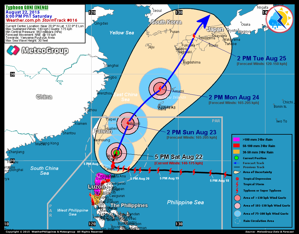
RECENT T2K TRACKING CHART:

________________________
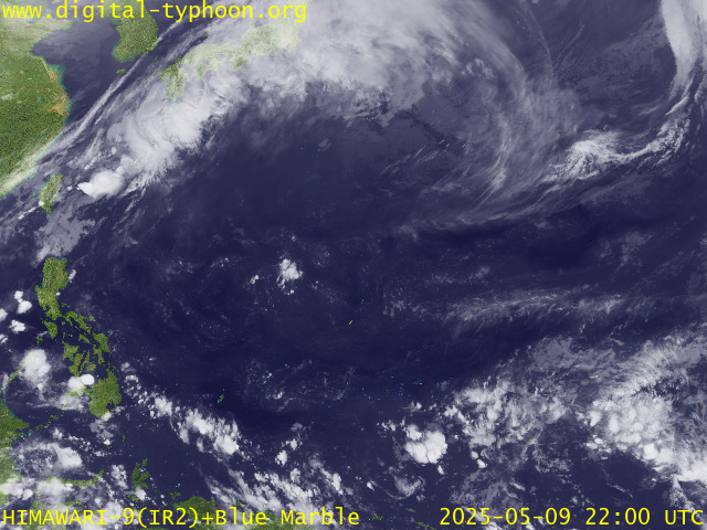
RECENT MTSAT-1R SATELLITE IMAGE:

> Image source: Digital-Typhoon.org (Nat'l. Institute of Informatics) (http://www.digital-typhoon.org )
__________________________________________________________________________________________
NOTES:

> Image source: Digital-Typhoon.
^ - JTWC commentary remarks (for Meteorologists) from their
latest warning.
latest warning.
* - Based on PAGASA's Philippine Storm Warning Signals,
# 4 being the highest. Red letters indicate new areas
being hoisted. For more explanations on these signals,
visit: http://www.typhoon2000.ph/signals.htm
** - Based on the Tropical Cyclone's Wave Height near
its center.
__________________________________________________________________________________________
>> To know the meteorological terminologies and acronyms
used on this update visit the ff:
http://typhoon2000.ph/tcterm.htm
http://www.nhc.noaa.gov/aboutgloss.shtml
http://www.srh.noaa.gov/oun/severewx/glossary.php
http://www.srh.weather.gov/fwd/glossarynation.html
http://www.nhc.noaa.gov/acronyms.shtml
__________________________________________________________________________________________
:: Typhoon2000.com (T2K) Mobile >> Powered by: Synermaxx
Receive the latest storm updates directly to your mobile phones! To know more:
Send T2K HELP to: 2800 (GLOBE & TM) | 216 (SMART & TNT) | 2288 (SUN)
Note: Globe & Smart charges P2.50 per message, while Sun at P2.00.
__________________________________________________________________________________________
For the complete details on TD TRAMI (26W)...go visit
our website @:
> http://www.typhoon2000.com
> http://www.maybagyo.com
# 4 being the highest. Red letters indicate new areas
being hoisted. For more explanations on these signals,
visit: http://www.typhoon2
** - Based on the Tropical Cyclone's Wave Height near
its center.
____________
>> To know the meteorological terminologies and acronyms
used on this update visit the ff:
http://typhoon2000.
http://www.nhc.
http://www.srh.
http://www.srh.
http://www.nhc.
____________
:: Typhoon2000.
Receive the latest storm updates directly to your mobile phones! To know more:
Send T2K HELP to: 2800 (GLOBE & TM) | 216 (SMART & TNT) | 2288 (SUN)
Note: Globe & Smart charges P2.50 per message, while Sun at P2.00.
For the complete details on TD TRAMI (26W)...go visit
our website @:
> http://www.typhoon2
> http://www.maybagyo
Change settings via the Web (Yahoo! ID required)
Change settings via email: Switch delivery to Daily Digest | Switch format to Traditional
Visit Your Group | Yahoo! Groups Terms of Use | Unsubscribe
SPONSORED LINKS
.
__,_._,___
No comments:
Post a Comment