for Wednesday, 06 August 2014 [9:57 AM PhT]
WEATHER.COM.PH TROPICAL CYCLONE UPDATES
TYPHOON HALONG (JOSE) UPDATE NUMBER 007
Issued at: 6:30 AM PhT (22:30 GMT) Wednesday 06 August 2014
Next Update: 6:30 PM PhT (10:30 GMT) Wednesday 06 August 2014
Typhoon HALONG (JOSE) has moved north-northeast during the past 12 hours as it weakened further while over the northeastern part of the Philippine Sea...expected to move out of the Philippine Area of Responsibility (PAR) Thursday morning.
This typhoon will continue to enhance the Southwest Monsoon (Habagat) and bring mostly cloudy and windy conditions with occasional rains and scattered thunderstorms across Western and Central Luzon including Metro Manila today. The threat of flash floods and landslides are likely in hazard-prone areas especially along river banks and mountain slopes of the affected areas especially during the occurrence of severe thunderstorms. Residents are advised to take necessary precautions.
Residents and visitors along Okinawa and Ryukyu Islands, and Southern Japan should closely monitor the development of TY Halong (Jose).
Information based on data collected by WeatherPhilippines Foundation, Inc. shall not be taken as official data. Weather information broadcasted and distributed by PAGASA remains as official data. WeatherPhilippines shall not be responsible for the private use and reliance of its weather information.
CYCLONE HAZARDS AFFECTING LAND
Below are the regions or places in the Philippines that could be affected by the current tropical cyclone.
None.
CURRENT CYCLONE INFORMATION
As of 5:00 AM PhT today...2100 GMT.
Classification/Name: TY Halong (Jose)
Location: Over the northeastern part of the Philippine Sea (near 22.2N 130.3E)
About: 540 km south-southeast of Okinawa, Japan...or 880 km east-northeast of Basco, Batanes
Maximum Sustained Winds (10-min avg): 140 kph near the center...Gustiness: 175 kph
24 hr. Rain Accumulation (near the center): 200 to 400 mm [Heavy to Extreme]
Minimum Central Pressure: 963 millibars (hPa)
Size (in diameter): 835 km (Medium)
Area of Damaging Winds (95 kph or more): 130 kilometers from the center
Past Movement: North-Northeast @ 17 kph
Forecast Movement: North-Northeast @ 13 kph
Towards: Ryukyu Islands
2-DAY FORECAST OUTLOOK*
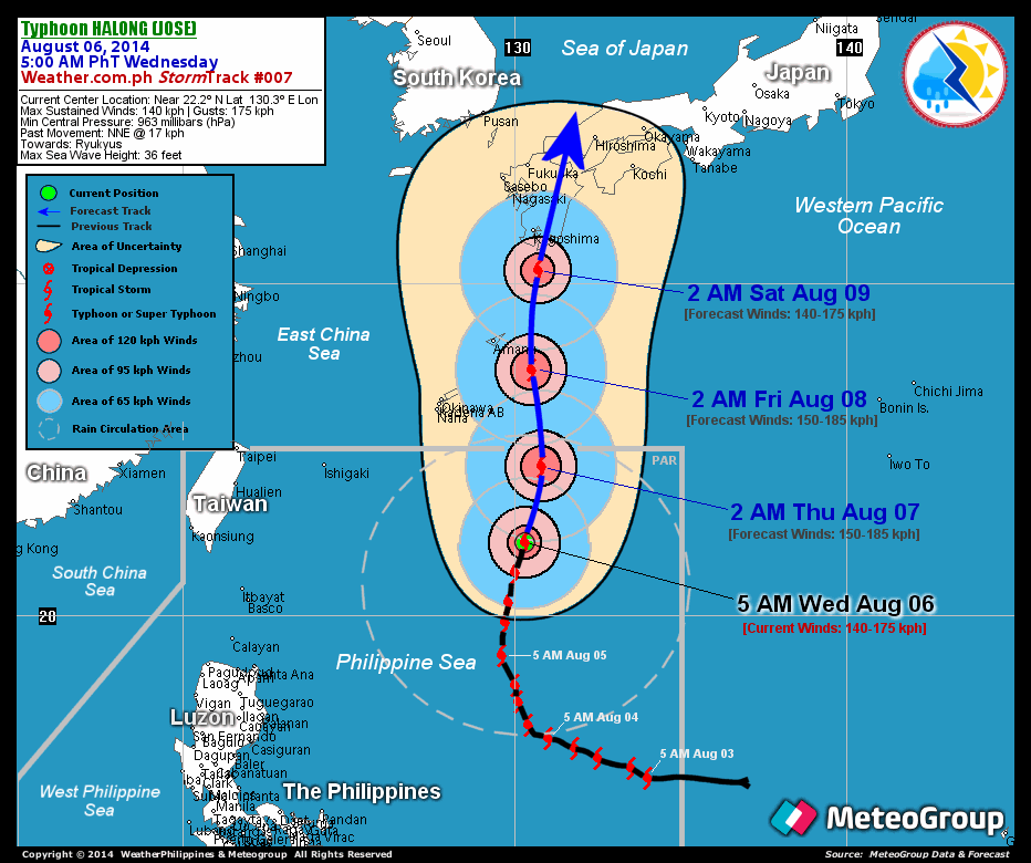
TY Halong (Jose) is expected to continue moving north-northeastward during the next 24 hours...turning north through 48 hours. On the forecast track, Halong (Jose) will just be moving across the open waters of the northernmost part of the Philippine Sea...exiting the Philippine Area of Responsibility (PAR) on Thursday morning as it heads towards Okinawa-Ryukyus Area.
Halong (Jose) will regain a little bit of strength during the next 24 to 48 hours while passing over warmer sea surface temperatures. Advance Intensity Forecast (AIF) shows its 10-minute maximum sustained winds increasing back to 150 kph by early Thursday morning.
The following is the 3-day forecast outlook summary for this system:
THURSDAY EARLY MORNING: Regains a little bit of strength as it moves north towards Eastern Ryukyus...about 375 km southeast of Okinawa, Japan [2AM AUG 07: 24.5N 130.8E @ 150kph].
FRIDAY EARLY MORNING: Maintains its strength as it moves out of the Philippine Area of Responsisbility (PAR)...maintains its northerly track...about 145 km southeast of Amami Is., Japan [2AM AUG 08: 27.4N 130.5E @ 150kph].
SATURDAY EARLY MORNING: Weakens as it bears down the southern coast of Kyushu, Japan...about 135 km south of Kagoshima, Japan [2AM AUG 09: 30.4N 130.7E @ 140kph].
*Please be reminded that the Forecast Outlook changes every 6 hours, and the Day 2 and 3 Forecast Track has an average error of 100 and 250 km respectively...while the wind speed forecast error, averages 35 kph per day. Therefore, a turn to the left or right of its future track and changes in its wind speed must be anticipated from time to time.
Important Note: Please keep in mind that the above hazards summary and forecast outlook changes every 6 to 12 hrs!
ADDITIONAL DISTANCES
Time/Date: 5:00 AM PhT Wed Aug 06, 2014
Location of Eye: Near 22.2º N Lat 130.3º E Lon
Distance 1: 685 km S of Amami Is., Japan
Distance 2: 665 km ESE of Ishigakijima, Japan
Distance 3: 895 km ENE of Itbayat, Batanes
Distance 4: 940 km NE of Santa Ana, Cagayan
Distance 5: 1045 km S of Kagoshima, Japan
Issued by: David Michael V. Padua for Weather.com.ph
CURRENT TRACKING MAP:

__________________________________________________________________________________________________
__________________________________________________________________________________________________
CURRENT NOAA/MTSAT-2 INFRARED (IR) SATELLITE IMAGE:

__________________________________________________________________________________________________
>> To know the meteorological terminologies and acronyms used on this update visit the ff:
http://typhoon2000.ph/tcterm.htm
http://www.nhc.noaa.gov/aboutgloss.shtml
http://www.nhc.noaa.gov/acronyms.shtml
__________________________________________________________________________________________
For the complete details on TY HALONG (JOSE)...go visit our website @:
> http://www.typhoon2000.com
> http://www.maybagyo.com
Copyright © 2014 Typhoon2000.com All Rights Reserved
Posted by: "Typhoon2000.com (Michael V. Padua)" <T2Kstormupdates@gmail.com>
| Reply via web post | • | Reply to sender | • | Reply to group | • | Start a New Topic | • | Messages in this topic () |

No comments:
Post a Comment