Typhoon2000 STORM UPDATE #009
Name: SUPER TYPHOON SEPAT [EGAY/09W/0708]
Issued: 7:00 AM MANILA TIME (23:00 GMT) FRI 17 AUGUST 2007
Next Update: 7:00 PM (11:00 GMT) FRI 17 AUGUST
Source: JTWC TROPICAL CYCLONE WARNING #019
Next Update: 7:00 PM (11:00 GMT) FRI 17 AUGUST
Source: JTWC TROPICAL CYCLONE WARNING #019
_______________________________________________________________________
SUPER TYPHOON SEPAT (EGAY) WEAKENED SLIGHTLY BUT REMAINS AT
CATEGORY FIVE WITH WINDS OF 250 KM/HR...APPROACHING BATANEScommon cycle naturally observed in intense tropical
cyclones (category 3 and up) wherein a new eyewall will
form & replace the current eyewall as it starts decaying.
gory 5 strength for the next 6 hours and starts to weaken.
It shall pass close to the northeast of Batanes Group of
Islands this afternoon and approach the Southeastern Coast
of Taiwan early Saturday morning. SEPAT shall hit land or
make landfall over Southeastern Taiwan at approx 3-4 AM HK
Time and cross the mountainous terrain of south Central
Taiwan. This intense system shall weaken considerably to
Cat 2 or 1 upon moving back to sea Saturday afternoon
(Taiwan Strait). The 2 to 4-day forecast shows SEPAT
making its last landfall over Southeastern China early
Sunday morning (Aug 19) around 3 AM - passing very close
to the northeast of Xiamen City as a weak typhoon (120-
150 km/hr). SEPAT shall dissipate over the mountainous
region of China on Monday, Aug 20.
+ EFFECTS: SEPAT's western outer bands continues to spread
+ EFFECTS: SEPAT's western outer bands continues to spread
across the provinces of Ilocos Norte, Abra, Batanes Group,
Cagayan, & Isabela. Cloudy skies with passing occasionally
light to sometimes heavy rainfall and strong winds of up to
60 km/hr can be expected along these bands. Meanwhile, large
waves can also be observed along the coastline of Eastern
Luzon (from Cagayan down to Bicol Peninsula). Stormy weather
conditions is likely to be felt today over Babuyan and
Batanes Group of Islands as the typhoon's inner spiral bands
approaches. Coastal Storm Surge flooding of more than 20 feet
above normal tide levels...along with large and dangerous
battering waves can be expected near and to the north of
SEPAT's projected path particularly along the Southern and
Eastern Coasts of Taiwan including Extreme Northern Luzon.
Flash floods and mudslides are imminent along river banks,
low-lying and mountainous regions of the affected areas.
Precautionary measures must be initiated as the powerful
system moves closer.
+ CURRENT MONSOON INTENSITY: The Southwest (SW) Monsoon
+ CURRENT MONSOON INTENSITY: The Southwest (SW) Monsoon
continues to be enhanced (pulled) by SEPAT. Cloudy skies with
passing light to moderate to sometimes heavy rains & SW'ly
winds of 20 km/hr or higher can be expected today along Luzon
and Visayas - becoming more frequent over the Western sections
including Metro Manila, Southern Tagalog Provinces, Mindoro,
Calamian Group, Western Panay, Boracay Island Resort, Masbate,
Ticao & Burias Islands, & the Bicol Region. Mudslides and
flooding is likely along river banks, low-lying & flood-prone
areas of the affected areas.
Important Note: Please keep in mind that the above forecast
outlook, effects & current monsoon intensity, and tropical
cyclone watch changes every 06 to 12 hours!
____________
TIME/DATE: 5:00 AM MANILA TIME (21:00 GMT) 17 AUGUST
LOCATION OF EYE: LATITUDE 19.8º N...LONGITUDE 124.4º E
DISTANCE 1: 260 KM (140 NM) ESE OF BASCO, BATANES, PH
DISTANCE 2: 325 KM (175 NM) NE OF APARRI, CAGAYAN, PH
DISTANCE 3: 525 KM (283 NM) SE OF KAOSHIUNG, TAIWAN
DISTANCE 4: 550 KM (297 NM) SE OF HUALIEN, TAIWAN
MAX SUSTAINED WINDS [1-MIN AVG]: 250 KM/HR (135 KTS)DISTANCE 4: 550 KM (297 NM) SE OF HUALIEN, TAIWAN
PEAK WIND GUSTS: 305 KM/HR (165 KTS)
SAFFIR-SIMPSON SCALE: CATEGORY FIVE (5)
MINIMUM CENTRAL PRESSURE (est.): 922 MILLIBARS (hPa)
RECENT MOVEMENT: NW @ 19 KM/HR (10 KTS)
GENERAL DIRECTION: BATANES-TAIWAN AREA
STORM'S SIZE (IN DIAMETER): 815 KM (440 NM)/LARGE
MAX WAVE HEIGHT**: 46 FEET (14.0 METERS)
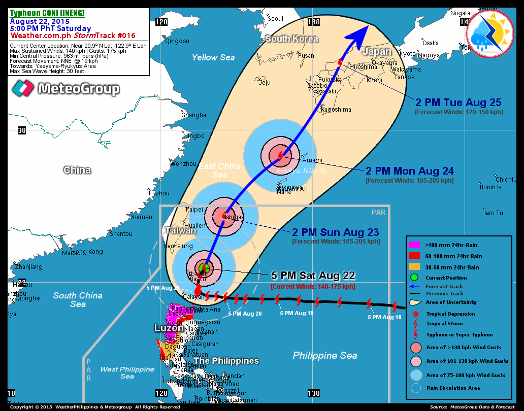
VIEW T2K TRACKING MAP: 5 AM MANILA TIME FRI AUGUST 17
TSR WIND PROBABILITIES: CURRENT TO 96 HRS LEAD
PHILIPPINE STORM SIGNALS*:
#03 - BATANES GROUP OF ISLANDS.
#02 - BABUYAN ISLANDS.
#01 - CAGAYAN, ISABELA, NORTHERN AURORA, KALINGA, APAYAO,
ILOCOS NORTE, & ABRA.
12, 24 & 48 HR. FORECAST:
2 PM (06 GMT) 17 AUGUST: 21.1N 123.3E / 240-295 KPH / NW @ 20 KPH
2 AM (18 GMT) 18 AUGUST: 22.7N 121.7E / 230-280 KPH / NW @ 17 KPH
2 AM (18 GMT) 19 AUGUST: 24.8N 118.9E / 150-185 KPH / WNW @ 13 KPH
REMARKS: 2 AM (18 GMT) 17 AUGUST POSITION: 19.4N 124.8E.
^SUPER TYPHOON (STY) 09W (SEPAT) HAS MAINTAINED ITS STATUS
AS A SUPER TYPHOON DURING THE PAST 12 HOURS UNDER THE IN-
REMARKS: 2 AM (18 GMT) 17 AUGUST POSITION: 19.4N 124.8E.
^SUPER TYPHOON (STY) 09W (SEPAT) HAS MAINTAINED ITS STATUS
AS A SUPER TYPHOON DURING THE PAST 12 HOURS UNDER THE IN-
FLUENCE OF HIGH OCEAN HEAT CONTENT AND GOOD EQUATORWARD
OUTFLOW. THE STORM HAS CONTINUED TO MOVE GENERALLY NORTH-
WESTWARD ON THE SOUTHWESTERN PERIPHERY OF A SUBTROPICAL
HIGH PRESSURE STEERING RIDGE TO THE NORTH AND EAST. THE
CURRENT STORM POSITION ESTIMATE IS BASED ON POSITION FIXES
FROM PGTW AND RJTD AND RECENT MICROWAVE SATELLITE IMAGERY.
A SSMIS MICROWAVE IMAGE DEPICTS A CONCENTRIC EYEWALL IN ITS
FORMATIVE STAGES, SUGGESTING THAT AN EYEWALL REPLACEMENT
CYCLE HAS BEGUN...(more)
>> SEPAT {pronounced: se~pa~t}, meaning: A fresh water fish
with small climbing perch, is often found in rivers, swampy
areas with a lot of weeds and paddy fields. Name contributed
by: Malaysia.
_______________________________________________________________________
PAGASA CURRENT POSITION, MOVEMENT AND INTENSITY (10-min. ave.):
by: Malaysia.
____________
PAGASA CURRENT POSITION, MOVEMENT AND INTENSITY (10-min. ave.):
> 4 AM (20 GMT) 17 AUGUST: 19.7N 124.5E / NW @ 19 KPH / 215 kph
:: For the complete PAGASA bulletin, kindly visit their website
at: http://www.pagasa.dost.gov.ph/wb/tcupdate.shtml
:: For the complete PAGASA bulletin, kindly visit their website
at: http://www.pagasa.
_______________________________________________________________________
RECENT T2K TRACKING CHART:
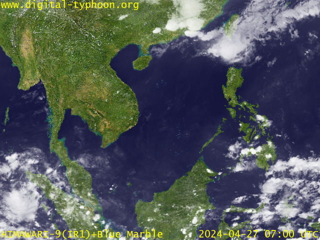
RECENT MTSAT-1R SATELLITE IMAGE:

> Image source: Digital-Typhoon.org (http://www.digital-typhoon.org )
__________________________________________________________________________________________
NOTES:

> Image source: Digital-Typhoon.
^ - JTWC commentary remarks (for Meteorologists) from their
latest warning.
latest warning.
* - Based on PAGASA's Philippine Storm Warning Signals,
# 4 being the highest. Red letters indicate new areas
being hoisted. For more explanations on these signals,
visit: http://www.typhoon2000.ph/signals.htm
** - Based on the Tropical Cyclone's Wave Height near
its center.
__________________________________________________________________________________________
>> To know the meteorological terminologies and acronyms
used on this update visit the ff:
http://typhoon2000.ph/tcterm.htm
http://www.nhc.noaa.gov/aboutgloss.shtml
http://www.srh.noaa.gov/oun/severewx/glossary.php
http://www.srh.weather.gov/fwd/glossarynation.html
http://www.nhc.noaa.gov/acronyms.shtml
__________________________________________________________________________________________
:: Typhoon2000.com (T2K) Mobile >> Powered by: Synermaxx
Receive the latest storm updates directly to your mobile phones! To know more:
Send T2K HELP to: 2800 (GLOBE & TM) | 216 (SMART & TNT) | 2288 (SUN)
Note: Globe & Smart charges P2.50 per message, while Sun at P2.00.
__________________________________________________________________________________________
For the complete details on STY SEPAT (EGAY)...go visit
our website @:
> http://www.typhoon2000.com
> http://www.maybagyo.com
# 4 being the highest. Red letters indicate new areas
being hoisted. For more explanations on these signals,
visit: http://www.typhoon2
** - Based on the Tropical Cyclone's Wave Height near
its center.
____________
>> To know the meteorological terminologies and acronyms
used on this update visit the ff:
http://typhoon2000.
http://www.nhc.
http://www.srh.
http://www.srh.
http://www.nhc.
____________
:: Typhoon2000.
Receive the latest storm updates directly to your mobile phones! To know more:
Send T2K HELP to: 2800 (GLOBE & TM) | 216 (SMART & TNT) | 2288 (SUN)
Note: Globe & Smart charges P2.50 per message, while Sun at P2.00.
For the complete details on STY SEPAT (EGAY)...go visit
our website @:
> http://www.typhoon2
> http://www.maybagyo
Change settings via the Web (Yahoo! ID required)
Change settings via email: Switch delivery to Daily Digest | Switch format to Traditional
Visit Your Group | Yahoo! Groups Terms of Use | Unsubscribe
SPONSORED LINKS
.
__,_._,___

4 comments:
According to my colleague, Sepat has just been downgraded from the fifth grade (Super Typhoon) to a fourth class (whatever that's called).
the term is "category 4" and Sepat is acting pretty much according to expectations. in one of the other posts there is a different map type that shows the predicted wind speeds with a lot less confusion.
either way man, we are going to get clobbered.
She's got a nice tight little eye. According to my colleague, that could mean trouble. Does it actually mean anything to have a tight little eye? I figure she's been out there for so long that she's gathering up something. BTW, why do all typhoons always seem to start in the same area in the Pacific?
Too bad she couldn't make it on a weekday.
Patrick, your colleague is right. the tight eye means that the storm is well organized and the power is therefore concentrated instead of being wasted as in the case of a loosely packed, lesser organized storm. a small eye also indicates a high power storm. like many things in life, it's about concentrating energy. this storm is very well organized and powerful.
they all start in the same basic area because the earth's weather system is basically an engine. and the engine runs in pretty much the same patterns unless something disrupts it, such as a volcanic eruption that puts lots of particulate matter into the atmosphere. all those storms spawn in warm water and they draw their power from warm water. if a typhoon has to pass over colder water it will lose some of its power. the most dangerous typhoons are the one that park offshore and just dump water on the land while maintaining their position over warm water which keeps them fueled. this partular storm has meandered along and built up plenty of power although thankfully it is weakening a bit.
just this evening i had a laugh with some of the local men who were sitting nearby drinking. "why couldn't it come on Monday or Tuesday?" i asked, which caused a lot of laughter, but probably more from the fact that a foreigner said it, lol.
there is still time left in the season for a few days off though!
Post a Comment