
Typhoon2000 STORM UPDATE #009
Name: TYPHOON USAGI [05W/0705]
Issued: 7:00 AM MANILA TIME (23:00 GMT) FRI 03 AUGUST 2007
Next Update: 7:00 PM (11:00 GMT) FRI 03 AUGUST
Source: JTWC TROPICAL CYCLONE WARNING #022
Next Update: 7:00 PM (11:00 GMT) FRI 03 AUGUST
Source: JTWC TROPICAL CYCLONE WARNING #022
_______________________________________________________________________
TYPHOON USAGI (05W) HAS WEAKENED CONSIDERABLY TO CATEGORY
ONE AFTER CROSSING EASTERN KYUSHU AND WESTERNMOST HONSHU
ONE AFTER CROSSING EASTERN KYUSHU AND WESTERNMOST HONSHU
LAST NIGHT...NOW OFF THE SEA OF JAPAN.
+ FORECAST OUTLOOK: USAGI will recurve towards the NE to ENE'ly as it starts transitioning into an Extratropical
Cyclone. 2-day forecast shows the system accelerating
anew across the Sea of Japan and becoming Extratropical
upon crossing Hokkaido, Japan.
+ EFFECTS: USAGI's core (eye + eyewall) is now weakening
and is now onshore along the Sea of Japan. Inner bands
continues to spread across Westernmost Honshu and Northern
Kyushu...while its outer bands remains across the Sea of
Japan, Southwestern Japan, Honshu and portions of South
Korea (east coast). Coastal Storm Surge flooding of 04 to
05 feet above normal tide levels...along with large and
dangerous battering waves can be expected near and to the
north of USAGI's projected path particularly the along the
coasts of Northern Kyushu, Westernmost Honshu. Flash floods
and mudslides are imminent along river banks, low-lying and
mountainous areas of the affected areas of SW Japan.
Precautionary measures must remain on high alert status
until the typhoon leaves.
+ TROPICAL CYCLONE WATCH: The European Centre for Medium-Range
Weather Forecasts (ECMWF) continues to forecast the formation
of a Tropical Cyclone around August 7 or 8. During the latest
run of the model forecast (8 PM Aug 02), it showed the system
forming over the Philippine Sea, just to the East of Luzon -
then heading WNW to NW in the direction of Taiwan as a Tropical
Storm between Aug 9 to 10. This potential storm might enhance
the Southwest Monsoon and bring moderate to heavy rains over
Luzon particularly the western portions. If this happens, it
may bring relief to the dry areas of Luzon particularly over
Angat Dam and other reservoirs. This scenario remains supported
by the Global Tropics Benefits/Hazard Assessment of NOAA. Watch
out for continued updates on this potential systems.
Meanwhile, the Tropical Disturbance (99W/LPA/1001 MB) over the
South China is now a fully developed Tropical Cyclone...watch
for the first email update on Tropical Depression 06W to be
issued tonight. For more info, go to:
http://www.typhoon2
Important Note: Please keep in mind that the above forecast
outlook, effects & current monsoon intensity, and tropical
cyclone watch changes every 06 to 12 hours!
____________
TIME/DATE: 5:00 AM MANILA TIME (21:00 GMT) 03 AUGUST
LOCATION OF EYE: LATITUDE 35.1º N...LONGITUDE 131.8º E
DISTANCE 1: 140 KM (75 NM) NNW OF HIROSHIMA, JAPAN
DISTANCE 2: 210 KM (113 NM) WNW OF OKAYAMA, JAPAN
DISTANCE 3: 250 KM (135 NM) ENE OF PUSAN, SOUTH KOREA
DISTANCE 4: 705 KM (380 NM) WSW OF NIIGATA, JAPAN
MAX SUSTAINED WINDS [1-MIN AVG]: 120 KM/HR (65 KTS)PEAK WIND GUSTS: 150 KM/HR (80 KTS)
SAFFIR-SIMPSON SCALE: CATEGORY ONE (1)
MINIMUM CENTRAL PRESSURE (est.): 974 MILLIBARS (hPa)
RECENT MOVEMENT: NORTH @ 24 KM/HR (13 KTS)
GENERAL DIRECTION: SEA OF JAPAN
STORM'S SIZE (IN DIAMETER): 590 KM (320 NM)/AVERAGE
MAX WAVE HEIGHT**: 20 FEET (6.0 METERS)
VIEW TRACKING MAP: 3 AM JST FRI AUGUST 03
TSR WIND PROBABILITIES: CURRENT TO 48 HRS LEAD
PHILIPPINE STORM SIGNALS*: N/A
12, 24 & 48 HR. FORECAST:
2 PM (06 GMT) 03 AUGUST: 37.2N 133.0E / 100-130 KPH / NE @ 33 KPH
2 AM (18 GMT) 04 AUGUST: 39.8N 136.1E / 85-100 KPH / NE @ 38 KPH
2 AM (18 GMT) 05 AUGUST: 44.0N 146.9E / 65-85 KPH / ENE @ 44 KPH
REMARKS: 2 AM (18 GMT) 03 AUGUST POSITION: 34.4N 131.4E.
^TYPHOON (TY) 05W (USAGI) MADE LANDFALL NEAR NOBEOKA, JAPAN
ON THE ISLAND OF KYUSHU AROUND 020830Z. THE STORM HAS WEAKENED
SIGNIFICANTLY OVER THE PAST 12 HOURS AND CURRENT INTENSITY IS
NOW AT 75 KNOTS. ANIMATED INFRARED SATELLITE IMAGERY AS WELL AS
A MICROWAVE SATELLITE IMAGE REFLECT THIS WEAKENING TREND. WATER
VAPOR IMAGERY AND TOTAL PRECIPITABLE WATER CONTINUE TO INDICATE
DRY AIR OVER THE WEST AND SOUTH SEMI-CIRCLES. THE MID-LEVEL DRY
AIR ENTRAINMENT AND LAND INTERACTION ARE THE PRIMARY FACTORS IN
WEAKENING THE SYSTEM AT THIS TIME...(more info)
>> USAGI {pronounced: usa-gi}, meaning: Lepus (rabbit).
Name contributed by: Japan.
____________
____________
RECENT TRACKING CHART:
________________________
RECENT MTSAT-1R SATELLITE IMAGE:
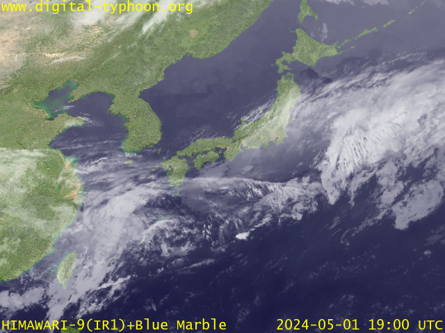
> Image source: Digital-Typhoon.org (Nat'l. Institute of Informatics) (http://www.digital-typhoon.org )
__________________________________________________________________________________________
NOTES:
> Image source: Digital-Typhoon.
^ - JTWC commentary remarks (for Meteorologists) from their
latest warning.
latest warning.
* - Based on PAGASA's Philippine Storm Warning Signals,
# 4 being the highest. Red letters indicate new areas
being hoisted. For more explanations on these signals,
visit: http://www.typhoon2000.ph/signals.htm
** - Based on the Tropical Cyclone's Wave Height near
its center.
__________________________________________________________________________________________
>> To know the meteorological terminologies and acronyms
used on this update visit the ff:
http://typhoon2000.ph/tcterm.htm
http://www.nhc.noaa.gov/aboutgloss.shtml
http://www.srh.noaa.gov/oun/severewx/glossary.php
http://www.srh.weather.gov/fwd/glossarynation.html
http://www.nhc.noaa.gov/acronyms.shtml
__________________________________________________________________________________________
:: Typhoon2000.com (T2K) Mobile >> Powered by: Synermaxx
Receive the latest storm updates directly to your mobile phones! To know more:
Send T2K HELP to: 2800 (GLOBE & TM) | 216 (SMART & TNT) | 2288 (SUN)
Note: Globe & Smart charges P2.50 per message, while Sun at P2.00.
__________________________________________________________________________________________
For the complete details on TY USAGI (05W)...go visit
our website @:
> http://www.typhoon2000.com
> http://www.maybagyo.com
# 4 being the highest. Red letters indicate new areas
being hoisted. For more explanations on these signals,
visit: http://www.typhoon2
** - Based on the Tropical Cyclone's Wave Height near
its center.
____________
>> To know the meteorological terminologies and acronyms
used on this update visit the ff:
http://typhoon2000.
http://www.nhc.
http://www.srh.
http://www.srh.
http://www.nhc.
____________
:: Typhoon2000.
Receive the latest storm updates directly to your mobile phones! To know more:
Send T2K HELP to: 2800 (GLOBE & TM) | 216 (SMART & TNT) | 2288 (SUN)
Note: Globe & Smart charges P2.50 per message, while Sun at P2.00.
For the complete details on TY USAGI (05W)...go visit
our website @:
> http://www.typhoon2
> http://www.maybagyo
Change settings via the Web (Yahoo! ID required)
Change settings via email: Switch delivery to Daily Digest | Switch format to Traditional
Visit Your Group | Yahoo! Groups Terms of Use | Unsubscribe
SPONSORED LINKS
.
__,_._,___

No comments:
Post a Comment