Typhoon2000 STORM UPDATE #15 **FINAL**
Name: TROPICAL STORM KAEMI [GLENDA/06W/0605]
Issued: 7:00 AM MANILA TIME (23:00 GMT) WED 26 JULY 2006
Source: JTWC TROPICAL CYCLONE WARNING #031 (FINAL)
_______________________________________________________________________
Source: JTWC TROPICAL CYCLONE WARNING #031 (FINAL)
____________
TROPICAL STORM KAEMI (GLENDA) HAS MADE ITS SECOND
LANDFALL OVER FUJIAN PROVINCE LAST NIGHT AND IS NOW
LANDFALL OVER FUJIAN PROVINCE LAST NIGHT AND IS NOW
RAPIDLY DISSIPATING OVERLAND.
...THIS IS THE FINAL UPDATE ON THIS SYSTEM.
...THIS IS THE FINAL UPDATE ON THIS SYSTEM.
+ FORECAST OUTLOOK: The storm is forecast to continue
to rapidly dissipate today as it traverses the moun-
tainous terrain of Southeastern China Mainland.
+ EFFECTS: KAEMI's dissipating bands will continue to
affect Hong Kong, SW & SE China and portions of South
China Sea. Moderate to heavy rains with gale-force winds
of up to 85 km/hr may be expected within the storm's
inner spiral bands with decreasing wind speeds along
its outer bands.
+ CURRENT MONSOON INTENSITY: Strong Southwest (SW) Monsoon
still affecting Luzon becoming more intense & rainy along
the western sections (including Metro Manila, Dagupan City
& Subic Bay). Cloudy weather conditions with light to mo-
derate to sometimes heavy rainfall & very rough seas can
be expected over the affected areas today. Southwesterly
winds of 30 to 60 km/hr with higher gusts may be expected
along the affected areas.
+ TROPICAL CYCLONE WATCH: The new Tropical Disturbance
(LPA/96W/1008 mb) over the Philippine Sea or near the
Island of Palau remains disorganized. The disturbance
was located about 1,040 km East of Surigao City (9.4N
135.0E)..moving Westward slowly. Watch for more
updates on this intensifying disturbance later..please
stay tuned.
outlook, effects, current monsoon intensity, and tropical
cyclone watch changes every 06 to 12 hours!
_______________________________________________________________________
TIME/DATE: 11:00 PM MANILA TIME (15:00 GMT) 26 JULY
LOCATION OF CENTER: LATITUDE 24.9º N...LONGITUDE 117.0º E
DISTANCE 1: 120 KM (65 NM) WNW OF XIAMEN, CHINA
DISTANCE 2: 170 KM (92 NM) NNE OF SHANTOU, CHINA
DISTANCE 3: 415 KM (225 NM) NE OF HONG KONG, CHINA
DISTANCE 4: 710 KM (383 NM) NW OF BASCO, BATANES, PH
MAX SUSTAINED WINDS [1-MIN AVG]: 85 KM/HR (45 KTS)
PEAK WIND GUSTS: 100 KM/HR (55 KTS)
MINIMUM CENTRAL PRESSURE (est.): 991 MILLIBARS (hPa)
MAX WAVE HEIGHT**: .. FEET (... METERS)/OVERLAND
SAFFIR-SIMPSON SCALE: N/A
RECENT MOVEMENT: NW @ 22 KM/HR (12 KTS)
GENERAL DIRECTION: CHINA MAINLAND
STORM'S SIZE (IN DIAMETER): 650 KM (350 NM)/AVERAGE
VIEW T2K TRACKING MAP: 11 PM TUE JULY 25
TSR WIND PROBABILITIES: CURRENT TO 12 HRS LEAD
PHILIPPINE STORM SIGNALS*: N/A
09-21 HR. FORECAST:
> 8 AM (00 GMT) 26 JULY: 25.8N 115.7E / 55-75 KPH
REMARKS: 8 PM (12 GMT) 25 JULY POSITION: 24.6N 117.5E.
^THE MOUNTAINOUS TERRAIN OF TAIWAN HAS WEAKENED TY
KAEMI SIGNIFICANTLY. MODERATE VERTICAL WIND SHEAR
AND LAND EFFECTS WILL INHIBIT STORM INTENSIFICATION.
RAPID WEAKENING IS EXPECTED AFTER THE STORM MOVES
ASHORE NEAR XIAMEN, CHINA...(more info)
>> KAEMI {pronounced: gae~mi}, meaning: An ant. A very
small insect that lives in highly organized groups.
It often appears in Korean fairy tales as a symbol
of diligence. Name contributed by: Republic of Korea.
_________________________________________________________________________________
_________________________________________________________________________________
____________
LATEST T2K TRACKING CHART:

________________________
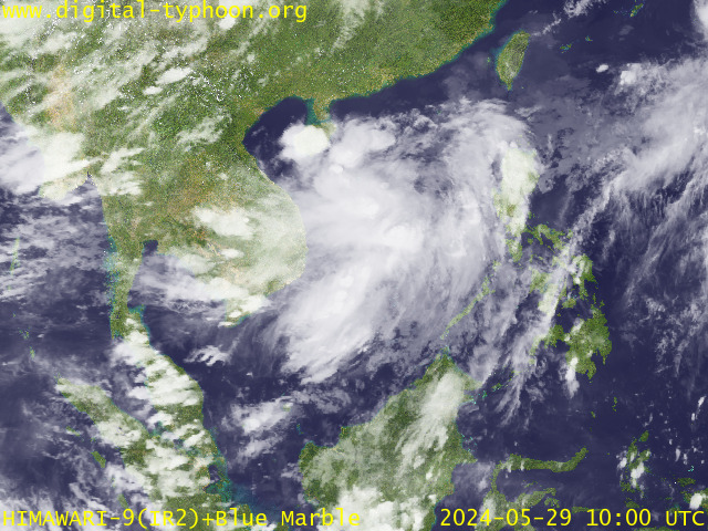
RECENT MTSAT-1R SATELLITE IMAGE:

> Image source: Digital-Typhoon.
NOTES:
^ - JTWC commentary remarks (for Meteorologists) from their
latest warning.
latest warning.
* - Based on PAGASA's Philippine Storm Warning Signals,
# 4 being the highest. Red letters indicate new areas
being hoisted. For more explanations on these signals,
visit: http://www.typhoon2000.ph/signals.htm
** - Based on the Tropical Cyclone's Sea Wave Height near
its center.
__________________________________________________________________________________________
>> To know the meteorological terminologies and acronyms
used on this update visit the ff:
http://typhoon2000.ph/tcterm.htm
http://www.nhc.noaa.gov/aboutgloss.shtml
http://www.srh........noaa.gov/oun/severewx/glossary.php
http://www.srh.weather.gov/fwd/glossarynation.html
http://www.nhc.noaa.gov/acronyms.shtml
__________________________________________________________________________________________
:: Typhoon2000.com (T2K) Mobile >> Powered by: Synermaxx
Receive the latest storm updates directly to your mobile phones! To know more:
Send T2K HELP to: 2800 (GLOBE & TM) | 216 (SMART & TNT) | 2288 (SUN)
__________________________________________________________________________________________
For the complete details on the TS KAEMI (GLENDA)...go visit
our website @:
> http://www.typhoon2000.com
> http://www.maybagyo.com
# 4 being the highest. Red letters indicate new areas
being hoisted. For more explanations on these signals,
visit: http://www.typhoon2
** - Based on the Tropical Cyclone's Sea Wave Height near
its center.
____________
>> To know the meteorological terminologies and acronyms
used on this update visit the ff:
http://typhoon2000.
http://www.nhc.
http://www.srh.
http://www.srh.
http://www.nhc.
____________
:: Typhoon2000.
Receive the latest storm updates directly to your mobile phones! To know more:
Send T2K HELP to: 2800 (GLOBE & TM) | 216 (SMART & TNT) | 2288 (SUN)
____________
For the complete details on the TS KAEMI (GLENDA)...go visit
our website @:
> http://www.typhoon2
> http://www.maybagyo
You are receiving Individual Emails Change Delivery Settings
Visit Your Group | Yahoo! Groups Terms of Use | Unsubscribe
New Message Search
Find the message you want faster. Visit your group to try out the improved message search.
.
__,_._,___
No comments:
Post a Comment