| My Groups | typhoon2000asiapac_stormlist Main Page | |

Typhoon2000 STORM UPDATE #10
Name: TYPHOON CHANCHU [CALOY/02W/0601]
Issued: 7:00 PM MANILA TIME (11:00 GMT) SAT 13 MAY 2006
Next Update: 7:00 AM (23:00 GMT) SUN 14 MAY 2006
Source: JTWC TROPICAL CYCLONE WARNING #019
_______________________________________________________________________
Next Update: 7:00 AM (23:00 GMT) SUN 14 MAY 2006
Source: JTWC TROPICAL CYCLONE WARNING #019
_______________________________________________________________________
TYPHOON CHANCHU (CALOY) BEGINS RE-ORGANIZING OVER THE SOUTH-
CHINA SEA AS ITS CIRCULATION EXPANDS...OUTER BANDS STILL COVERING
MUCH OF THE PHILIPPINES.
+ FORECAST OUTLOOK: The core of CHANCHU is expected to continue
moving WNW across the South China Sea & away from the Philippines.
After 36 hours, CHANCHU shall turn sharply Northward. The 5-day
Advance Forecast still shows the typhoon intensifying into a
220-kph howler before striking Hong Kong, China around May 17.
+ EFFECTS: CHANCHU's core (eyewall/inner rainbands) is now over the
South China Sea but still slightly affecting Lubang Island, while
its outer rainbands has expanded and is now covering much of the
Philippine Islands. These rainbands will continue to bring moderate
to heavy rainfall with moderate to strong winds, and could produce
life-threatening flash floods and mudslides along river banks,
low-lying areas and mountain slopes over the affected areas. Resi-
dents residing along the coastal beachfront areas of Palawan, Wes-
tern Luzon & Western Visayas are advised to seek higher grounds due
to possible high waves from the sea. Coastal Storm Surge flooding
of up to 3 to 5 feet can be expected along the path of CHANCHU ad-
vising all sea vessels to remain at port.
+ CURRENT MONSOON INTENSITY: This storm is currntly enhancing the
Southwest Monsoon bringing moderate to heavy rains along Western
sections of Visayas and Mindanao. These rains may produce life-
threatening flash floods and mudslides along river banks, low-
lying areas and mountain slopes of the affected areas.
Important Note: Please keep in mind that the above forecast outlook,
effects & current monsoon intensity changes every 06 to 12 hours!
_______________________________________________________________________
TIME/DATE: 5:00 PM MANILA TIME (09:00 GMT) 13 MAY
LOCATION OF CENTER: LATITUDE 13.9º N...LONGITUDE 119.0º E
DISTANCE 1: 225 KM (121 NM) WSW OF METRO MANILA, PH
TIME/DATE: 5:00 PM MANILA TIME (09:00 GMT) 13 MAY
LOCATION OF CENTER: LATITUDE 13.9º N...LONGITUDE 119.0º E
DISTANCE 1: 225 KM (121 NM) WSW OF METRO MANILA, PH
DISTANCE 2: 170 KM (92 NM) SW OF SUBIC BAY, PH
DISTANCE 3: 135 KM (73 NM) WNW OF LUBANG ISLAND, PH
MAX SUSTAINED WINDS [1-MIN AVG]: 140 KM/HR (75 KTS)
PEAK WIND GUSTS: 165 KM/HR (90 KTS)
MINIMUM CENTRAL PRESSURE (est.): 967 MILLIBARS (hPa)
MAX WAVE HEIGHT**: 32 FEET (9.7 METERS)
SAFFIR-SIMPSON SCALE: CATEGORY 1
RECENT MOVEMENT: WNW @ 20 KM/HR (11 KTS)
GENERAL DIRECTION: SOUTH CHINA SEA
STORM'S SIZE (IN DIAMETER): 925 KM (500 NM)/VERY LARGE
VIEW T2K TRACKING MAP: 5 PM SAT MAY 13
TSR WIND PROBABILITIES: CURRENT TO 120 HRS LEAD
PHILIPPINE STORM SIGNALS*:
#02 - MINDORO, LUBANG ISLAND, BATANGAS, CAVITE, BATAAN, CALAMIAN
GROUP, ROMBLON & MARINDUQUE.
#01 - METRO MANILA, LAGUNA, RIZAL, BULACAN, PAMPANGA, TARLAC,
ZAMBALES AND PALAWAN & CUYO ISLAND.
09-21 HR. FORECAST:
> 2 AM (18 GMT) 14 MAY: 14.3N 117.7E / 160-195 KPH
> 2 PM (06 GMT) 14 MAY: 14.7N 116.2E / 175-215 KPH
REMARKS: 2 PM (06 GMT) 13 MAY POSITION: 13.8N 119.4E.
^ WHILE THE TRACK OF TY CHANCHU BECAME ERRATIC WHILE
CROSSING THE ISLAND OF MINDORO, THE SYSTEM WILL RESUME
A WEST-NORTHWESTWARD TRACK ALONG THE SOUTHERN PERIP-
HERY OF A MID-LEVEL STEERING RIDGE CENTERED SOUTH OF
HONG KONG. A SERIES OF MIDLATITUDE TROUGHS WILL WEAKEN
THE STEERING RIDGE AND CAUSE TY 02W TO TURN POLEWARD
AFTER 48 HOURS. (more info)
>> CHANCHU {pronounced: chan~chu}, meaning: Pearl, a smooth,
rounded lustrous deposit formed in the shells of certain
oysters and is often used for jewelry. Many Macau souvenirs
are made of it. Name contributed by: Macau, China
_______________________________________________________________________
>> CHANCHU {pronounced: chan~chu}, meaning: Pearl, a smooth,
rounded lustrous deposit formed in the shells of certain
oysters and is often used for jewelry. Many Macau souvenirs
are made of it. Name contributed by: Macau, China
_______________________________________________________________________
PAGASA CURRENT POSITION, MOVEMENT AND INTENSITY (10-min. ave.):
> 4 PM (08 GMT) 13 MAY: 13.9N 118.9E / WNW @ 15 KPH / 110 kph
:: For the complete PAGASA bulletin, kindly visit their website at:
:: For the complete PAGASA bulletin, kindly visit their website at:
http://www.pagasa.dost.gov.ph/wb/tcupdate.shtml
_________________________________________________________________________________
_________________________________________________________________________________
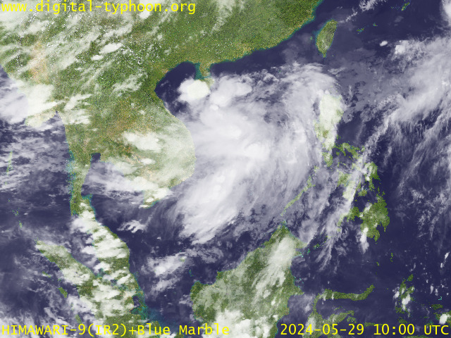
RECENT MTSAT-1R SATELLITE IMAGE:

> Image source: Digital-Typhoon.org (Nat'l. Institute of Informatics) (http://www.digital-typhoon.org)
__________________________________________________________________________________________
LATEST T2K TRACKING CHART:

_______________________________________________________________________________________
NOTES:

> Image source: Digital-Typhoon.org (Nat'l. Institute of Informatics) (http://www.digital-typhoon.org)
__________________________________________________________________________________________
LATEST T2K TRACKING CHART:

_______________________________________________________________________________________
NOTES:
^ - JTWC commentary remarks (for Meteorologists) from their latest warning.
* - Based on PAGASA's Philippine Storm Warning Signals, # 4 being the
highest. Red letters indicate new areas being hoisted. For more
explanations on these signals, visit: http://www.typhoon2000.ph/signals.htm
** - Based on the Tropical Cyclone's Sea Wave Height near its center.
__________________________________________________________________________________________
>> To know the meteorological terminologies and acronyms used on
this update visit the ff:
http://typhoon2000.ph/tcterm.htm
http://www.nhc.noaa.gov/aboutgloss.shtml
http://www.srhnoaa.gov/oun/severewx/glossary.php
http://www.srh.weather.gov/fwd/glossarynation.html
http://www.nhc.noaa.gov/acronyms.shtml
__________________________________________________________________________________________
T2K Mobile: receive the latest storm updates directly to your mobile phones! To know more,
Send T2K HELP to: 2800 (GLOBE & TM) | 386 (SMART & TNT) | 2288 (SUN)
Powered by: Synermaxx
__________________________________________________________________________________________
For the complete details on the TY CHANCHU (CALOY)...go visit our website @:
> http://www.typhoon2000.com
> http://www.maybagyo.com
:: Kindly view our site's disclaimer at: http://www.typhoon2000.ph/disclaimer.htm
YAHOO! GROUPS LINKS
- Visit your group "typhoon2000asiapac_stormlist" on the web.
- To unsubscribe from this group, send an email to:
typhoon2000asiapac_stormlist-unsubscribe@yahoogroups.com
- Your use of Yahoo! Groups is subject to the Yahoo! Terms of Service.
No comments:
Post a Comment