
for Friday, 11 October 2013 [3:39 PM PhT]
WEATHER.COM.PH TROPICAL CYCLONE UPDATES
TYPHOON NARI (SANTI) UPDATE NUMBER 008
Issued at: 1:45 PM PhT (05:45 GMT) Friday 11 October 2013
Typhoon NARI (SANTI) has slowed down and gained more strength as it moves west over the Central Philippine Sea...endangers further Central and Northern Luzon. Its western outer rainbands are spreading across the whole of Luzon including Metro Manila and Bicol Region...likely to make landfall over Aurora late this evening.
Residents and visitors along Luzon including Metro Manila and Bicol Region should closely monitor the development of Nari (Santi).
Do not use this for life or death decisions. This update is intended for additional information purposes only. Kindly refer to your national weather agency for official warnings, advisories or bulletins.
CURRENT STORM ANALYSIS
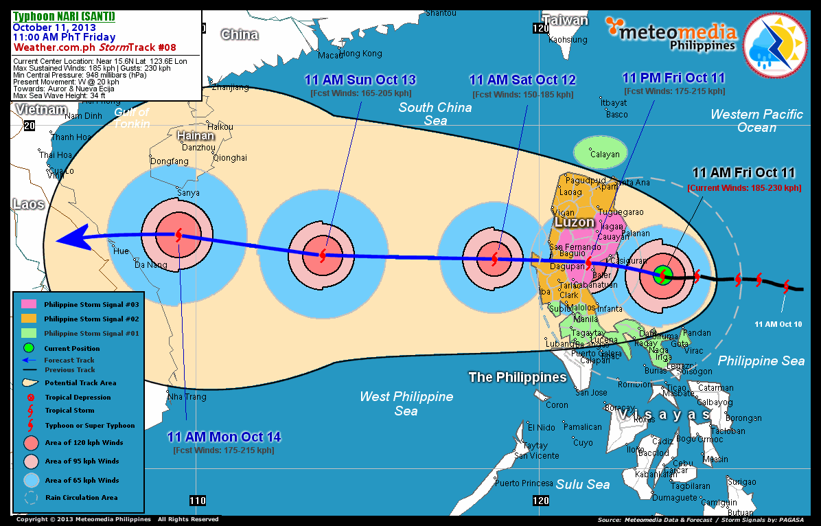
As of 11:00 am today, the eye of TY Nari (Santi) was located over the western part of the Central Philippine Sea...about 180 km north-northwest of Pandan, Catanduanes or 175 km east-southeast of Casiguran, Aurora...currently moving west with a decreased forward speed of 20 km/hr towards Aurora and Nueva Ecija Provinces.
Maximum Sustained Winds (1-min. avg) have rapidly increased to 185 km/hr near the center with higher gusts. Typhoon Force Winds (118 km/hr or more) extend outward up to 75 kilometers from the center...and Tropical Storm Force Winds (63-117 km/hr) extend outward up to 165 kilometers. Nari (Santi) remains a large-sized tropical cyclone with a diameter of 685 kilometers across. The 24-hour rainfall accumulation near the center of Nari (Santi) is estimated to be extreme (400 mm).
2-DAY FORECAST OUTLOOK*
TY Nari (Santi) is expected to move west-northwest to west with an increase in forward speed during the next 24 hours...slowing slightly through 48 hours. On the forecast track, the core of Nari (Santi) will be passing well to the north of Bicol Region this afternoon...and will be making landfall over Aurora somewhere north and very close to the town of Baler this evening. Nari (Santi) will then traverse the provinces of Nueva Ecija and Pangasinan late tonight through Saturday early morning before moving out into the West Philippine Sea. Throughout Saturday, the typhoon will be cruising along the Scarborough (Panatag) Shoal in the West Philippine Sea, exiting the Philippine Area of Responsibility (PAR) late Saturday night.
TY Nari (Santi) is expected to weaken during the next 12 to 24 hours as it interacts with the mountain range of Sierra Madre. Advance Intensity Forecast (AIF) shows its 1-minute maximum sustained winds decreasing to 175 km/hr after making landfall over Aurora Province tonight and decrease further to 150 km/hr by tomorrow morning.
The following is the summary of the 2-day forecast outlook and an extended 3-day forecast on this system:
 SATURDAY MORNING: Weakens to a Category 1 TY while emerging into the West Philippine Sea...about 170 km west of Dagupan City, Pangasinan [11AM OCT 12: 16.1N 118.7E @ 150kph].
SUNDAY MORNING: Cruising over the West Philippine Sea after exiting PAR...regains Category 2 strength...about 660 km west of Cape Bolinao, Pangasinan [11AM OCT 13: 16.2N 113.7E @ 165kph].
MONDAY MORNING: Still heading westward...intensifies more as it approaches the coast of Central Vietnam...about 155 km south of Sanya, Hainan Island [11AM OCT 14: 16.8N 109.5E @ 175kph].
*Please be reminded that the Forecast Outlook changes every 6 hours, and the Day 2 and 3 Forecast Track has an average error of 100 and 250 km respectively...while the wind speed forecast error, averages 35 kph per day. Therefore, a turn to the left or right of its future track and changes in its wind speed must be anticipated from time to time.
EFFECTS & HAZARDS SUMMARY
Below is the summary of the storm's parts and its hazards affecting specific areas. You can also view this image link for you to understand the parts.
CLOUD-FILLED EYE - Western Part of Central Philippine Sea. Possible calm and lull conditions (with <20 kph winds) will be expected inside the eye (click here to know more about the EYE). EYEWALL - where Typhoon Conditions with Typhoon Force Winds (>118 kph) will be expected within this wall. Affected Areas: Western Part of Central Philippine Sea.. (click here to know more about the Eyewall). INNER RAINBANDS - where Tropical Storm Conditions with Tropical Storm Force Winds (63-100 kph) will be expected. Affected Areas: Coastal areas of Partido District in Camarines Sur and Camarines Norte, Catanduanes, Eastern sections of Northern and Central Luzon, and the Western Part of Central Philippine Sea. OUTER RAINBANDS - where Tropical Depression Conditions with light, moderate to strong winds (30-62 kph) will be expected. Affected Areas: Western Part of Central Philippine Sea and the whole of Luzon including Metro Manila, Rest of Bicol Region, Mindoro, Masbate, and Panay. (click here to know more about Rainbands). 24HR TOTAL RAINFALL ACCUMULATION - from 5 up to 100 mm (slight to heavy rainfall) can be expected along areas affected by the outer & inner rainbands (see above)...with isolated amounts of 101 to 400 mm (heavy to extreme) along areas to the west, south and near the center of Nari (Santi). COASTAL STORM SURGE FLOODING - possible 9-12 ft (2.7-3.9 m) above normal tide levels...accompanied by large and dangerous battering waves can be expected along the coastal, inland lakes and beach front areas of Eastern Luzon today. Extensive damage is likely on this type of storm surge. Danger from Rip Currents or Rip Tides can be expected along the rest of the beach-front areas of Luzon and Northern Visayas (click here to know more about Storm Surge).
Important Note: Please keep in mind that the above forecast outlook, effects and hazards summary changes every 6 to 12 hrs!
CURRENT TECHNICAL INFORMATION
Time/Date: 11:00 AM PhT Fri Oct 11, 2013
Class/Name: TY Nari (Santi)
Location of Eye: Near 15.6º N Lat 123.6º E Lon
Distance 1: 180 km NNW of Pandan, Catanduanes
Distance 2: 230 km NNW of Virac, Catanduanes
Distance 3: 185 km NNE of Daet, CamNorte
Distance 4: 225 km NNE of Metro Naga
Distance 5: 175 km ESE of Casiguran, Aurora
Distance 6: 190 km ENE of Polillo Island
Distance 7: 215 km E of Baler, Aurora
Distance 8: 305 km ENE of Metro Manila
MaxWinds (1-min avg): 185 kph near the center
Peak Wind Gusts: 230 kph
Saffir-Simpson Hurricane Scale: Category 3
Present Movement: West @ 20 kph
Towards: Aurora & Nueva Ecija Provinces
CPA [ETA] to Aurora: Tonight [between 9PM-11PM PhT]
24hr Rainfall Accum (Near the Center): Extreme [400 mm]
Minimum Central Pressure: 948 millibars (hPa)
Size (in Diameter): 685 km [Large]
Max Sea Wave Height (near center): 34 feet
Possible Storm Surge Height: 9-12 ft (2.7-3.9 m)
T2K/WP StormTracks (for Public): GIF | Google Map (Flash)
CURRENT TRACKING MAP:
 _____________________________________________________________________________
__________________________________________________________________________________________________
CURRENT NOAA/MTSAT-2 INFRARED (IR) SATELLITE IMAGE:

__________________________________________________________________________________________________
>> To know the meteorological terminologies and acronyms used on this update visit the ff:
http://typhoon2000.ph/tcterm.htm
http://www.nhc.noaa.gov/aboutgloss.shtml
http://www.nhc.noaa.gov/acronyms.shtml
__________________________________________________________________________________________
For the complete details on TY NARI (SANTI)...go visit our website @:
> http://www.typhoon2000.com
> http://www.maybagyo.com
<<<Typhoon2000.com Mobile >>>
Get the latest SMS Storm Alerts!
For more details: Text T2K TYPHOON to
2800 (Globe/TM) | Offline (Smart/TNT) | 2288 (Sun)
*Only P2.50 (Smart/Globe) / P2.00 (Sun) per msg received.
Click here on how to use this service (in PDF file)
Powered by: Synermaxx Corporation
Copyright © 2013 Typhoon2000.com All Rights Reserved
| Reply via web post | Reply to sender | Reply to group | Start a New Topic | Messages in this topic (1) |

No comments:
Post a Comment