
for Thursday, 10 October 2013 [8:59 PM PhT]
WEATHER.COM.PH TROPICAL CYCLONE UPDATES
TYPHOON NARI (SANTI) UPDATE NUMBER 006
Issued at: 7:00 PM PhT (11:00 GMT) Thursday 10 October 2013
Tropical Storm NARI (SANTI) has strengthened into a Typhoon...Outermost western rainbands continues to spread across the Bicol Region and Eastern Luzon (from Isabela down to Southern Quezon). Threat to Central and Northern Luzon increases.
Residents and visitors along Luzon including Bicol Region and Batanes Group of Islands should closely monitor the development of Nari (Santi).
Do not use this for life or death decisions. This update is intended for additional information purposes only. Kindly refer to your national weather agency for official warnings, advisories or bulletins.
CURRENT STORM ANALYSIS
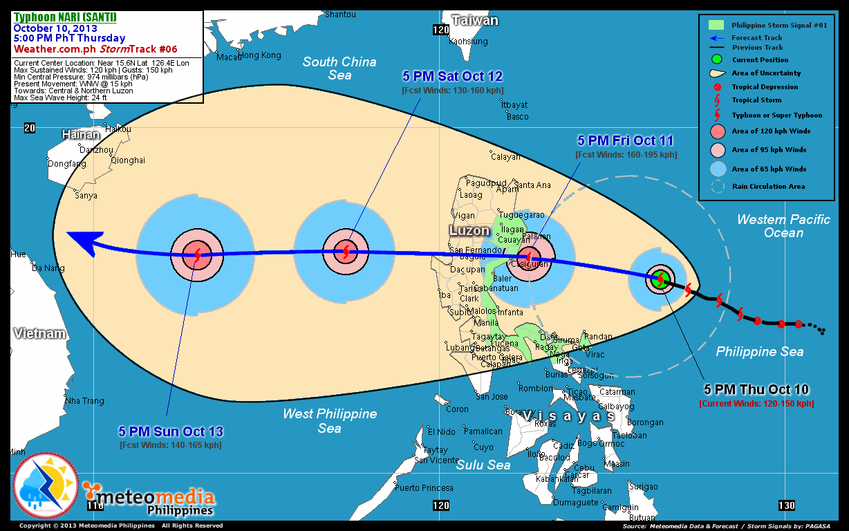
As of 5:00 pm today, the center of TY Nari (Santi) was located over the Central Philippine Sea...about 290 km northeast of Pandan, Catanduanes or 465 km east-southeast of Casiguran, Aurora...currently moving west-northwest with a forward speed of 15 km/hr towards Aurora and Quirino Provinces.
Maximum Sustained Winds (1-min. avg) have increased to 120 km/hr near the center with higher gusts. Typhoon Force Winds (118 km/hr or more) extend outward up to 45 kilometers from the center...and Tropical Storm Force Winds (63-117 km/hr) extend outward up to 100 kilometers. Nari (Santi) is an average-sized tropical cyclone with a diameter of 555 kilometers across. The 24-hour rainfall accumulation near the center of Nari (Santi) is estimated to be extreme (310 mm).
2-DAY FORECAST OUTLOOK*
TY Nari (Santi) is expected to move west-northwest to west during the next 24 through 48 hours. On the forecast track, the core of Nari (Santi) will be passing well to the north of Bicol Region..and will be just off the coast of Northern Aurora on Friday afternoon. By the evening of Friday, Nari (Santi) will make landfall over Northern Aurora somewhere over or very close to the town of Casiguran...and will traverse the provinces of Quirino, Nueva Ecija, Southern Benguet and Southern La Union on Friday night through Saturday early morning before moving into Lingayen Gulf.
TY Nari (Santi) will continue to rapidly intensify during the next 24 hours...becoming a Category 2 Typhoon (TY) on Friday afternoon. Advance Intensity Forecast (AIF) shows its 1-minute maximum sustained winds reaching 160 km/hr before it makes landfall over Aurora Province.
The following is the summary of the 2-day forecast outlook and an extended 3-day forecast on this system:
 FRIDAY AFTERNOON: Becomes Category 2 Typhoon as it moves west closer to Northern Aurora...about 55 km east of Casiguran, Aurora [5PM OCT 11: 16.2N 122.6E @ 160kph].
SATURDAY AFTERNOON: Weakens after crossing the Southern Part of Northern Luzon...emerges over the Lingayen Gulf...about 320 km west-northwest of Dagupan City, Pangasinan [5PM OCT 12: 16.4N 117.3E @ 130kph].
SUNDAY AFTERNOON: Regaining intensity as it moves across the West Philippine Sea...exits the Philippine Area of Responsibility (PAR)...about 780 km west of Dagupan City, Pangasinan [5PM OCT 13: 16.3N 113.0E @ 140kph].
*Please be reminded that the Forecast Outlook changes every 6 hours, and the Day 2 and 3 Forecast Track has an average error of 100 and 250 km respectively...while the wind speed forecast error, averages 35 kph per day. Therefore, a turn to the left or right of its future track and changes in its wind speed must be anticipated from time to time.
EFFECTS & HAZARDS SUMMARY
Below is the summary of the storm's parts and its hazards affecting specific areas. You can also view this image link for you to understand the parts.
CLOUD-FILLED EYE - Western Part of Central Philippine Sea. Possible calm and lull conditions (with <20 kph winds) will be expected inside the eye (click here to know more about the EYE). EYEWALL - where Typhoon Conditions with Typhoon Force Winds (>118 kph) will be expected within this wall. Affected Areas: Western Part of Central Philippine Sea.. (click here to know more about the Eyewall). INNER RAINBANDS - where Tropical Storm Conditions with Tropical Storm Force Winds (63-100 kph) will be expected. Affected Areas: Western Part of Central Philippine Sea. OUTER RAINBANDS - where Tropical Depression Conditions with light, moderate to strong winds (30-62 kph) will be expected. Affected Areas: Western Part of Central Philippine Sea and the eastern coastal areas of Eastern Luzon (from Eastern Cagayan down to Southern Quezon) & Bicol Region. (click here to know more about Rainbands). 24HR TOTAL RAINFALL ACCUMULATION - from 5 up to 100 mm (slight to heavy rainfall) can be expected along areas affected by the outer & inner rainbands (see above)...with isolated amounts of 101 to 310 mm (heavy to extreme) along areas to the west, south and near the center of Nari (Santi). COASTAL STORM SURGE FLOODING - possible 4-5 ft (1.2-1.7 m) above normal tide levels...accompanied by large and dangerous battering waves can be expected along the coastal, inland lakes and beach front areas of Eastern Luzon & Bicol Region tonight and tomorrow. Minimal damage is likely on this type of storm surge. Danger from Rip Currents or Rip Tides can be expected along the rest of the beach-front areas of Luzon and Northern Visayas (click here to know more about Storm Surge).
Important Note: Please keep in mind that the above forecast outlook, effects and hazards summary changes every 6 to 12 hrs!
CURRENT TECHNICAL INFORMATION
Time/Date: 5:00 PM PhT Thu Oct 10, 2013
Class/Name: TY Nari (Santi)
Location of Center: Near 15.6º N Lat 126.4º E Lon
Distance 1: 290 km NE of Pandan, Catanduanes
Distance 2: 325 km NE of Virac, Catanduanes
Distance 3: 410 km NE of Metro Naga
Distance 4: 410 km ENE of Daet, CamNorte
Distance 5: 465 km ESE of Casiguran, Aurora
Distance 6: 490 km ENE of Polillo Island
Distance 7: 525 km E of Baler, Aurora
Distance 8: 595 km ENE of Metro Manila
MaxWinds (1-min avg): 120 kph near the center
Peak Wind Gusts: 150 kph
Saffir-Simpson Hurricane Scale: Category 1
Present Movement: WNW @ 15 kph
Towards: Aurora & Quirino Provinces
CPA [ETA] to Aurora: Friday Evening [between 6PM-8PM PhT]
24hr Rainfall Accum (Near the Center): Extreme [310 mm]
Minimum Central Pressure: 974 millibars (hPa)
Size (in Diameter): 555 km [Average]
Max Sea Wave Height (near center): 24 feet
T2K/WP StormTracks (for Public): GIF | Google Map (Flash)
CURRENT TRACKING MAP:
 _____________________________________________________________________________
__________________________________________________________________________________________________
CURRENT NOAA/MTSAT-2 INFRARED (IR) SATELLITE IMAGE:

__________________________________________________________________________________________________
>> To know the meteorological terminologies and acronyms used on this update visit the ff:
http://typhoon2000.ph/tcterm.htm
http://www.nhc.noaa.gov/aboutgloss.shtml
http://www.nhc.noaa.gov/acronyms.shtml
__________________________________________________________________________________________
For the complete details on TY NARI (SANTI)...go visit our website @:
> http://www.typhoon2000.com
> http://www.maybagyo.com
<<<Typhoon2000.com Mobile >>>
Get the latest SMS Storm Alerts!
For more details: Text T2K TYPHOON to
2800 (Globe/TM) | Offline (Smart/TNT) | 2288 (Sun)
*Only P2.50 (Smart/Globe) / P2.00 (Sun) per msg received.
Click here on how to use this service (in PDF file)
Powered by: Synermaxx Corporation
Copyright © 2013 Typhoon2000.com All Rights Reserved
| Reply via web post | Reply to sender | Reply to group | Start a New Topic | Messages in this topic (1) |

No comments:
Post a Comment