
for Wednesday, 09 October 2013 [1:24 PM PhT]
WEATHER.COM.PH TROPICAL CYCLONE UPDATES
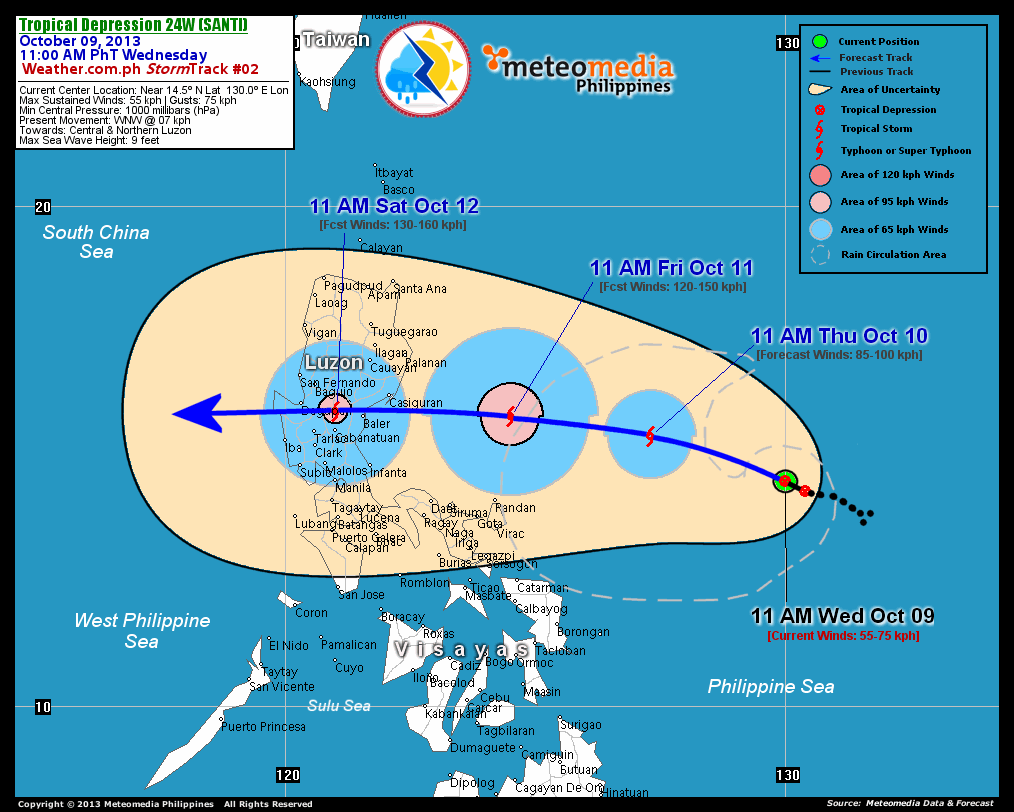
TROPICAL DEPRESSION 24W (SANTI) UPDATE NUMBER 002
Issued at: 12:30 PM PhT (04:30 GMT) Wednesday 09 October 2013
Tropical Depression 24W (SANTI) has slightly gained strength while slowing down over the central part of the Philippine Sea. Threat to Luzon continues...with a Projected Landfall Area over the province of Aurora on Saturday morning. Its outermost, developing rainbands are now spreading along the eastern shorelines of Catanduanes and Northern Samar.
Residents and visitors along Luzon including Bicol Region and Batanes Group of Islands should closely monitor the development of 24W (Santi).
Do not use this for life or death decisions. This update is intended for additional information purposes only. Kindly refer to your national weather agency for official warnings, advisories or bulletins.
CURRENT STORM ANALYSIS
As of 11:00 am today, the developing center of TD 24W (Santi) was located over the Central Philippine Sea...about 625 km east-northeast of Pandan, Catanduanes or 870 km east-southeast of Casiguran, Aurora...currently moving west-northwest with a decreased forward speed of 07 km/hr towards Central & Northern Luzon.
Maximum Sustained Winds (1-min. avg) have increased to 55 km/hr near the center with higher gusts. The 24-hour rainfall accumulation near the center of 24W (Santi) is estimated to be extreme (500 mm).
2-DAY FORECAST OUTLOOK*
TD 24W (Santi) is expected to continue moving west-northwest with an increase in forward speed during the next 24 hours...with a slight westerly turn by 48 hours. On the forecast track, the core of 24W (Santi) will continue to remain over the Central Philippine Sea on Thursday morning...passing well to the north of Bicol Region on Friday afternoon.
TD 24W (Santi) will rapidly intensify during the next 24 to 48 hours...becoming a Tropical Storm (TS) later tonight and eventually into a Category 1 Typhoon on Friday. Advance Intensity Forecast (AIF) shows its 1-minute maximum sustained winds reaching a peak of more than 130 km/hr before it makes landfall over Aurora Province by early Saturday morning.
The following is the summary of the 2-day forecast outlook and an extended 3-day forecast on this system:
 THURSDAY MORNING: Becomes a TS as it moves west-northwest across the Central Philippine Sea...about 565 km east-southeast of Casiguran, Aurora [11AM OCT 10: 15.4N 127.3E @ 85kph].
FRIDAY MORNING: Rapidly strengthens into a Category 1 Typhoon as it turns west while moving closer to the province of Aurora...about 260 km east-southeast of Casiguran, Aurora [11AM OCT 11: 15.8N 124.5E @ 120kph].
SATURDAY MORNING: Over Nueva Ecija-Nueva Vizcaya Border...crossing the northern part of Central Luzon...about 75 km east of Dagupan City, Pangasinan [11AM OCT 12: 15.9N 121.0E @ 130ph].
*Please be reminded that the Forecast Outlook changes every 6 hours, and the Day 2 and 3 Forecast Track has an average error of 100 and 250 km respectively...while the wind speed forecast error, averages 35 kph per day. Therefore, a turn to the left or right of its future track and changes in its wind speed must be anticipated from time to time.
EFFECTS & HAZARDS SUMMARY
Below is the summary of the storm's parts and its hazards affecting specific areas. You can also view this image link for you to understand the parts.
DEVELOPING RAINBANDS - where Tropical Depression Conditions with light, moderate to strong winds (30-62 kph) will be expected. Affected Areas: Central part of the Philippine Sea and the eastern coastal areas of Northern Samar & Catanduanes. (click here to know more about Rainbands). 24HR TOTAL RAINFALL ACCUMULATION - from 5 up to 199 mm (slight to heavy rainfall) can be expected along areas affected by the outer & inner rainbands (see above)...with isolated amounts of 200 to 500 mm (heavy to extreme) along areas to the west and near the center of 24W (Santi).
Important Note: Please keep in mind that the above forecast outlook, effects and hazards summary changes every 6 to 12 hrs!
CURRENT TECHNICAL INFORMATION
Time/Date: 11:00 AM PhT Wed Oct 09, 2013
Class/Name: TD 24W (Santi)
Location of Center: Near 14.5º N Lat 130.0º E Lon
Distance 1: 625 km ENE of Pandan, Catanduanes
Distance 2: 635 km ENE of Virac, Catanduanes
Distance 3: 700 km ENE of Legazpi City
Distance 4: 740 km ENE of Metro Naga
Distance 5: 870 km ESE of Casiguran, Aurora
Distance 6: 895 km E of Infanta, Quezon
Distance 7: 960 km E of Metro Manila
MaxWinds (1-min avg): 55 kph near the center
Peak Wind Gusts: 75 kph
Present Movement: WNW @ 07 kph
Towards: Central & Northern Luzon
CPA [ETA] to Aurora: Saturday [between 8AM-10AM PhT]
24hr Rainfall Accum (Near the Center): Extreme [500 mm]
Minimum Central Pressure: 1000 millibars (hPa)
Size (in Diameter): --- km [N/A]
Max Sea Wave Height (near center): 09 feet
T2K/WP StormTracks (for Public): GIF | Google Map (Flash)
CURRENT TRACKING MAP:
 _____________________________________________________________________________
__________________________________________________________________________________________________
CURRENT NOAA/MTSAT-2 INFRARED (IR) SATELLITE IMAGE:

__________________________________________________________________________________________________
>> To know the meteorological terminologies and acronyms used on this update visit the ff:
http://typhoon2000.ph/tcterm.htm
http://www.nhc.noaa.gov/aboutgloss.shtml
http://www.nhc.noaa.gov/acronyms.shtml
__________________________________________________________________________________________
For the complete details on TD 24W (SANTI)...go visit our website @:
> http://www.typhoon2000.com
> http://www.maybagyo.com
<<<Typhoon2000.com Mobile >>>
Get the latest SMS Storm Alerts!
For more details: Text T2K TYPHOON to
2800 (Globe/TM) | Offline (Smart/TNT) | 2288 (Sun)
*Only P2.50 (Smart/Globe) / P2.00 (Sun) per msg received.
Click here on how to use this service (in PDF file)
Powered by: Synermaxx Corporation
Copyright © 2013 Typhoon2000.com All Rights Reserved
| Reply via web post | Reply to sender | Reply to group | Start a New Topic | Messages in this topic (1) |

No comments:
Post a Comment