
for Wednesday, 30 October 2013 [7:26 PM PhT]
WEATHER.COM.PH TROPICAL CYCLONE UPDATES
TROPICAL STORM KROSA (VINTA) UPDATE NUMBER 006
Issued at: 6:00 PM PhT (10:00 GMT) Wednesday 30 October 2013
Next Update: 6:00 AM PhT (22:00 GMT) Thursday 31 October 2013
Tropical Storm KROSA (VINTA) has gained more strength and continues to threaten Northern Luzon particularly Isabela and Cagayan as it moves closer to the area.
This storm will enhance the Northeast Monsoon (Hanging Amihan) - bringing sunny to cloudy conditions w/ passing slight to moderate to sometimes heavy rains and gusty winds along the eastern sections of Luzon including Bicol Region and Northern Visayas through Thursday.
Residents and visitors along Luzon should closely monitor the development of TS Krosa (Vinta).
Do not use this for life or death decisions. This update is intended for additional information purposes only. Kindly refer to your national weather agency for official warnings, advisories or bulletins.
CURRENT STORM ANALYSIS
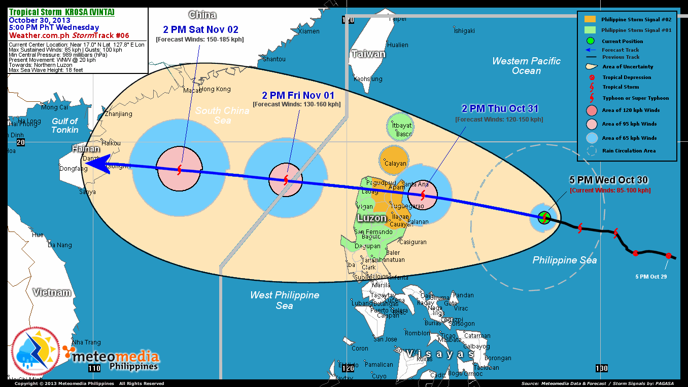
As of 5:00 pm today, the center of TS Krosa (Vinta) was located over the northern part of the Central Philippine Sea...about 540 km northeast of Virac, Catanduanes or 615 km east-northeast of Casiguran, Aurora...currently moving west-northwest with a forward speed of 20 km/hr towards Northern Luzon.
Maximum Sustained Winds (1-min. avg) have increased to 85 km/hr near the center with higher gusts. Tropical Storm Force Winds (63-117 km/hr) extend outward up to 65 kilometers from the center. TS Krosa (Vinta) is a small-sized tropical cyclone with a diameter of 500 kilometers across.
2-DAY FORECAST OUTLOOK*
TS Krosa (Vinta) is expected to maintain a generally west-northwestward movement throughout the forecast period. On the forecast track, the core of TS Krosa (Vinta) will move across the northwestern part of the Central Philippine Sea by Thursday afternoon...approaching the eastern coast of Isabela...and will make landfall over the eastern shores of Cagayan by early Thursday evening. Krosa will cross Northern Luzon thru Cagayan, Apayao and Ilocos Norte by Thursday evening...and will emerge over the west coast of Ilocos Norte early Friday morning.
TS Krosa (Vinta) will continue to gain strength through the next 24 to 48 hours...and could become a Category 1 Typhoon (TY) on Thursday afternoon just before it makes landfall. Advance Intensity Forecast (AIF) shows its 1-minute maximum sustained winds increasing to 120 km/hr on Thursday.
The following is the summary of the 2-day forecast outlook and an extended 3-day forecast on this system:
 THURSDAY AFTERNOON: Strengthens to a typhoon (Category 1) as it approaches the east coast of Cagayan...about 110 km southeast of Santa Ana, Cagayan [2PM OCT 31: 17.9N 123.0E @ 120kph].
FRIDAY AFTERNOON: Exits the Philippine Area of Responsibility (PAR)...reintensifies...after losing strength slightly while crossing Northern Luzon...about 320 km west-northwest of Laoag City, Ilocos Norte [2PM NOV 01: 18.5N 117.6E @ 130kph].
SATURDAY AFTERNOON: Moving across the West Philippine and South China Seas...as it gained more strength...about 375 km south-southwest of Hong Kong, China [2PM NOV 02: 18.9N 113.4E @ 150kph].
*Please be reminded that the Forecast Outlook changes every 6 hours, and the Day 2 and 3 Forecast Track has an average error of 100 and 250 km respectively...while the wind speed forecast error, averages 35 kph per day. Therefore, a turn to the left or right of its future track and changes in its wind speed must be anticipated from time to time.
EFFECTS & HAZARDS SUMMARY
Below is the summary of the storm's parts and its hazards affecting specific areas. You can also view this image link for you to understand the parts.
INNER RAINBANDS - where Tropical Storm Conditions with Tropical Storm Force Winds (63-100 kph) will be expected. Affected Areas: Northern-central part of the Central Philippine Sea. OUTER RAINBANDS - where Tropical Depression Conditions with light, moderate to strong winds (30-62 kph) will be expected. Affected Areas: Northern-central part of the Central Philippine Sea (click here to know more about Rainbands). 24HR TOTAL RAINFALL ACCUMULATION - from 5 up to 100 mm (slight to heavy rainfall) can be expected along areas affected by the outer & inner rainbands (see above)...with isolated amounts of 101 to 200 mm (heavy) along areas near and south of the center of Krosa (Vinta).
Important Note: Please keep in mind that the above forecast outlook, effects and hazards summary changes every 6 to 12 hrs!
CURRENT TECHNICAL INFORMATION
Time/Date: 5:00 PM PhT Wed Oct 30, 2013
Class/Name: TS Krosa (Vinta)
Location of Center: Near 17.0º N Lat 127.8º E Lon
Distance 1: 540 km NE of Virac, Catanduanes
Distance 2: 615 km ENE of Casiguran, Aurora
Distance 3: 615 km ESE of Santa Ana, Cagayan
Distance 4: 650 km ESE of Tuguegarao City
Distance 5: 780 km NE of Metro Manila
MaxWinds (1-min avg): 85 kph near the center
Peak Wind Gusts: 100 kph
Present Movement: WNW @ 20 kph
Towards: Northern Luzon
Minimum Central Pressure: 989 millibars (hPa)
T2K/WP StormTracks (for Public): GIF | Google Map (Flash)
CURRENT TRACKING MAP:
 _____________________________________________________________________________
__________________________________________________________________________________________________
CURRENT NOAA/MTSAT-2 INFRARED (IR) SATELLITE IMAGE:

__________________________________________________________________________________________________
>> To know the meteorological terminologies and acronyms used on this update visit the ff:
http://typhoon2000.ph/tcterm.htm
http://www.nhc.noaa.gov/aboutgloss.shtml
http://www.nhc.noaa.gov/acronyms.shtml
__________________________________________________________________________________________
For the complete details on TS KROSA (VINTA)...go visit our website @:
> http://www.typhoon2000.com
> http://www.maybagyo.com
<<<Typhoon2000.com Mobile >>>
Get the latest SMS Storm Alerts!
For more details: Text T2K TYPHOON to
2800 (Globe/TM) | Offline (Smart/TNT) | 2288 (Sun)
*Only P2.50 (Smart/Globe) / P2.00 (Sun) per msg received.
Click here on how to use this service (in PDF file)
Powered by: Synermaxx Corporation
Copyright © 2013 Typhoon2000.com All Rights Reserved
| Reply via web post | Reply to sender | Reply to group | Start a New Topic | Messages in this topic (1) |

No comments:
Post a Comment