
Typhoon2000 STORM UPDATE #001
Name: TROPICAL STORM RAMMASUN [BUTCHOY/03W/0802]
Issued: 7:00 AM MANILA TIME (23:00 GMT) THU 08 MAY 2008
Source: JTWC TROPICAL CYCLONE WARNING NUMBER 003
Note: Kindly refer to your country's official warnings or bulletins. This update is for additional information purposes only.
Note 2: The Typhoon2000 website including SMS & Email updates will temporary cease updating beginning 11 AM (03
GMT) today until 4 PM (08 GMT) tomorrow. I will be on a Trans-Pacific flight from Los Angeles to Manila after I
attended the 28th Conference on Hurricanes and Tropical Meteorology held last April 28-May 9 in Orlando,
Florida. If you wish to know the latest warnings & bulletins on RAMMASUN, check out the various weather
agencies' links at the main page of our website. Thank you and sorry for the inconvenience, as I am not in
control of the situation.
_____________________________________________________________________________
THE STRONG TROPICAL DISTURBANCE (LPA) OVER THE PHILIPPINE SEA, NEAR
PALAU WHICH BECAME TD 03W, HAS STRENGTHENED INTO TROPICAL STORM
RAMMASUN (BUTCHOY)...MAY POSE A THREAT TO EASTERN PHILIPPINES (FROM
PALAU WHICH BECAME TD 03W, HAS STRENGTHENED INTO TROPICAL STORM
RAMMASUN (BUTCHOY)...MAY POSE A THREAT TO EASTERN PHILIPPINES (FROM
EASTERN LUZON, BICOL DOWN TO EASTERN MINDANAO).
+ FORECAST OUTLOOK: RAMMASUN is expected to turn towards the NNW for
the next 24 hours due to a passing mid-latitude low pressure (aka.
frontal system) South of Japan or north of RAMMASUN. The 3 to 5-day
+ FORECAST OUTLOOK: RAMMASUN is expected to turn towards the NNW for
the next 24 hours due to a passing mid-latitude low pressure (aka.
frontal system) South of Japan or north of RAMMASUN. The 3 to 5-day
long range forecast shows the storm becoming a full-blown Category
2 Typhoon by early Sunday morning, May 11, and accelerating poleward
(Northerly) parallel to the coast of the Philippines (barely 500-
1,000 km. away) through Monday morning, May 12. RAMMASUN shall recurve
to the NE across the Northern Philippine Sea on Tuesday morning before
becoming Extratropical. Majority of the Global Forecast Models conti-
nues to show the storm turning Northward, sparing the Philippines on
a direct hit.
+ EFFECTS: RAMMASUN has maintained a good circulation structure with
most of it spiralling across the Southern Philippine Sea. The western
+ EFFECTS: RAMMASUN has maintained a good circulation structure with
most of it spiralling across the Southern Philippine Sea. The western
outer rain bands of this system continues to spread across Eastern
Mindanao and is expected to reach the coast of Eastern Visayas
later today. People living in low-lying areas must seek higher
grounds for possible flooding due to the anticipated heavy rains
brought about by this system. Precautionary measures must be
fully implemented.
+ TROPICAL CYCLONE WATCH: None.
+ CURRENT ITCZ/MONSOON TROUGH INTENSITY: Moderate to Strong
InterTropical Convergence Zone (ITCZ/Monsoon Trough) continues to
+ TROPICAL CYCLONE WATCH: None.
+ CURRENT ITCZ/MONSOON TROUGH INTENSITY: Moderate to Strong
InterTropical Convergence Zone (ITCZ/Monsoon Trough) continues to
oscillate across much of the Philippines, bringing cloudy skies
with moderate to heavy rains & strong thunderstorms especially in
the afternoon or evening. Landslides, mudflows (lahars) and flooding
is likely to occur along steep mountain/volcano slopes, river banks,
low-lying & flood-prone areas of the affected areas.
Important Note: Please keep in mind that the above forecast outlook,
effects & current monsoon intensity, and tropical cyclone watch changes
every 06 to 12 hours!
_____________________________________________________________________________
TIME/DATE: 5:00 AM MANILA TIME (21:00 GMT) 08 MAY
LOCATION OF CENTER: LATITUDE 8.0º N...LONGITUDE 131.3º E
DISTANCE 1: 670 KM (362 NM) ESE OF SURIGAO CITY, PH
effects & current monsoon intensity, and tropical cyclone watch changes
every 06 to 12 hours!
____________
LOCATION OF CENTER: LATITUDE 8.0º N...LONGITUDE 131.3º E
DISTANCE 1: 670 KM (362 NM) ESE OF SURIGAO CITY, PH
DISTANCE 2: 780 KM (420 NM) SE OF TACLOBAN CITY, PH
DISTANCE 3: 985 KM (530 NM) SE OF VIRAC, CATANDUANES, PH
DISTANCE 4: 1,005 KM (543 NM) SE OF LEGAZPI CITY, PH
DISTANCE 3: 1,080 KM (583 NM) SE OF NAGA CITY, PH
MAX WINDS [1-MIN AVG]: 65 KM/HR (35 KTS) NEAR THE CENTER
PEAK WIND GUSTS: 85 KM/HR (45 KTS)
SAFFIR-SIMPSON SCALE: N/A
MINIMUM CENTRAL PRESSURE (est.): 996 MILLIBARS (hPa)
RECENT MOVEMENT: WNW @ 15 KM/HR (08 KTS)
GENERAL DIRECTION: PHILIPPINE SEA
STORM'S SIZE (IN DIAMETER): 445 KM (240 NM)/AVERAGE
MAX WAVE HEIGHT**: 12 FEET (3.6 METERS)
VIEW TRACKING MAP: 2 AM MANILA TIME THU MAY 08
TSR WIND PROBABILITIES: CURRENT TO 120 HRS LEAD
PHILIPPINE STORM SIGNALS*: N/A
12, 24 & 48 HR. FORECAST:
2 PM (06 GMT) 08 MAY: 8.5N 130.9E / 85-100 KPH / NNW @ 09 KPH
2 AM (18 GMT) 09 MAY: 9.4N 130.6E / 100-130 KPH / N @ 11 KPH
2 AM (18 GMT) 10 MAY: 11.9N 130.1E / 140-165 KPH / N @ 15 KPH
_____________________________________________________________________________
PAGASA CURRENT POSITION, MOVEMENT AND INTENSITY (10-min. ave.):
____________
PAGASA CURRENT POSITION, MOVEMENT AND INTENSITY (10-min. ave.):
> 2 AM (18 GMT) 08 MAY: 8.1N 130.7E / WNW @ 15 KPH / 65 kph
:: For the complete PAGASA bulletin, kindly visit their website at:
http://www.pagasa.dost.gov.ph/wb/tcupdate.shtml
:: For the complete PAGASA bulletin, kindly visit their website at:
http://www.pagasa.
_____________________________________________________________________________
RECENT WUNDERGROUND.COM TRACKING CHART :
RECENT WUNDERGROUND.
________________________
RECENT MTSAT-1R SATELLITE IMAGE:
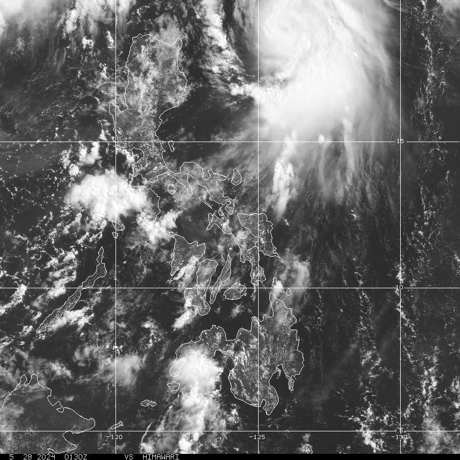
> Image source: NOAA Satellite & Information Service (NESDIS) (http://www.goes.noaa.gov/sohemi/ )
__________________________________________________________________________________________
NOTES:
> Image source: NOAA Satellite & Information Service (NESDIS) (http://www.goes.
____________
^ - JTWC commentary remarks (for Meteorologists) from their
latest warning.
latest warning.
* - Based on PAGASA's Philippine Storm Warning Signals,
# 4 being the highest. Red letters indicate new areas
being hoisted. For more explanations on these signals,
visit: http://www.typhoon2000.ph/signals.htm
** - Based on the Tropical Cyclone's Wave Height near
its center.
__________________________________________________________________________________________
>> To know the meteorological terminologies and acronyms
used on this update visit the ff:
http://typhoon2000.ph/tcterm.htm
http://www.nhc.noaa.gov/aboutgloss.shtml
http://www.srh.noaa.gov/oun/severewx/glossary.php
http://www.srh.weather.gov/fwd/glossarynation.html
http://www.nhc.noaa.gov/acronyms.shtml
__________________________________________________________________________________________
:: Typhoon2000.com (T2K) Mobile >> Powered by: Synermaxx
Receive the latest storm updates directly to your mobile phones! To know more:
Send T2K HELP to: 2800 (GLOBE & TM) | 216 (SMART & TNT) | 2288 (SUN)
Note: Globe & Smart charges P2.50 per message, while Sun at P2.00.
__________________________________________________________________________________________
For the complete details on TS RAMMASUN (03W)...go visit
our website @:
> http://www.typhoon2000.com
> http://www.maybagyo.com
# 4 being the highest. Red letters indicate new areas
being hoisted. For more explanations on these signals,
visit: http://www.typhoon2
** - Based on the Tropical Cyclone's Wave Height near
its center.
____________
>> To know the meteorological terminologies and acronyms
used on this update visit the ff:
http://typhoon2000.
http://www.nhc.
http://www.srh.
http://www.srh.
http://www.nhc.
____________
:: Typhoon2000.
Receive the latest storm updates directly to your mobile phones! To know more:
Send T2K HELP to: 2800 (GLOBE & TM) | 216 (SMART & TNT) | 2288 (SUN)
Note: Globe & Smart charges P2.50 per message, while Sun at P2.00.
For the complete details on TS RAMMASUN (03W)...go visit
our website @:
> http://www.typhoon2
> http://www.maybagyo
Copyright © 2008 Typhoon2000.
Change settings via the Web (Yahoo! ID required)
Change settings via email: Switch delivery to Daily Digest | Switch format to Traditional
Visit Your Group | Yahoo! Groups Terms of Use | Unsubscribe
.
__,_._,___

No comments:
Post a Comment