Typhoon2000 STORM UPDATE #06
Name: TROPICAL STORM JELAWAT [DOMENG/03W/0602]
Issued: 7:00 PM MANILA TIME (11:00 GMT) TUE 27 JUNE 2006
Next Update: 7:00 AM (23:00 GMT) WED 28 JUNE 2006
Source: JTWC TROPICAL CYCLONE WARNING #005
_______________________________________________________________________
Next Update: 7:00 AM (23:00 GMT) WED 28 JUNE 2006
Source: JTWC TROPICAL CYCLONE WARNING #005
_______________________________________________________________________
03W (DOMENG) STRENGTHENS INTO TROPICAL STORM JELAWAT...AIMING
FOR WESTERN GUANGDONG.+ FORECAST OUTLOOK: JELAWAT is expected turn more north-north-
westerly in a heading that would bring the system over Western
Guangdong, Southern China in 36 hours (Thursday early morning).
This system is forecast to reach sustained winds of 85-kph
prior to landfall.
+ EFFECTS: JELAWAT's Inner (Rain) bands remains over the South
China Sea, however, the outer bands are now spreading across
the Island of Hainan and shall reach the coastal areas of
Guangdong late tonight. These rainbands particularly the inner
bands are expected to bring moderate to heavy torrential rains
with strong winds that could produce flying debris, life-threa-
tening flash floods and mudslides along river banks, low-lying
areas and mountain slopes over the affected areas.
+ CURRENT MONSOON INTENSITY: Moderate Southwest Monsoon is being
drawn by this storm towards the western sections of the Phili-
ppines. The affected areas will continue to experience cloudy
skies with light to moderate/heavy rains today.
Important Note: Please keep in mind that the above forecast outlook,
effects & current monsoon intensity changes every 06 to 12 hours!
_______________________________________________________________________
TIME/DATE: 5:00 PM MANILA TIME (09:00 GMT) 27 JUNE
LOCATION OF CENTER: LATITUDE 17.8º N...LONGITUDE 114.5º E
DISTANCE 1: 500 KM (270 NM) SOUTH OF HONG KONG, CHINA
TIME/DATE: 5:00 PM MANILA TIME (09:00 GMT) 27 JUNE
LOCATION OF CENTER: LATITUDE 17.8º N...LONGITUDE 114.5º E
DISTANCE 1: 500 KM (270 NM) SOUTH OF HONG KONG, CHINA
DISTANCE 2: 625 KM (338 NM) WEST OF VIGAN, ILOCOS SUR, PH
DISTANCE 3: 450 KM (243 NM) ESE OF QIONGHAI, HAINAN, CHINA
MAX SUSTAINED WINDS [1-MIN AVG]: 65 KM/HR (35 KTS)
PEAK WIND GUSTS: 85 KM/HR (45 KTS)
MINIMUM CENTRAL PRESSURE (est.): 997 MILLIBARS (hPa)
MAX WAVE HEIGHT**: 14 FEET (4.2 METERS)
SAFFIR-SIMPSON SCALE: N/A
RECENT MOVEMENT: NW @ 17 KM/HR (09 KTS)
GENERAL DIRECTION: WESTERN GUANGDONG
STORM'S SIZE (IN DIAMETER): 400 KM (215 NM)/MEDIUM
VIEW T2K TRACKING MAP: 5 PM TUE JUNE 27
TSR WIND PROBABILITIES: CURRENT TO 120 HRS LEAD
PHILIPPINE STORM SIGNALS*: N/A
09-21 HR. FORECAST:
> 2 AM (18 GMT) 28 JUNE: 18.9N 113.7E / 75-95 KPH
> 2 PM (06 GMT) 28 JUNE: 20.3N 112.8E / 85-100 KPH
REMARKS: 2 PM (06 GMT) 27 JUNE POSITION: 17.4N 114.8E.
^TS JELAWAT IS TRACKING AROUND THE PERIPHERY OF A STRONG
SUBTROPICAL HIGH PRESSURE RIDGE ANCHORED EAST OF OKINAWA.
LANDFALL BETWEEN HAINAN ISLAND AND HONG KONG IS FORECAST
TO OCCUR BETWEEN 36 AND 48 HOURS. THE SYSTEM HAS BEEN
TRACKING QUICKLY OVER THE PAST 24 HOURS, AND MODEL
GUIDANCE HAS BEEN VERIFYING SLOW. GIVEN A CONTINUATION
OF THIS TREND, LANDFALL WILL LEAN TOWARDS EARLIER IN
THE ABOVE TIME FRAME.(more info)
>> JELAWAT {pronounced: jer~la~wa~t}, meaning: Also known
as Sultan fish. This fresh-water carp fish is normally
found in big rivers. It is a very tasty fish and very
much sought after by gourmets. Name contributed by:
Malaysia
_______________________________________________________________________
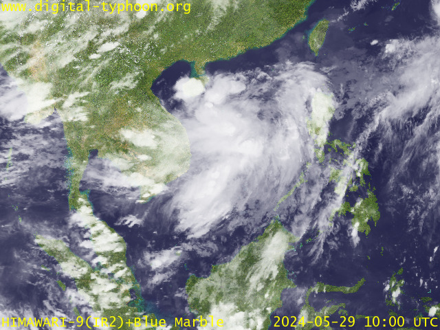
RECENT MTSAT-1R SATELLITE IMAGE:

> Image source: Digital-Typhoon.org (Nat'l. Institute of Informatics) (http://www.digital-typhoon.org)
__________________________________________________________________________________________
LATEST T2K TRACKING CHART:

_______________________________________________________________________________________
NOTES:

> Image source: Digital-Typhoon.org (Nat'l. Institute of Informatics) (http://www.digital-typhoon.org)
__________________________________________________________________________________________
LATEST T2K TRACKING CHART:

_______________________________________________________________________________________
NOTES:
^ - JTWC commentary remarks (for Meteorologists) from their latest warning.
* - Based on PAGASA's Philippine Storm Warning Signals, # 4 being the
highest. Red letters indicate new areas being hoisted. For more
explanations on these signals, visit: http://www.typhoon2000.ph/signals.htm
** - Based on the Tropical Cyclone's Sea Wave Height near its center.
__________________________________________________________________________________________
>> To know the meteorological terminologies and acronyms used on
this update visit the ff:
http://typhoon2000.ph/tcterm.htm
http://www.nhc.noaa.gov/aboutgloss.shtml
http://www.srhnoaa.gov/oun/severewx/glossary.php
http://www.srh.weather.gov/fwd/glossarynation.html
http://www.nhc.noaa.gov/acronyms.shtml
__________________________________________________________________________________________
T2K Mobile: receive the latest storm updates directly to your mobile phones! To know more,
Send T2K HELP to: 2800 (GLOBE & TM) | OFFLINE (SMART & TNT) | 2288 (SUN)
Powered by: Synermaxx
__________________________________________________________________________________________
For the complete details on the TS JELAWAT (DOMENG/03W)...go visit our website @:
> http://www.typhoon2000.com
> http://www.maybagyo.com
:: Kindly view our site's disclaimer at: http://www.typhoon2000.ph/disclaimer.htm
Visit Your Group | Yahoo! Groups Terms of Use | Unsubscribe
SPONSORED LINKS
.
__,_._,___
No comments:
Post a Comment