Typhoon2000 STORM UPDATE #03
Name: TROPICAL STORM DOMENG [92W]
Issued: 7:00 AM MANILA TIME (23:00 GMT) MON 26 JUNE 2006
Next Update: 7:00 PM (11:00 GMT) MON 26 JUNE 2006
Source: PAGASA BULLETIN-WARNING #008
_______________________________________________________________________
Next Update: 7:00 PM (11:00 GMT) MON 26 JUNE 2006
Source: PAGASA BULLETIN-WARNING #008
_______________________________________________________________________
TROPICAL STORM DOMENG IS NOW MOVING OUT INTO THE SOUTH CHINA SEA
AFTER CROSSING NORTHERN VISAYAS YESTERDAY.
+ FORECAST OUTLOOK: DOMENG is expected to continue tracking into
the South China Sea today. This system is likely to intensify
further upon reaching the South China Sea.
+ EFFECTS: DOMENG's Inner Rainbands continues to affect Calamian
Group & Lubang Island while its Outer Bands continues to spread
across Western Luzon and Palawan. These rainbands particularly
the inner bands are expected to bring moderate to heavy torren-
tial rains with strong winds that could produce flying debris,
life-threatening flash floods and mudslides along river banks,
low-lying areas and mountain slopes over the affected areas.
+ CURRENT MONSOON INTENSITY: Light Southwest Monsoon is being
drawn by this storm towards western sections of Visayas and
Mindanao. The affected areas will continue to experience cloudy
skies with light to moderate/heavy rains today.
Important Note: Please keep in mind that the above forecast outlook,
effects & current monsoon intensity changes every 06 to 12 hours!
_______________________________________________________________________
TIME/DATE: 4:00 AM MANILA TIME (20:00 GMT) 26 JUNE
LOCATION OF CENTER: LATITUDE 14.0º N...LONGITUDE 118.9º E
DISTANCE 1: 250 KM (135 NM) WNW OF CALAPAN, ORIENTAL MINDORO, PH
TIME/DATE: 4:00 AM MANILA TIME (20:00 GMT) 26 JUNE
LOCATION OF CENTER: LATITUDE 14.0º N...LONGITUDE 118.9º E
DISTANCE 1: 250 KM (135 NM) WNW OF CALAPAN, ORIENTAL MINDORO, PH
DISTANCE 2: 235 KM (127 NM) WSW OF MANILA, PH
DISTANCE 3: 160 KM (85 NM) SW OF SUBIC, ZAMBALES, PH
MAX SUSTAINED WINDS [10-MIN AVG]: 75 KM/HR (40 KTS)
PEAK WIND GUSTS: 90 KM/HR (48 KTS)
MINIMUM CENTRAL PRESSURE (est.): 994 MILLIBARS (hPa)
MAX WAVE HEIGHT**: 08 FEET (2.4 METERS)
SAFFIR-SIMPSON SCALE: N/A
RECENT MOVEMENT: WNW @ 22 KM/HR (12 KTS)
GENERAL DIRECTION: SOUTH CHINA SEA
STORM'S SIZE (IN DIAMETER): 400 KM (215 NM)/MEDIUM
VIEW T2K TRACKING MAP: 4 AM MON JUNE 26
TSR WIND PROBABILITIES: N/A
PHILIPPINE STORM SIGNALS*:
#02 - LUBANG ISLAND.
#01 - MINDORO PROVINCES, BATANGAS, CAVITE, BATAAN &
NORTHERN PALAWAN.
09-21 HR. FORECAST:
> 2 PM (06 GMT) 26 JUNE: 14.9N 116.9E [Over South China Sea]
> 2 AM (18 GMT) 27 JUNE: 16.6N 115.0E [Over South China Sea]
REMARKS: 2 AM (18 GMT) 26 JUNE POSITION: 13.9N 119.3E.
_________________________________________________________________________________
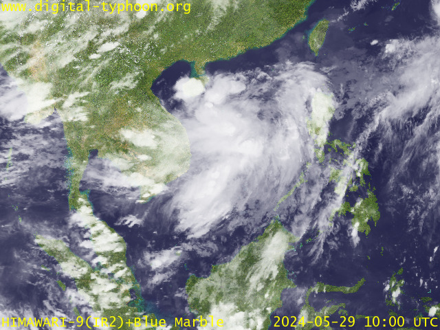
RECENT MTSAT-1R SATELLITE IMAGE:

> Image source: Digital-Typhoon.org (Nat'l. Institute of Informatics) (http://www.digital-typhoon.org)
__________________________________________________________________________________________
LATEST T2K TRACKING CHART:

_______________________________________________________________________________________
NOTES:

> Image source: Digital-Typhoon.org (Nat'l. Institute of Informatics) (http://www.digital-typhoon.org)
__________________________________________________________________________________________
LATEST T2K TRACKING CHART:

_______________________________________________________________________________________
NOTES:
^ - JTWC commentary remarks (for Meteorologists) from their latest warning.
* - Based on PAGASA's Philippine Storm Warning Signals, # 4 being the
highest. Red letters indicate new areas being hoisted. For more
explanations on these signals, visit: http://www.typhoon2000.ph/signals.htm
** - Based on the Tropical Cyclone's Sea Wave Height near its center.
__________________________________________________________________________________________
>> To know the meteorological terminologies and acronyms used on
this update visit the ff:
http://typhoon2000.ph/tcterm.htm
http://www.nhc.noaa.gov/aboutgloss.shtml
http://www.srhnoaa.gov/oun/severewx/glossary.php
http://www.srh.weather.gov/fwd/glossarynation.html
http://www.nhc.noaa.gov/acronyms.shtml
__________________________________________________________________________________________
T2K Mobile: receive the latest storm updates directly to your mobile phones! To know more,
Send T2K HELP to: 2800 (GLOBE & TM) | OFFLINE (SMART & TNT) | 2288 (SUN)
Powered by: Synermaxx
__________________________________________________________________________________________
For the complete details on the TS DOMENG (92W)...go visit our website @:
> http://www.typhoon2000.com
> http://www.maybagyo.com
:: Kindly view our site's disclaimer at: http://www.typhoon2000.ph/disclaimer.htm
Visit Your Group | Yahoo! Groups Terms of Use | Unsubscribe
SPONSORED LINKS
.
__,_._,___
No comments:
Post a Comment