Typhoon2000 STORM UPDATE #09 **FINAL**
Name: TROPICAL DEPRESSION JELAWAT [DOMENG/03W/0602]
Issued: 7:00 AM MANILA TIME (23:00 GMT) THU 29 JUNE 2006
Source: JTWC TROPICAL CYCLONE WARNING #011
_______________________________________________________________________
Source: JTWC TROPICAL CYCLONE WARNING #011
_______________________________________________________________________
JELAWAT (DOMENG) LOSES STRENGTH AND WEAKENED INTO A TROPICAL
DEPRESSION
...TO MAKE LANDFALL OVER WESTERN GUANGDONG THISDEPRESSION
AFTERNOON.
...THIS IS THE FINAL UPDATE ON THIS SYSTEM.
+ FORECAST OUTLOOK: JELAWAT is expected to make landfall over
Western Guangdong this afternoon and dissipate rapidly overland.
+ EFFECTS: JELAWAT's main core (inner rain bands) is still dis-
placed SW of its center and continues to engulf the whole Hainan
Island including the coastal areas of Western Guangdong with
winds and heavy rainfall. Life-threatening flash floods and mud-
slides along swelling river banks, low-lying areas and mountain
slopes can be expected. Improving weather conditions can be ex-
pected late today as the system dissipates over China.
+ CURRENT MONSOON INTENSITY: Southwest Monsoon retreating over
the South China Sea and is just lightly affecting Palawan, Sulu
Sea and portions of Western Philippines.
+ TROPICAL CYCLONE WATCH: The new Low Pressure Area (aka. Tropical
Disturbance) over the Caroline Islands has become active and con-
tinues to strengthen as it moves WNW slowly. The system was located
some 1,595 km ESE of Mindanao (4.4N 140.7E) and is likely to become
a significant Tropical Cyclone within the next 24 to 48 hours. Stay
tuned for more updates on this disturbance.
effects & current monsoon intensity changes every 06 to 12 hours!
_______________________________________________________________________
TIME/DATE: 5:00 AM MANILA TIME (21:00 GMT) 29 JUNE
LOCATION OF CENTER: LATITUDE 20.6º N...LONGITUDE 110.8º E
DISTANCE 1: 75 KM (40 NM) NE OF HAIKOU, HAINAN ISLAND, CHINA
TIME/DATE: 5:00 AM MANILA TIME (21:00 GMT) 29 JUNE
LOCATION OF CENTER: LATITUDE 20.6º N...LONGITUDE 110.8º E
DISTANCE 1: 75 KM (40 NM) NE OF HAIKOU, HAINAN ISLAND, CHINA
DISTANCE 2: 90 KM (48 NM) SSE OF ZHANJIANG CHINA
DISTANCE 3: 400 KM (215 NM) WSW OF HONG KONG, CHINA
MAX SUSTAINED WINDS [1-MIN AVG]: 55 KM/HR (30 KTS)
PEAK WIND GUSTS: 75 KM/HR (40 KTS)
MINIMUM CENTRAL PRESSURE (est.): 1000 MILLIBARS (hPa)
MAX WAVE HEIGHT**: 12 FEET (3.6 METERS)
SAFFIR-SIMPSON SCALE: N/A
RECENT MOVEMENT: NW @ 09 KM/HR (05 KTS)
GENERAL DIRECTION: WESTERN GUANGDONG
STORM'S SIZE (IN DIAMETER): 260 KM (140 NM)/SMALL
VIEW T2K TRACKING MAP: 5 AM THU JUNE 29
TSR WIND PROBABILITIES: CURRENT TO 24 HRS LEAD
PHILIPPINE STORM SIGNALS*: N/A
09-21 HR. FORECAST:
> 2 PM (06 GMT) 29 JUNE: 21.2N 110.2E / 45-65 KPH [Landfall]
> 2 AM (18 GMT) 30 JUNE: 22.3N 109.6E / 35-55 KPH [Dissipating]
REMARKS: 2 AM (18 GMT) 29 JUNE POSITION: 20.4N 111.0E.
^ TD JELAWAT IS TRACKING NORTH-NORTHWESTWARD AROUND A LOW TO
MID LEVEL HIGH PRESSURE RIDGE. ANIMATED ENHANCED INFRARED
IMAGERY AND A 6:39 PM JUNE 28 SATELLITE PASS REVEAL THE LOW
LEVEL CENTER AND THE MID LEVEL CONVECTION ARE BEING SHEARED
APART DUE TO EASTERLY FLOW IN THE MID LEVEL AND SOUTHEASTER-
LY FLOW IN THE LOW LEVEL. THE SYSTEM IS EXPECTED TO MAKE
LANDFALL BY 06 TO 12 HOURS.(more info)
>> JELAWAT {pronounced: jer~la~wa~t}, meaning: Also known
as Sultan fish. This fresh-water carp fish is normally
found in big rivers. It is a very tasty fish and very
much sought after by gourmets. Name contributed by:
Malaysia
_______________________________________________________________________
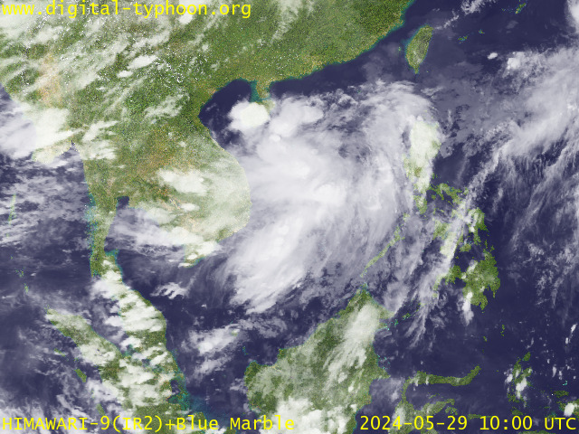
RECENT MTSAT-1R SATELLITE IMAGE:

> Image source: Digital-Typhoon.org (Nat'l. Institute of Informatics) (http://www.digital-typhoon.org)
__________________________________________________________________________________________
LATEST T2K TRACKING CHART:

_______________________________________________________________________________________
NOTES:

> Image source: Digital-Typhoon.org (Nat'l. Institute of Informatics) (http://www.digital-typhoon.org)
__________________________________________________________________________________________
LATEST T2K TRACKING CHART:

_______________________________________________________________________________________
NOTES:
^ - JTWC commentary remarks (for Meteorologists) from their latest warning.
* - Based on PAGASA's Philippine Storm Warning Signals, # 4 being the
highest. Red letters indicate new areas being hoisted. For more
explanations on these signals, visit: http://www.typhoon2000.ph/signals.htm
** - Based on the Tropical Cyclone's Sea Wave Height near its center.
__________________________________________________________________________________________
>> To know the meteorological terminologies and acronyms used on
this update visit the ff:
http://typhoon2000.ph/tcterm.htm
http://www.nhc.noaa.gov/aboutgloss.shtml
http://www.srhnoaa.gov/oun/severewx/glossary.php
http://www.srh.weather.gov/fwd/glossarynation.html
http://www.nhc.noaa.gov/acronyms.shtml
__________________________________________________________________________________________
T2K Mobile: receive the latest storm updates directly to your mobile phones! To know more,
Send T2K HELP to: 2800 (GLOBE & TM) | OFFLINE (SMART & TNT) | 2288 (SUN)
Powered by: Synermaxx
__________________________________________________________________________________________
For the complete details on the TD JELAWAT (DOMENG/03W)...go visit our website @:
> http://www.typhoon2000.com
> http://www.maybagyo.com
:: Kindly view our site's disclaimer at: http://www.typhoon2000.ph/disclaimer.htm
Visit Your Group | Yahoo! Groups Terms of Use | Unsubscribe
SPONSORED LINKS
.
__,_._,___
No comments:
Post a Comment