
for Sunday, 29 September 2013 [10:00 AM PhT]
WEATHER.COM.PH TROPICAL CYCLONE UPDATES
TYPHOON WUTIP (PAOLO) UPDATE NUMBER 005
Issued at: 7:30 AM PhT (23:30 GMT) Sunday 29 September 2013
WUTIP (PAOLO) becomes a Typhoon (TY) as it continues to drift slowly westward across the South China Sea...threat to Central Vietnam increases.
Meanwhile, Tropical Disturbance (LPA) 95W has reorganized over the southern portion of the Philippine Sea...just along the eastern boundary of the Philippine Area of Responsibility (PAR). Its center was located about 1,040 km east-southeast of Borongan City, Samar (11.0N Lat 134.9E Lon)...with maximum winds of 35 km/hr near the center...currently quasi-stationary during the past 12 hours. Various forecast models suggest this system could become a Tropical Cyclone within the next 24 to 48 hours with a northerly track across the open seas of the Western Pacific Ocean...and is not a threat to the Philippines. This disturbance has a medium chance (30-50%) of developing into a Tropical Cyclone within the next 24 hours.
Residents and visitors along the coastal areas of Central Vietnam and Hainan Island should closely monitor the development of Wutip (Paolo).
Do not use this for life or death decisions. This update is intended for additional information purposes only. Kindly refer to your national weather agency for official warnings, advisories or bulletins.
CURRENT STORM ANALYSIS
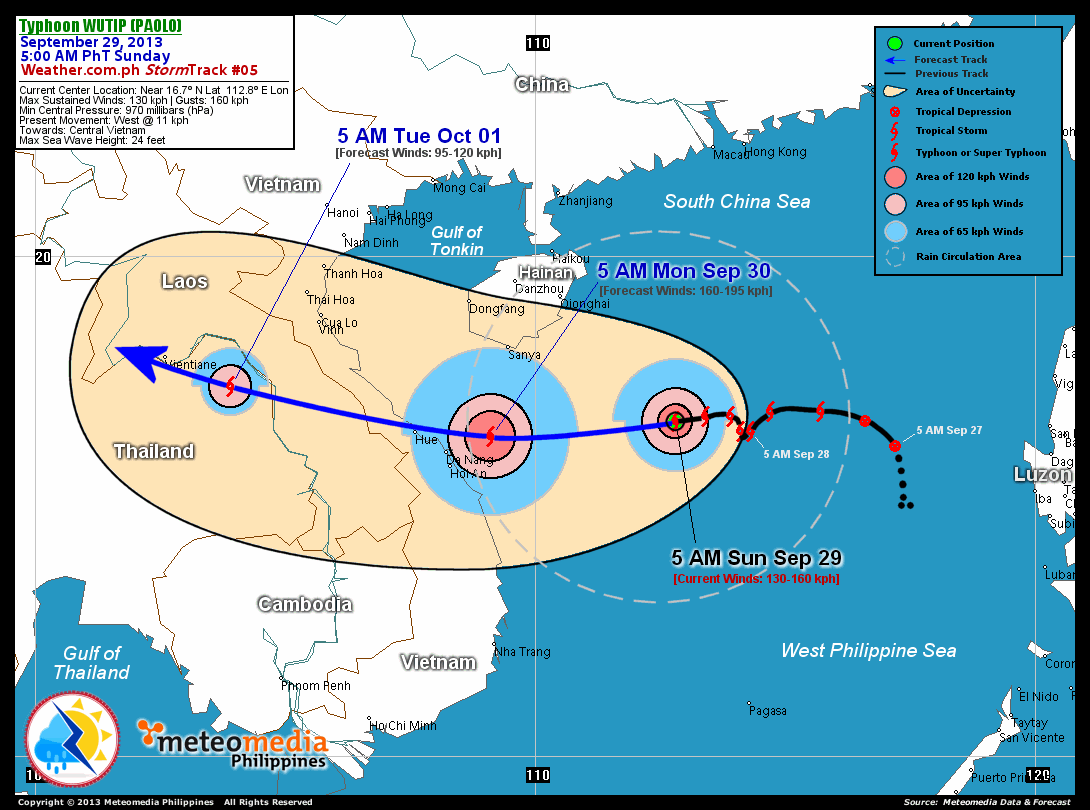
As of 5:00 am today, the eye of TY Wutip (Paolo) was located over the western part of the South China Sea...about 390 km southeast of Sanya, Hainan Island or 495 km east-northeast of Da Nang, Vietnam...currently moving westward with a forward speed of 11 km/hr towards Central Vietnam.
Maximum Sustained Winds (1-min. avg) have increased to 130 km/hr near the center with higher gusts. Typhoon Force Winds (118 km/hr or more) extend outward up to 35 kilometers from the center...and Tropical Storm Force Winds (63-117 km/hr) extend outward up to 140 kilometers. Wutip (Paolo) remains an average-sized tropical cyclone with a diameter of 610 kilometers across. The 24-hour rainfall accumulation near the center of WUTIP (Paolo) is estimated to be extreme (400 mm).
2-DAY FORECAST OUTLOOK*
TY Wutip (Paolo) is expected to move west-southwest to west during the next 24 hours...with a turn to the west-northwest through 48 hours. On the forecast track, the core of Wutip (Paolo) will make landfall over Central Vietnam, over or very near Hue City on or before noon on Monday...and will traverse the rugged terrain of Laos on Monday evening. By Tuesday morning, it will be over the eastern portion of Thailand.
TY Wutip (Paolo) will continue to gain strength during the next 24 hours...and will be downgraded into a Tropical Storm (TS) by 48 hours. Advance Intensity Forecast (AIF) shows its 1-minute maximum sustained winds increasing to 160 km/hr by Monday morning.
The following is the summary of the 2-day forecast outlook on this system:
 MONDAY MORNING: Intensifies to Category 2 Typhoon as it moves over the coast of Central Vietnam...about 100 km east-northeast of Da Nang, Vietnam [5AM SEP 30: 16.4N 109.1E @ 160kph].
TUESDAY MORNING: Weakens to a TS as it moves across Eastern Thailand...about 105 km east-southeast of Vientiane, Laos [5AM OCT 01: 17.4N 103.9E @ 95kph].
*Please be reminded that the Forecast Outlook changes every 6 hours, and the Day 2 and 3 Forecast Tracks have an average error of 100 and 250 km respectively...while the wind speed forecast error, averages 35 kph per day. Therefore, a turn to the left or right of its future track and changes in its wind speed must be anticipated from time to time.
EFFECTS & HAZARDS SUMMARY
Below is the summary of the storm's parts and its hazards affecting specific areas. You can also view this image link for you to understand the parts.
CLOUD-FILLED EYE - Over the western part of the South China Sea. Possible calm and lull conditions (with <20 kph winds) will be expected inside the eye (click here to know more about the EYE). EYEWALL - where Typhoon Conditions with Typhoon Force Winds (>118 kph) will be expected within this wall. Affected Areas: Over the western part of the South China Sea (click here to know more about the Eyewall). INNER RAINBANDS - where Tropical Storm Conditions with Tropical Storm Force Winds (63-100 kph) will be expected. Affected Areas: Western portions of the South China Sea Sea. OUTER RAINBANDS - where Tropical Depression Conditions with light, moderate to strong winds (30-62 kph) will be expected. Affected Areas: Hainan Island and the coastal areas of Central Vietnam (click here to know more about Rainbands). 24HR TOTAL RAINFALL ACCUMULATION - from 5 up to 100 mm (slight to heavy rainfall) can be expected along areas affected by the outer & inner rainbands (see above)...with isolated amounts of 101 to 400 mm (heavy to extreme) along areas near the center of Wutip (Paolo). COASTAL STORM SURGE FLOODING - possible 4-5 ft (1.2-1.7 m) above normal tide levels...accompanied by large and dangerous battering waves can be expected along the coastal, inland lakes and beach front areas of Southern Hainan and Central Vietnam today and early Monday. Minimal damage is likely on this type of storm surge. Danger from Rip Currents or Rip Tides can be expected along the rest of the beach-front areas of Hainan Island and Vietnam (click here to know more about Storm Surge).
Important Note: Please keep in mind that the above forecast outlook, effects and hazards summary changes every 6 to 12 hrs!
CURRENT TECHNICAL INFORMATION
Time/Date: 5:00 AM PhT Sun Sep 29, 2013
Class/Name: TY Wutip (Paolo)
Location of Eye: Near 16.7º N Lat 112.8º E Lon
Distance 1: 390 km SE of Sanya, Hainan Is.
Distance 2: 490 km ENE of Hoi An, Vietnam
Distance 3: 495 km ENE of Da Nang, Vietnam
Distance 4: 555 km E of Hue, Vietnam
Distance 5: 785 km ESE of Vinh, Vietnam
MaxWinds (1-min avg): 130 kph near the center
Peak Wind Gusts: 160 kph
Saffir-Simpson Hurricane Scale: Category 1
Present Movement: W @ 11 kph
Towards: Central Vietnam
24hr Rainfall Accum (Near the Center): Extreme [400 mm]
Minimum Central Pressure: 970 millibars (hPa)
Size (in Diameter): 610 km [Average]
Max Sea Wave Height (near center): 24 feet
Possible Storm Surge Height: 4-5 ft (1.2-1.7 m)
T2K/WP StormTracks (for Public): GIF | Google Map (Flash)
CURRENT TRACKING MAP:
 _____________________________________________________________________________
__________________________________________________________________________________________________
CURRENT NOAA/MTSAT-2 INFRARED (IR) SATELLITE IMAGE:

__________________________________________________________________________________________________
>> To know the meteorological terminologies and acronyms used on this update visit the ff:
http://typhoon2000.ph/tcterm.htm
http://www.nhc.noaa.gov/aboutgloss.shtml
http://www.nhc.noaa.gov/acronyms.shtml
__________________________________________________________________________________________
For the complete details on TY WUTIP (PAOLO)...go visit our website @:
> http://www.typhoon2000.com
> http://www.maybagyo.com
<<<Typhoon2000.com Mobile >>>
Get the latest SMS Storm Alerts!
For more details: Text T2K TYPHOON to
2800 (Globe/TM) | Offline (Smart/TNT) | 2288 (Sun)
*Only P2.50 (Smart/Globe) / P2.00 (Sun) per msg received.
Click here on how to use this service (in PDF file)
Powered by: Synermaxx Corporation
Copyright © 2013 Typhoon2000.com All Rights Reserved
| Reply via web post | Reply to sender | Reply to group | Start a New Topic | Messages in this topic (1) |

No comments:
Post a Comment