
for Friday, 27 September 2013 [8:10 PM PhT]
WEATHER.COM.PH TROPICAL CYCLONE UPDATES
TROPICAL STORM WUTIP (PAOLO) UPDATE NUMBER 002
Issued at: 7:00 PM PhT (11:00 GMT) Friday 27 September 2013
20W (PAOLO) has intensified into a Tropical Storm...internationally named as WUTIP (Macao name of butterfly) as it accelerated and moved out from the Philippine Area of Responsibility (PAR). It is likely to threaten Vietnam early next week.
This storm will slightly enhance the Southwest Monsoon (Hanging Habagat) - bringing mostly cloudy and breezy conditions with occasional slight to moderate to sometimes heavy rains or thunderstorms across the western sections of Central Luzon, Metro Manila, MiMaRoPa, Spratly Islands and CaLaBaRZon tonight. The threat of flash floods and landslides are likely in hazard-prone areas especially along river banks and mountain slopes of the affected areas. Residents are advised to take necessary precautions.
Meanwhile, Tropical Disturbance (LPA) 95W continues to consolidate. Its center was located about 505 km ENE of Surigao City or 515 km ESE of Borongan, Samar (10.0N Lat 134.0E Lon)...with maximum winds of 35 km/hr near the center...currently moving WSW at 22 kph. Various forecast models suggest this system could become a Tropical Cyclone within the next 24 to 48 hours with a northward track across the Philippine Sea...and is not yet a threat to the Philippines. This disturbance has a medium chance (30-50%) of developing into a Tropical Cyclone within the next 24 hours.
Residents and visitors along the coastal areas of Central Vietnam and Hainan Island should closely monitor the development of WUTIP (Paolo).
Do not use this for life or death decisions. This update is intended for additional information purposes only. Kindly refer to your national weather agency for official warnings, advisories or bulletins.
CURRENT STORM ANALYSIS
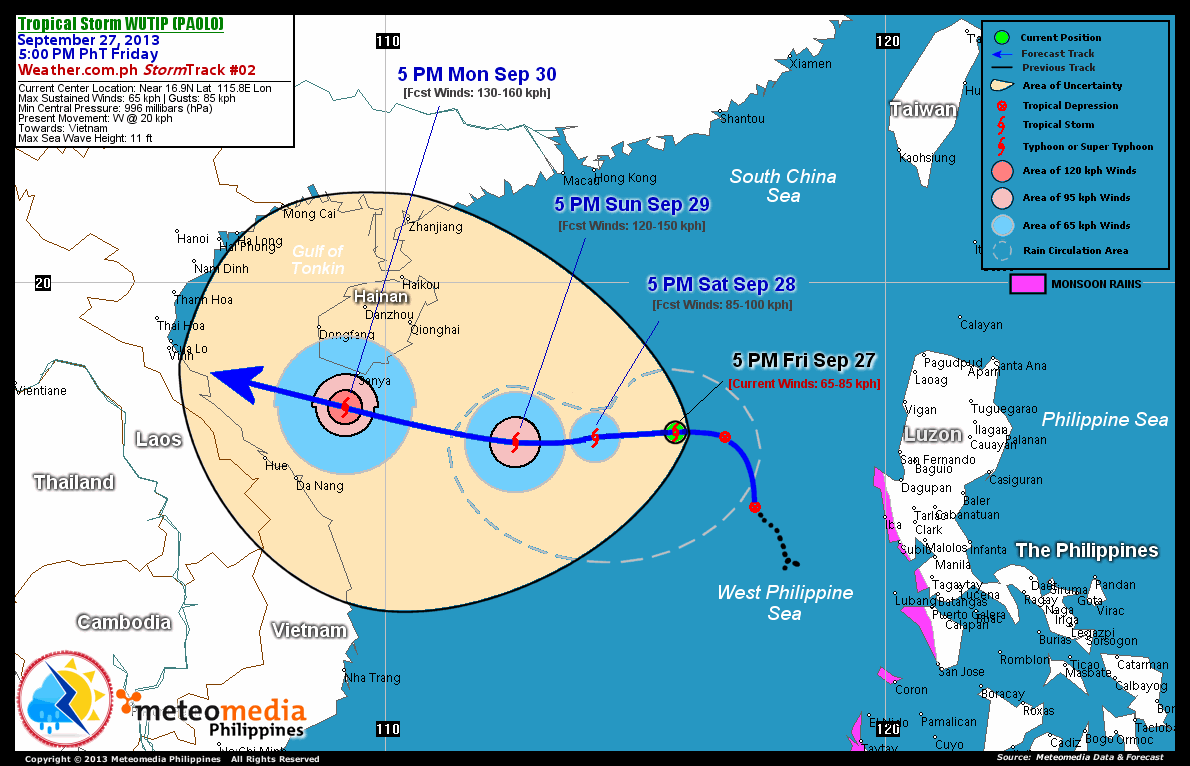
As of 5:00 pm today, the center of TS WUTIP (Paolo) was located over the West Philippine Sea...about 540 km northwest of Subic Bay, Zambales or 815 km east-northeast of Da Nang, Vietnam...currently moving west with increasing forward speed of 20 km/hr towards Vietnam.
Maximum Sustained Winds (1-min. avg) are at 65 km/hr near the center with higher gusts. Wutip (Paolo) has grown into an average-sized tropical cyclone with a diameter of 555 kilometers across. The 24-hour rainfall accumulation near the center of WUTIP (Paolo) is estimated to be heavy (250 mm).
2-DAY FORECAST OUTLOOK*
TS WUTIP (Paolo) is expected to continue moving west during the next 24 hours...with a turn to the west-southwest and back to west through 48 hours. On the forecast track, the core of WUTIP (Paolo) will be moving over the western part of the South China Sea, east of Central Vietnam thru Sunday.
TS WUTIP (Paolo) will further gain strength during the next 24 to 48 hours...and could become a Typhoon (TY) on Sunday afternoon. Advance Intensity Forecast (AIF) shows its 1-minute maximum sustained winds increasing to 120 km/hr on Sunday afternoon.
The following is the summary of the 2-day forecast outlook and an extended 3-day forecast on this system:
 SATURDAY AFTERNOON: Intensifies further as a TS as it moves across the central part of the South China Sea...about 700 km west-northwest of Dagupan City, Pangasinan [5PM SEP 28: 16.9N 114.2E @ 85kph].
SUNDAY AFTERNOON: Intensifies into a Typhoon (Category 1) as it turns slightly west-southwest then back to west slowly across the South China Sea...about 475 km east-northeast of Da Nang, Vietnam [5PM SEP 29: 16.8N 112.6E @ 120kph].
MONDAY AFTERNOON: Strengthens further as a Category 1 Typhoon...moving closer to the coast of Central Vietnam...about 80 km south-southwest of Sanya, Hainan [5PM SEP 30: 17.5N 109.2E @ 130kph].
*Please be reminded that the Forecast Outlook changes every 6 hours, and the Day 2 and 3 Forecast Tracks have an average error of 100 and 250 km respectively...while the wind speed forecast error, averages 35 kph per day. Therefore, a turn to the left or right of its future track and changes in its wind speed must be anticipated from time to time.
EFFECTS & HAZARDS SUMMARY
Below is the summary of the storm's parts and its hazards affecting specific areas. You can also view this image link for you to understand the parts.
INNER RAINBANDS - where Tropical Storm Conditions with Tropical Storm Force Winds (63-100 kph) will be expected. Affected Areas: Western portion of West Philippine Sea. OUTER RAINBANDS - where Tropical Depression Conditions with light, moderate to strong winds (30-62 kph) will be expected. Affected Areas: Central portion of the West Philippine Sea and Scarborough (Panatag) Shoal (click here to know more about Rainbands). 24HR TOTAL RAINFALL ACCUMULATION - from 5 up to 100 mm (slight to heavy rainfall) can be expected along areas affected by the outer & inner rainbands (see above)...with isolated amounts of 101 to 250 mm (heavy) along areas near the center of WUTIP (Paolo).
Important Note: Please keep in mind that the above forecast outlook, effects and hazards summary changes every 6 to 12 hrs!
CURRENT TECHNICAL INFORMATION
Time/Date: 5:00 PM PhT Fri Sep 27, 2013
Class/Name: TS Wutip (Paolo)
Location of Center: Near 16.9º N Lat 115.8º E Lon
Distance 1: 485 km WNW of Iba, Zambales
Distance 2: 490 km WNW of Dagupan City
Distance 3: 540 km NW of Subic Bay
Distance 4: 620 km NW of Metro Manila
Distance 5: 815 km ENE of Da Nang, Vietnam
MaxWinds (1-min avg): 65 kph near the center
Peak Wind Gusts: 85 kph
Present Movement: W @ 20 kph
Towards: Vietnam
24hr Rainfall Accum (Near the Center): Heavy [250 mm]
Minimum Central Pressure:996 millibars (hPa)
Size (in Diameter): 555 km [Average]
Max Sea Wave Height (near center): 11 feet
T2K/WP StormTracks (for Public): GIF | Google Map (Flash)
CURRENT TRACKING MAP:
 _____________________________________________________________________________
__________________________________________________________________________________________________
CURRENT NOAA/MTSAT-2 INFRARED (IR) SATELLITE IMAGE:

__________________________________________________________________________________________________
>> To know the meteorological terminologies and acronyms used on this update visit the ff:
http://typhoon2000.ph/tcterm.htm
http://www.nhc.noaa.gov/aboutgloss.shtml
http://www.nhc.noaa.gov/acronyms.shtml
__________________________________________________________________________________________
For the complete details on TS WUTIP (PAOLO)...go visit our website @:
> http://www.typhoon2000.com
> http://www.maybagyo.com
<<<Typhoon2000.com Mobile >>>
Get the latest SMS Storm Alerts!
For more details: Text T2K TYPHOON to
2800 (Globe/TM) | Offline (Smart/TNT) | 2288 (Sun)
*Only P2.50 (Smart/Globe) / P2.00 (Sun) per msg received.
Click here on how to use this service (in PDF file)
Powered by: Synermaxx Corporation
Copyright © 2013 Typhoon2000.com All Rights Reserved
| Reply via web post | Reply to sender | Reply to group | Start a New Topic | Messages in this topic (1) |

No comments:
Post a Comment