
for Saturday, 14 September 2013 [8:57 AM PhT]
WEATHER.COM.PH TROPICAL CYCLONE UPDATES
TROPICAL STORM MAN-YI (16W) UPDATE NUMBER 003
Issued at: 7:30 AM PhT (23:30 GMT) Saturday 14 September 2013
Tropical Storm MAN-YI (16W) getting stronger as it moves west-northwest across the sea south of Japan...continues to threaten Southern Japan.
Residents and visitors along Southern Japan should closely monitor the development of Man-yi (16W).
Do not use this for life or death decisions. This update is intended for additional information purposes only. Kindly refer to your national weather agency for official warnings, advisories or bulletins.
CURRENT STORM ANALYSIS
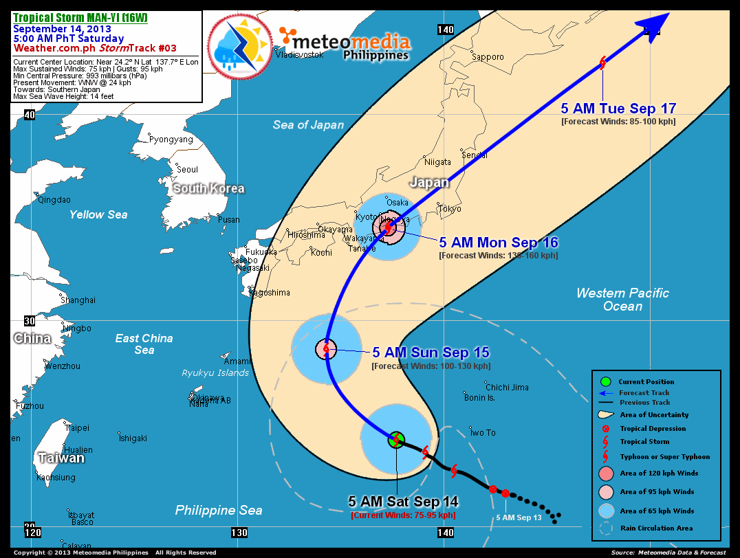
As of 5:00 am today, the center of TS Man-yi (16W) was located over the Western Pacific Ocean...about 370 km west-southwest of Iwo To, Japan or 1,665 km east-northeast of Basco, Batanes...currently moving west-northwest with a forward speed of 24 km/hr towards Southern Japan.
Maximum Sustained Winds (1-min. avg) have increased to 75 km/hr near the center with higher gusts. Tropical Storm Force Winds (63-95 km/hr) extend outward up to 195 kilometers from the center. Man-yi (16W) has grown into a very large-sized tropical cyclone with a diameter of 945 kilometers across. The 24-hour rainfall accumulation near the center of Man-yi is estimated to be extreme (400 mm).
2-DAY FORECAST OUTLOOK*
TS Man-yi (16W) is expected to move northwest during the next 12 hours...with a gradual turn to the north by 24 hours. By 48 hours, the system will rapidly accelerate as it recurves northeasterly. On the forecast track, the core of Man-Yi will be approaching the southern shores of Honshu on Sunday...and making landfall over Aichi and Shizouka Prefectures in Honshu, Japan by Monday morning.
TS Man-yi will continue to strengthen during the next 48 hours...and could become a Typhoon on Saturday afternoon. Advance Intensity Forecast (AIF) shows its 1-minute sustained winds reaching 130 km/hr prior in making landfall to Southern Honshu.
The following is the summary of the 2-day forecast outlook and an extended 3-day forecast on this system:
 SUNDAY MORNING: Continues to intensify as it recurves northward...about 560 km south of Kochi, Japan [5AM SEP 15: 28.6N 134.3E @ 100kph].
MONDAY MORNING: Just along the shores of Southern Honshu...becomes a Typhoon...about 85 km south-southeast of Nagoya, Japan [5AM SEP 16: 34.5N 137.3E @ 130kph].
TUESDAY MORNING: Becomes an Extratropical Cyclone as it accelerates across the Western Pacific Ocean...losing strength...about 515 km east-southeast of Sapporo, Japan [5AM SEP 17: 42.5N 147.7E @ 85kph].
*Please be reminded that the Forecast Outlook changes every 6 hours, and the Day 2 and 3 Forecast Tracks have an average error of 100 and 250 km respectively...while the wind speed forecast error, averages 35 kph per day. Therefore, a turn to the left or right of its future track and changes in its wind speed must be anticipated from time to time.
EFFECTS HAZARDS SUMMARY
Below is the summary of the storm's parts and its hazards affecting specific areas. You can also view this image link for you to understand the parts.
INNER RAINBANDS - where Tropical Storm Conditions with Tropical Storm Force Winds (63-95 kph) will be expected. Affected Areas: None (Over Western Pacific Ocean). OUTER RAINBANDS - where Tropical Depression Conditions with light, moderate to strong winds (30-62 kph) will be expected. Affected Areas: Iwo To, Bonin and Chichijima Islands (click here to know more about Rainbands). 24HR TOTAL RAINFALL ACCUMULATION - from 5 up to 100 mm (slight to heavy rainfall) can be expected along areas affected by the outer inner rainbands (see above)...with isolated amounts of 101 to 400 mm (heavy to extreme) along areas to the north, northwest and near the center of Man-yi (16W).
Important Note: Please keep in mind that the above forecast outlook, effects and hazards summary changes every 6 to 12 hrs!
CURRENT TECHNICAL INFORMATION
Time/Date: 5:00 AM PhT Sat Sep 14, 2013
Class/Name: TS Man-yi (16W)
Location of Center: Near 24.2º N Lat 137.7º E Lon
Distance 1: 370 km WSW of Iwo To, Japan
Distance 2: 530 km SW of Chichijima
Distance 3: 1025 km ESE of Okinawa, Japan
Distance 4: 1295 km SSW of Tokyo, Japan
Distance 5: 1665 km ENE of Basco, Batanes
MaxWinds (1-min avg): 75 kph near the center
Peak Wind Gusts: 95 kph
Present Movement: WNW @ 24 kph
Towards: Southern Japan
24hr Rainfall Accum (Near the Center): Extreme [400 mm]
Minimum Central Pressure: 993 millibars (hPa)
Size (in Diameter): 945 km [Very Large]
Max Sea Wave Height (near center): 14 feet
T2K/WP StormTracks (for Public): GIF | Google Map (Flash)
CURRENT TRACKING MAP:
 _____________________________________________________________________________
__________________________________________________________________________________________________
CURRENT NOAA/MTSAT-2 INFRARED (IR) SATELLITE IMAGE:

__________________________________________________________________________________________________
>> To know the meteorological terminologies and acronyms used on this update visit the ff:
http://typhoon2000.ph/tcterm.htm
http://www.nhc.noaa.gov/aboutgloss.shtml
http://www.nhc.noaa.gov/acronyms.shtml
__________________________________________________________________________________________
For the complete details on TS MAN-YI (16W)...go visit our website @:
> http://www.typhoon2000.com
> http://www.maybagyo.com
<<<Typhoon2000.com Mobile >>>
Get the latest SMS Storm Alerts!
For more details: Text T2K TYPHOON to
2800 (Globe/TM) | Offline (Smart/TNT) | 2288 (Sun)
*Only P2.50 (Smart/Globe) / P2.00 (Sun) per msg received.
Click here on how to use this service (in PDF file)
Powered by: Synermaxx Corporation
Copyright © 2013 Typhoon2000.com All Rights Reserved
| Reply via web post | Reply to sender | Reply to group | Start a New Topic | Messages in this topic (1) |

No comments:
Post a Comment