
for Monday, 16 September 2013 [8:18 AM PhT]
WEATHER.COM.PH TROPICAL CYCLONE UPDATES
TROPICAL STORM MAN-YI (16W) UPDATE NUMBER 007 [FINAL]
Issued at: 7:15 AM PhT (23:15 GMT) Monday 16 September 2013
Tropical Storm MAN-YI (16W) becoming a non-tropical system (Extratropical Cyclone) as it prepares to make landfall over Southern Honshu...will cross Yamanashi, Kanagawa, Saitama, Ibaraki, and Tochigi Prefectures this morning. Stormy weather expected along the path of this cyclone.
Meanwhile, Tropical Disturbance (LPA) 99W - a new system off the Philippine Sea which is slowly organizing. Latest dynamic forecast models continues to show the system intensifying into a Tropical Cyclone within the next 24 to 48 hours as it moves generally west-northwest towards Extreme Northern Luzon-Taiwan Area. Its center was located about 750 km east of Santa Ana, Cagayan or 815 km east-southeast of Basco, Batanes (18.0N Lat 129.3E Lon)...with maximum winds of 30 km/hr near the center...moving Westward @ 07 kph. This storm is still far away to affect any part of the Philippines, however it will enhance the SW Monsoon Rains across the western sections of Luzon and Visayas including MiMaRoPa. This disturbance has a medium chance (30-50%) of developing into a Tropical Cyclone within the next 24 hours.
*This is the last and final update on Man-yi (16W).
Do not use this for life or death decisions. This update is intended for additional information purposes only. Kindly refer to your national weather agency for official warnings, advisories or bulletins.
CURRENT STORM ANALYSIS
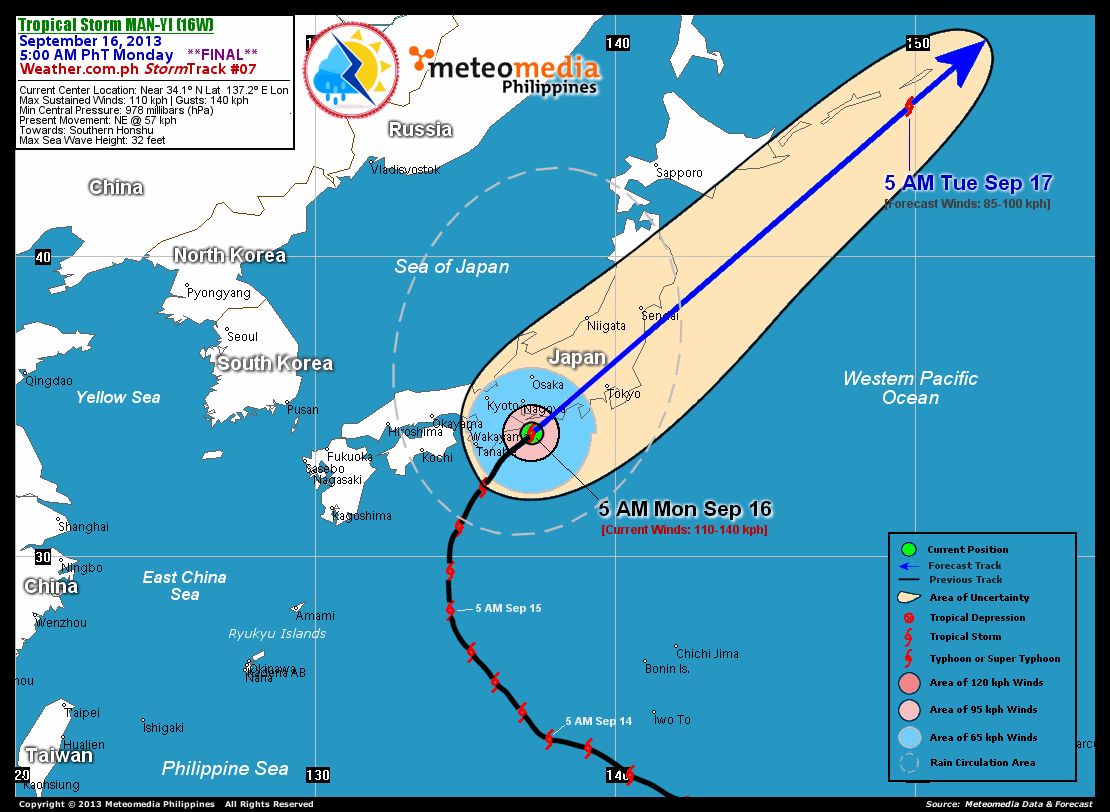
As of 5:00 am today, the center of TS Man-yi (16W) was located very near the coast of Mie, Aichi and Shizuoka Prefectures...about 125 km south-southeast of Nagoya, Japan or 290 km southwest of Tokyo, Japan...currently moving northeast with an increased forward speed of 57 km/hr towards Southern Honshu, Japan and Kuril Islands.
Maximum Sustained Winds (1-min. avg) have increased to 110 km/hr near the center with higher gusts. Tropical Storm Force Winds (63-100 km/hr) extend outward up to 240 kilometers from the center. Man-yi (16W) remains a very large-sized tropical cyclone with a diameter of 1,110 kilometers across. The 24-hour rainfall accumulation near the center of Man-yi is estimated to be heavy (130 mm).
1-DAY FORECAST OUTLOOK*
TS Man-yi (16W) is expected to continue moving very rapidly northeastward during the next 12 to 24 hours. On the forecast track, the core of Man-Yi will make landfall over Aichi and Shizuoka Prefectures in Honshu, Japan this morning and move quickly across Yamanashi, Kanagawa, Saitama, Ibaraki, and Tochigi Prefectures before noon through the early afternoon. The system will exit the northeast coast of Honshu late this afternoon and will be along the Kuril Island Chain on Tuesday morning.
TS Man-yi will start to weaken during the next 12 to 24 hours...and will become Extratropical today. Advance Intensity Forecast (AIF) shows its 1-minute sustained winds decreasing to just 85 km/hr while over Kuril Islands on Tuesday.
The following is the summary of the 1-day forecast outlook on this system:
 TUESDAY MORNING: Becomes an Extratropical Cyclone as it weakens and moves across the Kuril Islands...about 705 km east-northeast of Sapporo, Japan [5AM SEP 17: 45.0N 149.8E @ 85kph].
*Please be reminded that the Forecast Outlook changes every 6 hours, and the Day 2 and 3 Forecast Tracks have an average error of 100 and 250 km respectively...while the wind speed forecast error, averages 35 kph per day. Therefore, a turn to the left or right of its future track and changes in its wind speed must be anticipated from time to time.
EFFECTS & HAZARDS SUMMARY
Below is the summary of the storm's parts and its hazards affecting specific areas. You can also view this image link for you to understand the parts.
CENTRAL DENSE OVERCAST (CDO) - where Near-Typhoon Conditions w/ Near-Typhoon Force Winds (100-140 kph) will be expected along the CDO (click here to know more about CDO). Possible "Eye" may also be forming underneath the cirrus canopy. Affected Areas: Coastal areas of Mie, Aichi and Shizuoka Prefectures. INNER RAINBANDS - where Tropical Storm Conditions with Tropical Storm Force Winds (63-99 kph) will be expected. Affected Areas: Southern Honshu OUTER RAINBANDS - where Tropical Depression Conditions with light, moderate to strong winds (30-62 kph) will be expected. Affected Areas: Central and Eastern Japan and the Southeastern part of the Sea of Japan (click here to know more about Rainbands). 24HR TOTAL RAINFALL ACCUMULATION - from 5 up to 49 mm (slight to moderate rainfall) can be expected along areas affected by the outer & inner rainbands (see above)...with isolated amounts of 50 to 130 mm (moderate to heavy) along areas to the north, northeast and near the center of Man-yi (16W).
Important Note: Please keep in mind that the above forecast outlook, effects and hazards summary changes every 6 to 12 hrs!
CURRENT TECHNICAL INFORMATION
Time/Date: 5:00 AM PhT Mon Sep 16, 2013
Class/Name: TS Man-yi (16W)
Location of Center: Near 34.1º N Lat 137.2º E Lon
Distance 1: 125 km SSE of Nagoya, Japan
Distance 2: 180 km ENE of Tanabe, Japan
Distance 3: 290 km SW of Tokyo, Japan
MaxWinds (1-min avg): 110 kph near the center
Peak Wind Gusts: 140 kph
Present Movement: NE @ 57 kph
Towards: Southern Honshu
24hr Rainfall Accum (Near the Center): Heavy [130 mm]
Minimum Central Pressure: 978 millibars (hPa)
Size (in Diameter): 1,110 km [Very Large]
Max Sea Wave Height (near center): 32 feet
T2K/WP StormTracks (for Public): GIF | Google Map (Flash)
CURRENT TRACKING MAP:
 _____________________________________________________________________________
__________________________________________________________________________________________________
CURRENT NOAA/MTSAT-2 INFRARED (IR) SATELLITE IMAGE:

__________________________________________________________________________________________________
>> To know the meteorological terminologies and acronyms used on this update visit the ff:
http://typhoon2000.ph/tcterm.htm
http://www.nhc.noaa.gov/aboutgloss.shtml
http://www.nhc.noaa.gov/acronyms.shtml
__________________________________________________________________________________________
For the complete details on TS MAN-YI (16W)...go visit our website @:
> http://www.typhoon2000.com
> http://www.maybagyo.com
<<<Typhoon2000.com Mobile >>>
Get the latest SMS Storm Alerts!
For more details: Text T2K TYPHOON to
2800 (Globe/TM) | Offline (Smart/TNT) | 2288 (Sun)
*Only P2.50 (Smart/Globe) / P2.00 (Sun) per msg received.
Click here on how to use this service (in PDF file)
Powered by: Synermaxx Corporation
Copyright © 2013 Typhoon2000.com All Rights Reserved
| Reply via web post | Reply to sender | Reply to group | Start a New Topic | Messages in this topic (1) |

No comments:
Post a Comment