
for Thursday, 25 March 2010 [6:39 PM PhT]


<<<Typhoon2000.com Mobile >>>
Get the latest 6-Hrly SMS Storm Alerts on AGATON!
For more details: Text T2K TYPHOON to
2800 (Globe/TM) | 216 (Smart/TNT) | 2288 (Sun)
*only P2.50 (Smart/Globe) / P2.00 (Sun) per msg received.
powered by: Synermaxx
Typhoon2000 (T2K) NEWS (Thu March 25 2010):
Currently issuing 6-hrly advisories (except 12 AM PhT) on TS OMAIS (AGATON).
OMAIS (AGATON) MAX WIND SPEED PER AGENCY:
+ USA (JTWC/1-min avg): 85 km/hr
+ Japan (JMA/10-min avg): 65 km/hr
+ Philippines (PAGASA/10-min avg): 65 km/hr
+ Korea (KMA/10-min avg): 65 km/hr
+ Hong Kong (HKO/10-min avg): 65 km/hr
+ Taiwan (CWB/10-min avg): 65 km/hr
+ Beijing (NMC/2-min avg): 65 kph
TROPICAL STORM OMAIS [AGATON/02W/1001]
T2K E-MAIL ADVISORY NUMBER 011
6:00 PM PhT (10:00 GMT) Thu 25 March 2010
Source: T2K Analysis/JTWC Warning #015
View: Advisory Archives (2004-2010)
Tropical Storm OMAIS (AGATON) has started decaying...losing wind strength to just 85 km/hr...drifting slowly Northward across the Philippine Sea. Meanwhile, a Cold Front has been spotted approaching Northern & Eastern Luzon...strong winds and occasional showers expected.
*Do not use this for life or death decision. This advisory is intended for additional information purposes only. Kindly refer to your country's official weather agency for local warnings, advisories & bulletins.
Current Storm Information
Time/Date: 6:00 PM PhT Thu Mar 25 2010
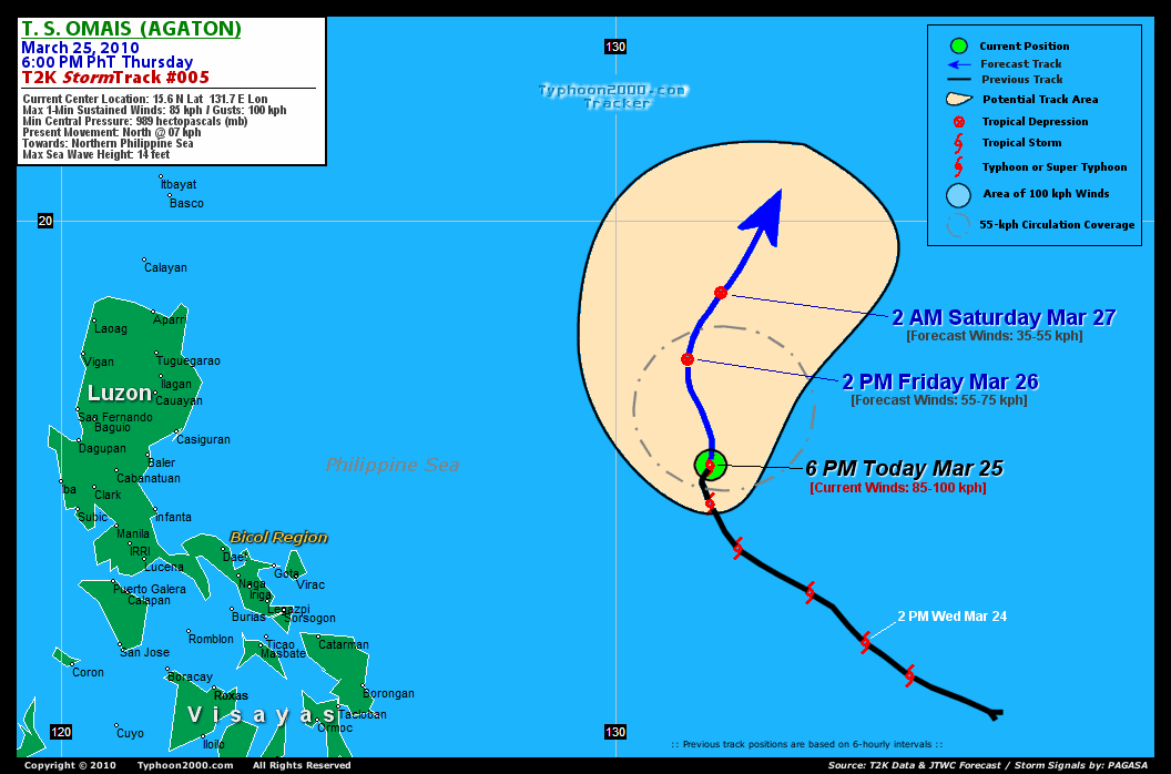
Location of Center: 15.6º N Lat 131.7º E Lon
Distance 1: 835 km (450 nm) ENE of Virac, Catanduanes
Distance 2: 875 km (472 nm) ENE of Gota, Caramoan
Distance 3: 940 km (507 nm) ENE of Metro Naga/CWC
Distance 4: 1,030 km (555 nm) ESE of Casiguran, Aurora
Distance 5: 1,155 km (625 nm) ENE of Metro Manila
MaxWinds (1-min avg): 85 kph (45 kts) near the center
Peak Wind Gusts: 100 kph (55 kts)
6-hr Rain Amounts (near the center): 150 mm [Moderate]
Minimum Central Pressure: 989 millibars (hPa)
Saffir-Simpson Typhoon Scale: TS
Present Movement: NNW @ 07 kph (04 kts)
Towards: Central Philippine Sea
Size (in Diameter): 295 km (160 nm) / Small
Max Sea Wave Height (near center): 14 ft (4.2 m)
Coastal Storm Surge Height: 0-3 feet [0-0.9 m]
T2K TrackMap #005 (for Public): 6 PM PhT Thu Mar 25
+ Forecast Outlook: OMAIS (AGATON) is expected to be downgraded into a Tropical Depression (TD) while moving slowly NNW-ward to Northward within the next 24 hours [2PM MAR 26: 17.5N 131.3E...about 1,020 km East of Tuguegarao City]. Increased upper-level winds (aka. Vertical Wind Shear) and lower Sea Surface Temperatures (SSTs) will continue to wrap into OMAIS' decaying circulation, letting it dissipate over the Northern Philippine Sea on early Saturday morning [2AM MAR 27: 18.7N 131.9E...about 1,055 ESE of Basco, Batanes]. There is also a possibility that the remnants of OMAIS, will be absorbed into the approaching Cold Front which is currently located off Taiwan. Please be reminded that the Forecast Outlook changes every 6 hours, so a turn to the left or right of its future track and other possibilities must be considered.
+ Effects & Hazards: OMAIS' rainbands remain over the ocean...no effects & hazards are in place. 6-hr total rainfall amounts of 5 up to 85 mm (light to moderate rain) can be expected along the its rainbands...with isolated amounts of up to 180 mm (heavy rain) situated along the northeastern periphery of OMAIS' (AGATON). Click here to view the latest NOAA's eTRaP graphic on the storm's rainfall amount.
+ Current NE Monsoon Intensity: LIGHT >> Sunny to mostly cloudy skies with passing showers & rains can be expected along the following affected areas: NORTHERN & EASTERN BICOL REGION & NORTHERN SAMAR. Light to moderate NE winds (not in excess of 40 kph) can be expected along these areas. Large ocean waves of up to 8 to 10 feet along the beach-front areas of the affected areas are likely to occur beginning tomorrow until Monday.
[Important Note: Please keep in mind that the above forecast outlook, effects, current monsoon intensity, & tropical cyclone watch changes every 6 to 12 hrs!]
External Links for TS OMAIS (AGATON)
View NOAA-CIRA's Latest Wind Analysis
JTWC Latest Tracking Chart: wp0210.gif
Multi-Agency Forecast TrackMap: 2 PM Thu Mar 25
TSR Wind Probabilities: Current to 36 hrs Ahead
Zoomed Satellite Pic: NOAA's Near Real-Time
Wunderground Animation: 6-12 hr. GIF Loop
JTWC (US NAVY / AIR FORCE) 12, 24, & 48 HR. FORECAST & REMARKS:
2 AM (18 GMT) 26 MARCH: 16.3N 131.2E / 75-95 KPH (TS) / N @ 11 KPH
2 PM (06 GMT) 26 MARCH: 17.5N 131.3E / 55-75 KPH (TD) / NNE @ 13 KPH
2 AM (18 GMT) 27 MARCH: 18.7N 131.9E / 35-55 KPH (LPA)
<<<Typhoon2000.
Get the latest 6-Hrly SMS Storm Alerts on AGATON!
For more details: Text T2K TYPHOON to
2800 (Globe/TM) | 216 (Smart/TNT) | 2288 (Sun)
*only P2.50 (Smart/Globe) / P2.00 (Sun) per msg received.
powered by: Synermaxx
Typhoon2000 (T2K) NEWS (Thu March 25 2010):
Currently issuing 6-hrly advisories (except 12 AM PhT) on TS OMAIS (AGATON).
OMAIS (AGATON) MAX WIND SPEED PER AGENCY:
+ USA (JTWC/1-min avg): 85 km/hr
+ Japan (JMA/10-min avg): 65 km/hr
+ Philippines (PAGASA/10-min avg): 65 km/hr
+ Korea (KMA/10-min avg): 65 km/hr
+ Hong Kong (HKO/10-min avg): 65 km/hr
+ Taiwan (CWB/10-min avg): 65 km/hr
+ Beijing (NMC/2-min avg): 65 kph
TROPICAL STORM OMAIS [AGATON/02W/
T2K E-MAIL ADVISORY NUMBER 011
6:00 PM PhT (10:00 GMT) Thu 25 March 2010
Source: T2K Analysis/JTWC Warning #015
View: Advisory Archives (2004-2010)
*Do not use this for life or death decision. This advisory is intended for additional information purposes only. Kindly refer to your country's official weather agency for local warnings, advisories & bulletins.
Current Storm Information
Time/Date: 6:00 PM PhT Thu Mar 25 2010
Location of Center: 15.6º N Lat 131.7º E Lon
Distance 1: 835 km (450 nm) ENE of Virac, Catanduanes
Distance 2: 875 km (472 nm) ENE of Gota, Caramoan
Distance 3: 940 km (507 nm) ENE of Metro Naga/CWC
Distance 4: 1,030 km (555 nm) ESE of Casiguran, Aurora
Distance 5: 1,155 km (625 nm) ENE of Metro Manila
MaxWinds (1-min avg): 85 kph (45 kts) near the center
Peak Wind Gusts: 100 kph (55 kts)
6-hr Rain Amounts (near the center): 150 mm [Moderate]
Minimum Central Pressure: 989 millibars (hPa)
Saffir-Simpson Typhoon Scale: TS
Present Movement: NNW @ 07 kph (04 kts)
Towards: Central Philippine Sea
Size (in Diameter): 295 km (160 nm) / Small
Max Sea Wave Height (near center): 14 ft (4.2 m)
Coastal Storm Surge Height: 0-3 feet [0-0.9 m]
T2K TrackMap #005 (for Public): 6 PM PhT Thu Mar 25
+ Forecast Outlook: OMAIS (AGATON) is expected to be downgraded into a Tropical Depression (TD) while moving slowly NNW-ward to Northward within the next 24 hours [2PM MAR 26: 17.5N 131.3E...about 1,020 km East of Tuguegarao City]. Increased upper-level winds (aka. Vertical Wind Shear) and lower Sea Surface Temperatures (SSTs) will continue to wrap into OMAIS' decaying circulation, letting it dissipate over the Northern Philippine Sea on early Saturday morning [2AM MAR 27: 18.7N 131.9E...about 1,055 ESE of Basco, Batanes]. There is also a possibility that the remnants of OMAIS, will be absorbed into the approaching Cold Front which is currently located off Taiwan. Please be reminded that the Forecast Outlook changes every 6 hours, so a turn to the left or right of its future track and other possibilities must be considered.
+ Effects & Hazards: OMAIS' rainbands remain over the ocean...no effects & hazards are in place. 6-hr total rainfall amounts of 5 up to 85 mm (light to moderate rain) can be expected along the its rainbands...
[Important Note: Please keep in mind that the above forecast outlook, effects, current monsoon intensity, & tropical cyclone watch changes every 6 to 12 hrs!]
External Links for TS OMAIS (AGATON)
View NOAA-CIRA's Latest Wind Analysis
JTWC Latest Tracking Chart: wp0210.gif
Multi-Agency Forecast TrackMap: 2 PM Thu Mar 25
TSR Wind Probabilities: Current to 36 hrs Ahead
Zoomed Satellite Pic: NOAA's Near Real-Time
Wunderground Animation: 6-12 hr. GIF Loop
2 AM (18 GMT) 26 MARCH: 16.3N 131.2E / 75-95 KPH (TS) / N @ 11 KPH
2 PM (06 GMT) 26 MARCH: 17.5N 131.3E / 55-75 KPH (TD) / NNE @ 13 KPH
2 AM (18 GMT) 27 MARCH: 18.7N 131.9E / 35-55 KPH (LPA)
REMARKS (for Meteorologists)
*THE LOW LEVEL CIRCULATION CENTER (LLCC) APPEARS TO BE BECOMING EXPOSED
TO THE SOUTHWEST OF THE CENTRAL CONVECTION, BUT IT IS DIFFICULT TO ASSESS
DUE TO CIRRUS OVERCAST AND FADING DAYLIGHT. NONETHELESS, A 250438Z AMSUB
MICROWAVE IMAGE CONFIRMS THAT THE LLCC IS LOCATED NEAR THE SOUTHWESTERN
QUADRANT OF THE CENTRAL CONVECTION, WHICH IS ALSO CONSISTENT WITH THE
UPPER LEVEL PATTERN. VERTICAL WIND SHEAR HAS BEGUN TO ELEVATE ON THE
NORTH SIDE OF THE CIRCULATION AND IS EXPECTED TO GRADUALLY WEAKEN THE
SYSTEM OVER THE NEXT 36 HOURS AS AN UPPER LEVEL TROUGH ADVANCES
DOWNSTREAM. THE INITIAL FORECAST INTENSITY IS C0NSISTENT WITH DVORAK
INTENSITY ESTIMATES FROM PGTW AND RJTD RANGING FROM 35 TO 55 KNOTS.
THE TS WILL TEND TO TRACK POLEWARD WITH THE TROUGH AS IT PUSHES
DOWNSTREAM, BUT EXCESSIVE VERTICAL WIND SHEAR WILL LIKELY WEAKEN
THE SYSTEM BEFORE ENTRANCE INTO THE MID-LATITUDES. THE MODEL CONSENSUS
CONTINUES TO DEPICT A MORE AGGRESSIVE RECURVATURE, AS A RESULT, THE
FORECAST IS SLOWER THAN AND TO THE WEST OF CONSENSUS, ACCOUNTING FOR
DISSIPATION PRIOR TO RECURVATURE.
>> OMAIS, meaning: Palauan word for "wandering around". Name contributed by: United States of America.
____________
PAGASA CURRENT POSITION, MOVEMENT AND INTENSITY (10-min. ave.):
> 2 PM (06 GMT) THU 25 MARCH: 15.3N 132.3E / NNE @ 11 kph / 65 kph
:: For the complete PAGASA bulletin, kindly visit their website at:
http://www.pagasa.dost.gov.ph/wb/tcupdate.shtml
_______________________________________________________________________________________________________________________________________
:: For the complete PAGASA bulletin, kindly visit their website at:
http://www.pagasa.
____________
RECENT TYPHOON2000.
________________________
RECENT MTSAT-1R "DAY & NIGHT VISION" SATELLITE IMAGE:

> Image source: NOAA SATELLITE CENTER
RECENT WUNDERGROUND SATELLITE ANIMATION:

> Image source: Wunderground.com (http://www.wunderground.com/ ) ____________________________________________________________________________________________________________________
> Image source: NOAA SATELLITE CENTER
____________________________________________________________________________________________________________________
RECENT WUNDERGROUND SATELLITE ANIMATION:
> Image source: Wunderground.
LATEST 6 HR. TOTAL RAINFALL AMOUNTS / ENSEMBLE TROPICAL RAINFALL POTENTIAL (eTRaP):

> Image source: NOAA Satellite & Information Service (http://www.ssd.noaa.gov/PS/TROP/etrap.html )____________________________________________________________________________________________________________________
> Image source: NOAA Satellite & Information Service (http://www.ssd.
NOTE:
* - JTWC commentary remarks (for Meteorologists) from their latest warning.
__________________________________________________________________________________________
>> To know the meteorological terminologies and acronyms used on this update visit the ff:
http://typhoon2000.ph/tcterm.htm
http://www.nhc.noaa.gov/aboutgloss.shtml
http://www.srh.noaa.gov/oun/severewx/glossary.php
http://www.srh.weather.gov/fwd/glossarynation.html
http://www.nhc.noaa.gov/acronyms.shtml
__________________________________________________________________________________________
For the complete details on TS 02W (AGATON)...go visit our website @:
> http://www.typhoon2000.com
> http://www.maybagyo.com
>> To know the meteorological terminologies and acronyms used on this update visit the ff:
http://typhoon2000.
http://www.nhc.
http://www.srh.
http://www.srh.
http://www.nhc.
____________
> http://www.typhoon2
> http://www.maybagyo
Copyright © 2010 Typhoon2000.
__._,_.___
.
__,_._,___

No comments:
Post a Comment