
for Thursday, 25 March 2010 [12:19 PM PhT]


<<<Typhoon2000.com Mobile >>>
Get the latest 6-Hrly SMS Storm Alerts on AGATON!
For more details: Text T2K TYPHOON to
2800 (Globe/TM) | 216 (Smart/TNT) | 2288 (Sun)
*only P2.50 (Smart/Globe) / P2.00 (Sun) per msg received.
powered by: Synermaxx
Typhoon2000 (T2K) NEWS (Thu March 25 2010):
Currently issuing 6-hrly advisories (except 12 AM PhT) on TS OMAIS (AGATON).
OMAIS (AGATON) MAX WIND SPEED PER AGENCY:
+ USA (JTWC/1-min avg): 95 km/hr
+ Japan (JMA/10-min avg): 65 km/hr
+ Philippines (PAGASA/10-min avg): 65 km/hr
+ Korea (KMA/10-min avg): 65 km/hr
+ Hong Kong (HKO/10-min avg): 65 km/hr
+ Taiwan (CWB/10-min avg): 65 km/hr
+ Beijing (NMC/2-min avg): 65 kph
TROPICAL STORM OMAIS [AGATON/02W/1001]
T2K E-MAIL ADVISORY NUMBER 010
12:00 PM PhT (04:00 GMT) Thu 25 March 2010
Source: T2K Analysis/JTWC Warning #014
View: Advisory Archives (2004-2010)
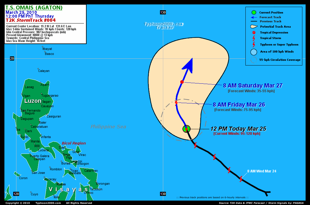
Tropical Storm OMAIS (AGATON) has already reached its peak strength and is now showing signs of decaying...continues on its NNW track across the Central Philippine Sea.
*Do not use this for life or death decision. This advisory is intended for additional information purposes only. Kindly refer to your country's official weather agency for local warnings, advisories & bulletins.
Current Storm Information
Time/Date: 12:00 PM PhT Thu Mar 25 2010
Location of Center: 15.2º N Lat 131.6º E Lon
Distance 1: 815 km (440 nm) ENE of Virac, Catanduanes
Distance 2: 855 km (462 nm) ENE of Gota, Caramoan
Distance 3: 920 km (497 nm) ENE of Metro Naga/CWC
Distance 4: 1,025 km (553 nm) ESE of Casiguran, Aurora
Distance 5: 1,140 km (615 nm) ENE of Metro Manila
MaxWinds (1-min avg): 95 kph (50 kts) near the center
Peak Wind Gusts: 120 kph (55 kts)
6-hr Rain Amounts (near the center): 180 mm [Heavy]
Minimum Central Pressure: 987 millibars (hPa)
Saffir-Simpson Typhoon Scale: TS
Present Movement: NNW @ 13 kph (07 kts)
Towards: Central Philippine Sea
Size (in Diameter): 295 km (160 nm) / Small
Max Sea Wave Height (near center): 16 ft (4.8 m)
Coastal Storm Surge Height: 0-3 feet [0-0.9 m]
T2K TrackMap #004 (for Public): 12 PM PhT Thu Mar 25
+ Forecast Outlook: OMAIS (AGATON) is expected to start weakening while moving NNW-ward within the next 12 hours, then turning Northward by tomorrow morning [8AM MAR 26: 17.0N 130.9E...about 800 km NE of Virac, Catanduanes]. The 2-day Short-Range Forecast shows OMAIS executing a recurvature towards the NNE beginning Friday evening as it rapidly dissipates along the Northern Philippine Sea [8AM MAR 27: 18.4N 131.3E...about 1,015 km East of Aparri, Cagayan]. Majority of the Global Forecast Guidance Models agree on this scenario. Please be reminded that the Forecast Outlook changes every 6 hours, so a turn to the left or right of its future track and other possibilities must be considered.
+ Effects & Hazards: OMAIS' rainbands remain over the ocean...no effects & hazards are in place. 6-hr total rainfall amounts of 5 up to 100 mm (light to moderate rain) can be expected along the outer and inner bands...with isolated amounts of up to 180 mm (heavy rain) near the center of OMAIS (AGATON). Click here to view the latest NOAA's eTRaP graphic on the storm's rainfall amount.
+ Current NE Monsoon Intensity: LIGHT >> Sunny to mostly cloudy skies with passing showers & rains can be expected along the following affected areas: NORTHERN & EASTERN BICOL REGION & NORTHERN SAMAR. Light to moderate NE winds (not in excess of 40 kph) can be expected along these areas. Large ocean waves of up to 8 to 10 feet along the beach-front areas of the affected areas are likely to occur beginning tomorrow until Monday.
[Important Note: Please keep in mind that the above forecast outlook, effects, current monsoon intensity, & tropical cyclone watch changes every 6 to 12 hrs!]
External Links for TS OMAIS (AGATON)
View NOAA-CIRA's Latest Wind Analysis
JTWC Latest Tracking Chart: wp0210.gif
Multi-Agency Forecast TrackMap: 8 AM Thu Mar 25
TSR Wind Probabilities: Current to 2-days Ahead
Zoomed Satellite Pic: NOAA's Near Real-Time
Wunderground Animation: 6-12 hr. GIF Loop
JTWC (US NAVY / AIR FORCE) 12, 24, & 48 HR. FORECAST & REMARKS:
8 PM (12 GMT) 25 MARCH: 16.1N 131.0E / 85-100 KPH (TS) / N @ 09 KPH
8 AM (00 GMT) 26 MARCH: 17.0N 130.9E / 75-95 KPH (TS) / N @ 07 KPH
8 AM (00 GMT) 27 MARCH: 18.4N 131.3E / 35-55 KPH (LPA)
<<<Typhoon2000.
Get the latest 6-Hrly SMS Storm Alerts on AGATON!
For more details: Text T2K TYPHOON to
2800 (Globe/TM) | 216 (Smart/TNT) | 2288 (Sun)
*only P2.50 (Smart/Globe) / P2.00 (Sun) per msg received.
powered by: Synermaxx
Typhoon2000 (T2K) NEWS (Thu March 25 2010):
Currently issuing 6-hrly advisories (except 12 AM PhT) on TS OMAIS (AGATON).
OMAIS (AGATON) MAX WIND SPEED PER AGENCY:
+ USA (JTWC/1-min avg): 95 km/hr
+ Japan (JMA/10-min avg): 65 km/hr
+ Philippines (PAGASA/10-min avg): 65 km/hr
+ Korea (KMA/10-min avg): 65 km/hr
+ Hong Kong (HKO/10-min avg): 65 km/hr
+ Taiwan (CWB/10-min avg): 65 km/hr
+ Beijing (NMC/2-min avg): 65 kph
TROPICAL STORM OMAIS [AGATON/02W/
T2K E-MAIL ADVISORY NUMBER 010
12:00 PM PhT (04:00 GMT) Thu 25 March 2010
Source: T2K Analysis/JTWC Warning #014
View: Advisory Archives (2004-2010)
*Do not use this for life or death decision. This advisory is intended for additional information purposes only. Kindly refer to your country's official weather agency for local warnings, advisories & bulletins.
Time/Date: 12:00 PM PhT Thu Mar 25 2010
Location of Center: 15.2º N Lat 131.6º E Lon
Distance 1: 815 km (440 nm) ENE of Virac, Catanduanes
Distance 2: 855 km (462 nm) ENE of Gota, Caramoan
Distance 3: 920 km (497 nm) ENE of Metro Naga/CWC
Distance 4: 1,025 km (553 nm) ESE of Casiguran, Aurora
Distance 5: 1,140 km (615 nm) ENE of Metro Manila
MaxWinds (1-min avg): 95 kph (50 kts) near the center
Peak Wind Gusts: 120 kph (55 kts)
6-hr Rain Amounts (near the center): 180 mm [Heavy]
Minimum Central Pressure: 987 millibars (hPa)
Saffir-Simpson Typhoon Scale: TS
Present Movement: NNW @ 13 kph (07 kts)
Towards: Central Philippine Sea
Size (in Diameter): 295 km (160 nm) / Small
Max Sea Wave Height (near center): 16 ft (4.8 m)
Coastal Storm Surge Height: 0-3 feet [0-0.9 m]
T2K TrackMap #004 (for Public): 12 PM PhT Thu Mar 25
+ Forecast Outlook: OMAIS (AGATON) is expected to start weakening while moving NNW-ward within the next 12 hours, then turning Northward by tomorrow morning [8AM MAR 26: 17.0N 130.9E...about 800 km NE of Virac, Catanduanes]
+ Current NE Monsoon Intensity: LIGHT >> Sunny to mostly cloudy skies with passing showers & rains can be expected along the following affected areas: NORTHERN & EASTERN BICOL REGION & NORTHERN SAMAR. Light to moderate NE winds (not in excess of 40 kph) can be expected along these areas. Large ocean waves of up to 8 to 10 feet along the beach-front areas of the affected areas are likely to occur beginning tomorrow until Monday.
[Important Note: Please keep in mind that the above forecast outlook, effects, current monsoon intensity, & tropical cyclone watch changes every 6 to 12 hrs!]
External Links for TS OMAIS (AGATON)
View NOAA-CIRA's Latest Wind Analysis
JTWC Latest Tracking Chart: wp0210.gif
Multi-Agency Forecast TrackMap: 8 AM Thu Mar 25
TSR Wind Probabilities: Current to 2-days Ahead
Zoomed Satellite Pic: NOAA's Near Real-Time
Wunderground Animation: 6-12 hr. GIF Loop
8 PM (12 GMT) 25 MARCH: 16.1N 131.0E / 85-100 KPH (TS) / N @ 09 KPH
8 AM (00 GMT) 26 MARCH: 17.0N 130.9E / 75-95 KPH (TS) / N @ 07 KPH
8 AM (00 GMT) 27 MARCH: 18.4N 131.3E / 35-55 KPH (LPA)
REMARKS (for Meteorologists)
*TROPICAL STORM (TS) 02W (OMAIS), LOCATED APPROXIMATELY 480 NM
NORTH-NORTHWEST OF PALAU, SHOWED CONSOLIDATED CONVECTION DURING THE
FIRST HALF OF THE PERIOD, HOWEVER, RECENT ANIMATED MULTISPECTRAL
SATELLITE IMAGERY INDICATES THAT THE LLCC MAY HAVE STARTED TO
DECOUPLE FROM THE UPPER LEVELS OVER THE PAST 3 TO 4 HOURS.
THROUGHOUT THE PERIOD, TS 02W INTENSIFIED AS IT TRACKED WEST-
NORTHWESTWARD INTO A REGION OF LOWER VERTICAL WIND SHEAR (VWS) UNDER
THE SUBTROPICAL RIDGE (STR) AXIS WITH ENHANCED POLEWARD OUTFLOW
AHEAD OF A UPSTREAM MID-LATITUDE TROUGH. TS OMAIS HAS STARTED TO
TURN SLIGHTLY POLEWARD ALONG THE WESTERN PERIPHERY OF THE STR AND
THE CURRENT INTENSITY IS BASED ON DVORAK ESTIMATES FROM PGTW, KNES,
AND RJTD RANGING FROM 35 TO 55 KNOTS...(more)
>> OMAIS, meaning: Palauan word for "wandering around". Name contributed by: United States of America.
____________
____________
RECENT TYPHOON2000.
________________________
RECENT MTSAT-1R "DAY & NIGHT VISION" SATELLITE IMAGE:

> Image source: NOAA SATELLITE CENTER
RECENT WUNDERGROUND SATELLITE ANIMATION:

> Image source: Wunderground.com (http://www.wunderground.com/ ) ____________________________________________________________________________________________________________________
> Image source: NOAA SATELLITE CENTER
____________________________________________________________________________________________________________________
RECENT WUNDERGROUND SATELLITE ANIMATION:
> Image source: Wunderground.
LATEST 6 HR. TOTAL RAINFALL AMOUNTS / ENSEMBLE TROPICAL RAINFALL POTENTIAL (eTRaP):

> Image source: NOAA Satellite & Information Service (http://www.ssd.noaa.gov/PS/TROP/etrap.html )____________________________________________________________________________________________________________________
> Image source: NOAA Satellite & Information Service (http://www.ssd.
NOTE:
* - JTWC commentary remarks (for Meteorologists) from their latest warning.
__________________________________________________________________________________________
>> To know the meteorological terminologies and acronyms used on this update visit the ff:
http://typhoon2000.ph/tcterm.htm
http://www.nhc.noaa.gov/aboutgloss.shtml
http://www.srh.noaa.gov/oun/severewx/glossary.php
http://www.srh.weather.gov/fwd/glossarynation.html
http://www.nhc.noaa.gov/acronyms.shtml
__________________________________________________________________________________________
For the complete details on TS 02W (AGATON)...go visit our website @:
> http://www.typhoon2000.com
> http://www.maybagyo.com
>> To know the meteorological terminologies and acronyms used on this update visit the ff:
http://typhoon2000.
http://www.nhc.
http://www.srh.
http://www.srh.
http://www.nhc.
____________
> http://www.typhoon2
> http://www.maybagyo
Copyright © 2010 Typhoon2000.
__._,_.___
.
__,_._,___

No comments:
Post a Comment