
for Wednesday, 24 March 2010 [1:13 PM PhT]


<<<Typhoon2000.com Mobile >>>
Get the latest SMS Storm Alerts!
For more details: Text T2K HELP to
2800 (Globe/TM) | 216 (Smart/TNT) | 2288 (Sun)
*only P2.50 (Smart/Globe) / P2.00 (Sun) per msg received.
powered by: Synermaxx
Typhoon2000 (T2K) NEWS (Wed March 24 2010):
Currently issuing 6-hrly advisories (except 12 AM PhT) on TS 02W (AGATON).
02W (AGATON) MAX WIND SPEED PER AGENCY:
+ USA (JTWC/1-min avg): 65 km/hr
+ Japan (JMA/10-min avg): 55 km/hr
+ Philippines (PAGASA/10-min avg): 55 km/hr
TROPICAL STORM 02W [AGATON]
T2K E-MAIL ADVISORY NUMBER 007
12:00 PM PhT (04:00 GMT) Wed 24 March 2010
Source: T2K Analysis/JTWC Warning #010
View: Advisory Archives (2004-2010)
Tropical Storm 02W (AGATON) has entered the Philippine Area of Responsibility (PAR)...now moving into the Philippine Sea. Storm's circulation not looking healthy.
*Do not use this for life or death decision. This advisory is intended for additional information purposes only. Kindly refer to your country's official weather agency for local warnings, advisories & bulletins.
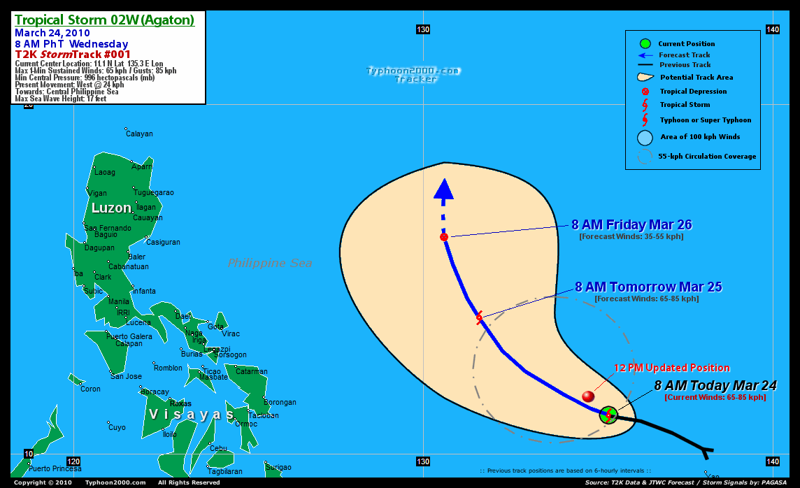
Current Storm Information
Time/Date: 12:00 PM PhT Wed Mar 24 2010
Location of Exposed Center: 11.7º N Lat 134.8º E Lon
Distance 1: 1,025 km (553 nm) East of Borongan, E.Samar
Distance 2: 1,160 km (625 nm) ESE of Virac, Catanduanes
Distance 3: 1,215 km (655 nm) ESE of Gota, Caramoan
Distance 4: 1,275 km (688 nm) ESE of Naga City
MaxWinds (1-min avg): 65 kph (35 kts) near the center
Peak Wind Gusts: 85 kph (45 kts)
6-hr Rain Amounts (near the center): 150 mm [Moderate]
Minimum Central Pressure: 996 millibars (hPa)
Saffir-Simpson Typhoon Scale: TS
Present Movement: West @ 24 kph (13 kts)
Towards: Central Philippine Sea
Size (in Diameter): 320 km (170 nm) / Small
Max Sea Wave Height (near center): 17 ft (5.1 m)
Coastal Storm Surge Height: 0-3 feet [0-0.9 m]
T2K TrackMap (for Public): 12 PM PhT Wed Mar 24
+ Forecast Outlook: 02W (AGATON) is expected to resume moving WNW to NW-ward within 24 hours and track across the central part of the Philippine Sea [8PM MAR 24: 12.4N 133.2E...8AM MAR 25: 13.9N 131.6E]. The 2-day Short-Range Forecast shows 02W turning NNW across the Philippine Sea as it weakens into a Tropical Depression (TD) tomorrow evening [8PM MAR 25: 15.3N 131.0E]...about 740 km ENE of Virac, Catanduanes. 02W (AGATON) will eventually dissipate into a Tropical Disturbance (LPA) on Friday morning [8AM MAR 26: 16.2N 130.6E...about 905 km East of Casiguran, Aurora] due to unfavorable atmospheric environment (eg. increased upper-level winds, cooler SST) affecting the system. Majority of Global Forecast Guidance Models agree on this scenario. Please be reminded that the Forecast Outlook changes every 6 hours, so a turn to the left or right of its future track and other possibilities must be considered.
+ Effects & Hazards: 02W's rainbands remains over the ocean...no effects & hazards are in place. 6-hr total rainfall amounts of 5 up to 90 mm (light to moderate rain) can be expected along the outer and inner bands...with isolated amounts of up to 150 mm (moderate rain) near the center of 02W. Click here to view the latest NOAA's eTRaP graphic on the storm's rainfall amount.
[Important Note: Please keep in mind that the above forecast outlook, effects, current monsoon intensity, & tropical cyclone watch changes every 6 to 12 hrs!]
External Links for TS 02W (AGATON)
View NOAA-CIRA's Latest Wind Analysis
JTWC Latest Tracking Chart: wp0210.gif
TSR Wind Probabilities: Current to 2-days Ahead
Zoomed Satellite Pic: NOAA's Near Real-Time
Wunderground Animation: 6-12 hr. GIF Loop
JTWC (US NAVY / AIR FORCE) 12, 24, & 48 HR. FORECAST & REMARKS:
8 PM (12 GMT) 24 MARCH: 12.4N 133.2E / 65-85 KPH (TS) / NW @ 20 KPH
8 AM (00 GMT) 25 MARCH: 13.9N 131.6E / 65-85 KPH (TS) / NNW @ 15 KPH
8 AM (00 GMT) 26 MARCH: 16.2N 130.6E / 35-55 KPH (LPA)
<<<Typhoon2000.
Get the latest SMS Storm Alerts!
For more details: Text T2K HELP to
2800 (Globe/TM) | 216 (Smart/TNT) | 2288 (Sun)
*only P2.50 (Smart/Globe) / P2.00 (Sun) per msg received.
powered by: Synermaxx
Typhoon2000 (T2K) NEWS (Wed March 24 2010):
Currently issuing 6-hrly advisories (except 12 AM PhT) on TS 02W (AGATON).
02W (AGATON) MAX WIND SPEED PER AGENCY:
+ USA (JTWC/1-min avg): 65 km/hr
+ Japan (JMA/10-min avg): 55 km/hr
+ Philippines (PAGASA/10-min avg): 55 km/hr
TROPICAL STORM 02W [AGATON]
T2K E-MAIL ADVISORY NUMBER 007
12:00 PM PhT (04:00 GMT) Wed 24 March 2010
Source: T2K Analysis/JTWC Warning #010
View: Advisory Archives (2004-2010)
*Do not use this for life or death decision. This advisory is intended for additional information purposes only. Kindly refer to your country's official weather agency for local warnings, advisories & bulletins.
Current Storm Information
Time/Date: 12:00 PM PhT Wed Mar 24 2010
Location of Exposed Center: 11.7º N Lat 134.8º E Lon
Distance 1: 1,025 km (553 nm) East of Borongan, E.Samar
Distance 2: 1,160 km (625 nm) ESE of Virac, Catanduanes
Distance 3: 1,215 km (655 nm) ESE of Gota, Caramoan
Distance 4: 1,275 km (688 nm) ESE of Naga City
MaxWinds (1-min avg): 65 kph (35 kts) near the center
Peak Wind Gusts: 85 kph (45 kts)
6-hr Rain Amounts (near the center): 150 mm [Moderate]
Minimum Central Pressure: 996 millibars (hPa)
Saffir-Simpson Typhoon Scale: TS
Present Movement: West @ 24 kph (13 kts)
Towards: Central Philippine Sea
Size (in Diameter): 320 km (170 nm) / Small
Max Sea Wave Height (near center): 17 ft (5.1 m)
Coastal Storm Surge Height: 0-3 feet [0-0.9 m]
T2K TrackMap (for Public): 12 PM PhT Wed Mar 24
+ Forecast Outlook: 02W (AGATON) is expected to resume moving WNW to NW-ward within 24 hours and track across the central part of the Philippine Sea [8PM MAR 24: 12.4N 133.2E...8AM MAR 25: 13.9N 131.6E]. The 2-day Short-Range Forecast shows 02W turning NNW across the Philippine Sea as it weakens into a Tropical Depression (TD) tomorrow evening [8PM MAR 25: 15.3N 131.0E]...about 740 km ENE of Virac, Catanduanes. 02W (AGATON) will eventually dissipate into a Tropical Disturbance (LPA) on Friday morning [8AM MAR 26: 16.2N 130.6E...about 905 km East of Casiguran, Aurora] due to unfavorable atmospheric environment (eg. increased upper-level winds, cooler SST) affecting the system. Majority of Global Forecast Guidance Models agree on this scenario. Please be reminded that the Forecast Outlook changes every 6 hours, so a turn to the left or right of its future track and other possibilities must be considered.
+ Effects & Hazards: 02W's rainbands remains over the ocean...no effects & hazards are in place. 6-hr total rainfall amounts of 5 up to 90 mm (light to moderate rain) can be expected along the outer and inner bands...with isolated amounts of up to 150 mm (moderate rain) near the center of 02W. Click here to view the latest NOAA's eTRaP graphic on the storm's rainfall amount.
[Important Note: Please keep in mind that the above forecast outlook, effects, current monsoon intensity, & tropical cyclone watch changes every 6 to 12 hrs!]
External Links for TS 02W (AGATON)
View NOAA-CIRA's Latest Wind Analysis
JTWC Latest Tracking Chart: wp0210.gif
TSR Wind Probabilities: Current to 2-days Ahead
Zoomed Satellite Pic: NOAA's Near Real-Time
Wunderground Animation: 6-12 hr. GIF Loop
8 PM (12 GMT) 24 MARCH: 12.4N 133.2E / 65-85 KPH (TS) / NW @ 20 KPH
8 AM (00 GMT) 25 MARCH: 13.9N 131.6E / 65-85 KPH (TS) / NNW @ 15 KPH
8 AM (00 GMT) 26 MARCH: 16.2N 130.6E / 35-55 KPH (LPA)
REMARKS (for Meteorologists)
*ANIMATED MULTISPECTRAL SATELLITE IMAGERY SHOWS THE LOW LEVEL
CIRCULATION CENTER (LLCC) HAS BECOME PARTIALLY-EXPOSED AND DECOUPLED
APPROXIMATELY 50 NM SOUTHEAST OF THE MAIN CONVECTION DUE TO MODERATE
EASTERLY VERTICAL WIND SHEAR (VWS) OVER THE PAST 12 HOURS. HOWEVER,
UPPER LEVEL ANALYSIS INDICATES THE SYSTEM IS LOCATED NEAR THE
SUBTROPICAL RIDGE AXIS AND CONTINUES TO HAVE STRONG RADIAL
OUTFLOW...(more)
____________
____________
RECENT TYPHOON2000.
________________________
RECENT MTSAT-1R "DAY & NIGHT VISION" SATELLITE IMAGE:

> Image source: NOAA SATELLITE CENTER
RECENT WUNDERGROUND SATELLITE ANIMATION:

> Image source: Wunderground.com (http://www.wunderground.com/ ) ____________________________________________________________________________________________________________________
> Image source: NOAA SATELLITE CENTER
____________________________________________________________________________________________________________________
RECENT WUNDERGROUND SATELLITE ANIMATION:
> Image source: Wunderground.
LATEST 6 HR. TOTAL RAINFALL AMOUNTS / ENSEMBLE TROPICAL RAINFALL POTENTIAL (eTRaP):

> Image source: NOAA Satellite & Information Service (http://www.ssd.noaa.gov/PS/TROP/etrap.html )____________________________________________________________________________________________________________________
> Image source: NOAA Satellite & Information Service (http://www.ssd.
NOTE:
* - JTWC commentary remarks (for Meteorologists) from their latest warning.
__________________________________________________________________________________________
>> To know the meteorological terminologies and acronyms used on this update visit the ff:
http://typhoon2000.ph/tcterm.htm
http://www.nhc.noaa.gov/aboutgloss.shtml
http://www.srh.noaa.gov/oun/severewx/glossary.php
http://www.srh.weather.gov/fwd/glossarynation.html
http://www.nhc.noaa.gov/acronyms.shtml
__________________________________________________________________________________________
For the complete details on TS 02W (AGATON)...go visit our website @:
> http://www.typhoon2000.com
> http://www.maybagyo.com
>> To know the meteorological terminologies and acronyms used on this update visit the ff:
http://typhoon2000.
http://www.nhc.
http://www.srh.
http://www.srh.
http://www.nhc.
____________
> http://www.typhoon2
> http://www.maybagyo
Copyright © 2010 Typhoon2000.
__._,_.___
.
__,_._,___

No comments:
Post a Comment