
for Thursday, 25 March 2010 [7:58 AM PhT]


<<<Typhoon2000.com Mobile >>>
Get the latest 6-Hrly SMS Storm Alerts on AGATON!
For more details: Text T2K TYPHOON to
2800 (Globe/TM) | 216 (Smart/TNT) | 2288 (Sun)
*only P2.50 (Smart/Globe) / P2.00 (Sun) per msg received.
powered by: Synermaxx
Typhoon2000 (T2K) NEWS (Thu March 25 2010):
Currently issuing 6-hrly advisories (except 12 AM PhT) on TS OMAIS (AGATON).
OMAIS (AGATON) MAX WIND SPEED PER AGENCY:
+ USA (JTWC/1-min avg): 95 km/hr
+ Japan (JMA/10-min avg): 65 km/hr
+ Philippines (PAGASA/10-min avg): 65 km/hr
+ Korea (KMA/10-min avg): 65 km/hr
+ Taiwan (CWB/10-min avg): 65 km/hr
+ Beijing (NMC/2-min avg): 65 kph
TROPICAL STORM OMAIS [AGATON/02W/1001]
T2K E-MAIL ADVISORY NUMBER 009
6:00 AM PhT (22:00 GMT) Thu 25 March 2010
Source: T2K Analysis/JTWC Warning #013
View: Advisory Archives (2004-2010)
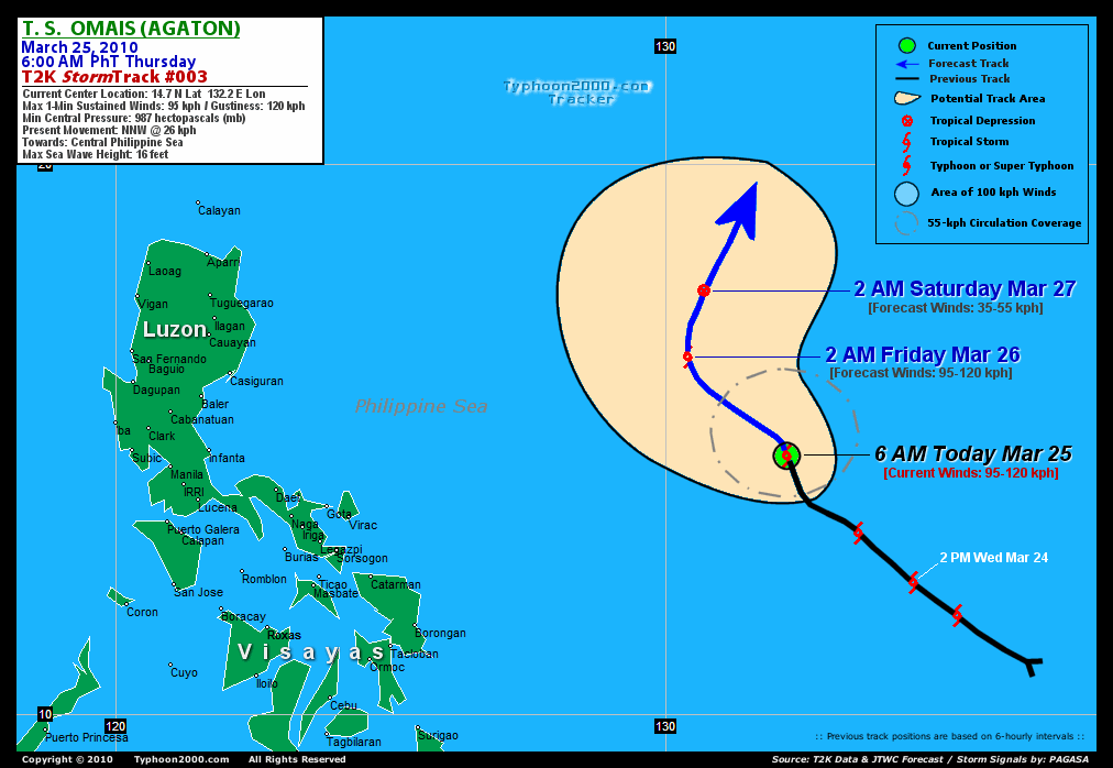
Tropical Storm OMAIS (AGATON) rapidly gained strength as it jogs to the NNW while over the Central Philippine Sea...Not a threat to the Philippines.
*Do not use this for life or death decision. This advisory is intended for additional information purposes only. Kindly refer to your country's official weather agency for local warnings, advisories & bulletins.
Current Storm Information
Time/Date: 6:00 AM PhT Thu Mar 25 2010
Location of Center: 14.7º N Lat 132.2º E Lon
Distance 1: 855 km (462 nm) ENE of Catarman, N.Samar
Distance 2: 870 km (470 nm) ENE of Virac, Catanduanes
Distance 3: 910 km (492 nm) ENE of Gota, Caramoan
Distance 4: 980 km (530 nm) ENE of Naga City
Distance 5: 1,205 km (650 nm) East of Metro Manila
MaxWinds (1-min avg): 95 kph (50 kts) near the center
Peak Wind Gusts: 120 kph (55 kts)
6-hr Rain Amounts (near the center): 180 mm [Heavy]
Minimum Central Pressure: 987 millibars (hPa)
Saffir-Simpson Typhoon Scale: TS
Present Movement: NNW @ 26 kph (14 kts)
Towards: Central Philippine Sea
Size (in Diameter): 295 km (160 nm) / Small
Max Sea Wave Height (near center): 16 ft (4.8 m)
Coastal Storm Surge Height: 0-3 feet [0-0.9 m]
T2K TrackMap #002 (for Public): 6 AM PhT Thu Mar 25
+ Forecast Outlook: OMAIS (AGATON) is expected to move NW to NNW-ward within the next 24 hours, across the central part of the Philippine Sea, reaching peak intensity of 100 kph this afternoon [2PM MAR 25: 15.4N 130.9E...about 750 km ENE of Virac, Catanduanes]. It will start losing strength, early tomorrow morning due to strong upper-level winds (Vertical Wind Shear) that will affect the storm [2AM MAR 26: 16.5N 130.4E]. The 2-day Short-Range Forecast shows OMAIS executing a recurvature towards the NNE on Friday as it rapidly dissipates [2AM MAR 27: 17.7N 130.7E...about 955 km East of Tuguegarao City]. Still, majority of the Global Forecast Guidance Models agree on this scenario. Please be reminded that the Forecast Outlook changes every 6 hours, so a turn to the left or right of its future track and other possibilities must be considered.
+ Effects & Hazards: OMAIS' rainbands remain over the ocean...no effects & hazards are in place. 6-hr total rainfall amounts of 5 up to 100 mm (light to moderate rain) can be expected along the outer and inner bands...with isolated amounts of up to 180 mm (heavy rain) near the center of OMAIS (AGATON). Click here to view the latest NOAA's eTRaP graphic on the storm's rainfall amount.
[Important Note: Please keep in mind that the above forecast outlook, effects, current monsoon intensity, & tropical cyclone watch changes every 6 to 12 hrs!]
External Links for TS OMAIS (AGATON)
View NOAA-CIRA's Latest Wind Analysis
JTWC Latest Tracking Chart: wp0210.gif
Multi-Agency Forecast TrackMap: 2 AM Thu Mar 25
TSR Wind Probabilities: Current to 2-days Ahead
Zoomed Satellite Pic: NOAA's Near Real-Time
Wunderground Animation: 6-12 hr. GIF Loop
JTWC (US NAVY / AIR FORCE) 12, 24, & 48 HR. FORECAST & REMARKS:
2 PM (06 GMT) 25 MARCH: 15.4N 130.9E / 100-130 KPH (TS) / NNW @ 11 KPH
2 AM (18 GMT) 26 MARCH: 16.5N 130.4E / 95-120 KPH (TS) / N @ 05 KPH
2 AM (18 GMT) 27 MARCH: 17.7N 130.7E / 35-55 KPH (LPA)
<<<Typhoon2000.
Get the latest 6-Hrly SMS Storm Alerts on AGATON!
For more details: Text T2K TYPHOON to
2800 (Globe/TM) | 216 (Smart/TNT) | 2288 (Sun)
*only P2.50 (Smart/Globe) / P2.00 (Sun) per msg received.
powered by: Synermaxx
Typhoon2000 (T2K) NEWS (Thu March 25 2010):
Currently issuing 6-hrly advisories (except 12 AM PhT) on TS OMAIS (AGATON).
OMAIS (AGATON) MAX WIND SPEED PER AGENCY:
+ USA (JTWC/1-min avg): 95 km/hr
+ Japan (JMA/10-min avg): 65 km/hr
+ Philippines (PAGASA/10-min avg): 65 km/hr
+ Korea (KMA/10-min avg): 65 km/hr
+ Taiwan (CWB/10-min avg): 65 km/hr
+ Beijing (NMC/2-min avg): 65 kph
TROPICAL STORM OMAIS [AGATON/02W/
T2K E-MAIL ADVISORY NUMBER 009
6:00 AM PhT (22:00 GMT) Thu 25 March 2010
Source: T2K Analysis/JTWC Warning #013
View: Advisory Archives (2004-2010)
*Do not use this for life or death decision. This advisory is intended for additional information purposes only. Kindly refer to your country's official weather agency for local warnings, advisories & bulletins.
Current Storm Information
Time/Date: 6:00 AM PhT Thu Mar 25 2010
Location of Center: 14.7º N Lat 132.2º E Lon
Distance 1: 855 km (462 nm) ENE of Catarman, N.Samar
Distance 2: 870 km (470 nm) ENE of Virac, Catanduanes
Distance 3: 910 km (492 nm) ENE of Gota, Caramoan
Distance 4: 980 km (530 nm) ENE of Naga City
Distance 5: 1,205 km (650 nm) East of Metro Manila
MaxWinds (1-min avg): 95 kph (50 kts) near the center
Peak Wind Gusts: 120 kph (55 kts)
6-hr Rain Amounts (near the center): 180 mm [Heavy]
Minimum Central Pressure: 987 millibars (hPa)
Saffir-Simpson Typhoon Scale: TS
Present Movement: NNW @ 26 kph (14 kts)
Towards: Central Philippine Sea
Size (in Diameter): 295 km (160 nm) / Small
Max Sea Wave Height (near center): 16 ft (4.8 m)
Coastal Storm Surge Height: 0-3 feet [0-0.9 m]
T2K TrackMap #002 (for Public): 6 AM PhT Thu Mar 25
+ Forecast Outlook: OMAIS (AGATON) is expected to move NW to NNW-ward within the next 24 hours, across the central part of the Philippine Sea, reaching peak intensity of 100 kph this afternoon [2PM MAR 25: 15.4N 130.9E...about 750 km ENE of Virac, Catanduanes]
[Important Note: Please keep in mind that the above forecast outlook, effects, current monsoon intensity, & tropical cyclone watch changes every 6 to 12 hrs!]
External Links for TS OMAIS (AGATON)
View NOAA-CIRA's Latest Wind Analysis
JTWC Latest Tracking Chart: wp0210.gif
Multi-Agency Forecast TrackMap: 2 AM Thu Mar 25
TSR Wind Probabilities: Current to 2-days Ahead
Zoomed Satellite Pic: NOAA's Near Real-Time
Wunderground Animation: 6-12 hr. GIF Loop
2 PM (06 GMT) 25 MARCH: 15.4N 130.9E / 100-130 KPH (TS) / NNW @ 11 KPH
2 AM (18 GMT) 26 MARCH: 16.5N 130.4E / 95-120 KPH (TS) / N @ 05 KPH
2 AM (18 GMT) 27 MARCH: 17.7N 130.7E / 35-55 KPH (LPA)
REMARKS (for Meteorologists)
*ANIMATED INFRARED SATELLITE
IMAGERY SHOWS CONSOLIDATING CONVECTION OVER THE LOW LEVEL
CIRCULATION CENTER (LLCC). THE CURRENT INTENSITY IS BASED
ON THE HIGHER END OF DVORAK ESTIMATES RANGING FROM 35 TO
55 KNOTS FROM PGTW, KNES, AND RJTD. UPPER LEVEL ANALYSIS
INDICATES THAT THE SYTEM IS CURRENTLY UNDER THE RIDGE AXIS
IN A REGION OF MODERATE VERTICAL WIND SHEAR (VWS) WITH
ENHANCED POLEWARD OUTFLOW DUE TO A PASSING MIDLATITUDE
TROUGH. TS OMAIS IS FORECAST TO INTENSIFY SLIGHTLY WHILE IT
REMAINS UNDER THE RIDGE AXIS BUT IS EXPECTED TO RAPIDLY
WEAKEN AS IT TRACKS WEST-NORTHWESTWARD INTO A REGION OF
INCREASED VWS AND CONVERGENCE ALOFT ASSOCIATED WITH AN
APPROACHING MIDLATITUDE TROUGH. BY TAU 48 TS 02W WILL DISSIPATE
OVER WATER AS A SIGNIFICANT TROPICAL CYCLONE. NUMERICAL MODEL
GUIDANCE IS IN GOOD AGREEMENT IN THE EARLY TAUS. IN THE LATER
TAUS, GFDN AND ECMWF SHOW THE SYSTEM TURNING SOUTHWESTWARD, WHILE
WBAR AND GFS SHOW THE SYSTEM BECOMING EXTRATROPICAL AND QUICKLY
MOVING OFF TO THE NORTHEAST...(more)
____________
____________
RECENT TYPHOON2000.
________________________
RECENT MTSAT-1R "DAY & NIGHT VISION" SATELLITE IMAGE:

> Image source: NOAA SATELLITE CENTER
RECENT WUNDERGROUND SATELLITE ANIMATION:

> Image source: Wunderground.com (http://www.wunderground.com/ ) ____________________________________________________________________________________________________________________
> Image source: NOAA SATELLITE CENTER
____________________________________________________________________________________________________________________
RECENT WUNDERGROUND SATELLITE ANIMATION:
> Image source: Wunderground.
LATEST 6 HR. TOTAL RAINFALL AMOUNTS / ENSEMBLE TROPICAL RAINFALL POTENTIAL (eTRaP):

> Image source: NOAA Satellite & Information Service (http://www.ssd.noaa.gov/PS/TROP/etrap.html )____________________________________________________________________________________________________________________
> Image source: NOAA Satellite & Information Service (http://www.ssd.
NOTE:
* - JTWC commentary remarks (for Meteorologists) from their latest warning.
__________________________________________________________________________________________
>> To know the meteorological terminologies and acronyms used on this update visit the ff:
http://typhoon2000.ph/tcterm.htm
http://www.nhc.noaa.gov/aboutgloss.shtml
http://www.srh.noaa.gov/oun/severewx/glossary.php
http://www.srh.weather.gov/fwd/glossarynation.html
http://www.nhc.noaa.gov/acronyms.shtml
__________________________________________________________________________________________
For the complete details on TS 02W (AGATON)...go visit our website @:
> http://www.typhoon2000.com
> http://www.maybagyo.com
>> To know the meteorological terminologies and acronyms used on this update visit the ff:
http://typhoon2000.
http://www.nhc.
http://www.srh.
http://www.srh.
http://www.nhc.
____________
> http://www.typhoon2
> http://www.maybagyo
Copyright © 2010 Typhoon2000.
__._,_.___
.
__,_._,___

No comments:
Post a Comment