Typhoon2000 STORM UPDATE #006
Name: TYPHOON NURI [KAREN/13W/0812]
Issued: 12:00 PM MANILA TIME (04:00 GMT) TUE 19 AUGUST 2008
Source: JTWC TROPICAL CYCLONE WARNING NUMBER 009
Note: Kindly refer to your country's official warnings or bulletins. This update is for additional information purposes only.
Source: JTWC TROPICAL CYCLONE WARNING NUMBER 009
Note: Kindly refer to your country's official warnings or bulletins. This update is for additional information purposes only.
_____________________________________________________________________________
TYPHOON NURI (KAREN) STILL INTENSIFYING AS IT RETURNS TO ITS WESTERLY
TRACK...ENDANGERS NORTHERN LUZON PARTICULARLY CAGAYAN, ISABELA AND
ILOCOS NORTE.
*This system may enhanced the SW Monsoon Rains across Southern Luzon & NW Visayas
today.
+ FORECAST OUTLOOK: NURI is expected to resume moving WNW for the next
*This system may enhanced the SW Monsoon Rains across Southern Luzon & NW Visayas
today.
+ FORECAST OUTLOOK: NURI is expected to resume moving WNW for the next
24 hours & shall cross the Northern Cagayan tomorrow morning at appro-
ximately 7-8 AM local time. The eye and its eyewall shall move across
the Calayan Group of Islands & pass just north of Ilocos Norte tomorrow
afternoon. The 2 to 5-day long-range forecast shows NURI gradually tur-
ning NW to NNW across the South China Sea on Thursday morning, Aug 21
and shall make its final landfall along the coast of Eastern Guangdong,
near Shantou City on Friday morning, Aug 22. NURI shall dissipated over
land along China on Sunday, Aug 24. *Alternate Forecast Scenario: There
is a slight possibilty that NURI may still turn NW earlier than expected,
hitting Batanes Area and into Southern Taiwan, if the High Pressure
Steering Ridge to its North weakens quickly.
+ EFFECTS: NURI's elongated circulation and spiral bands remains over
+ EFFECTS: NURI's elongated circulation and spiral bands remains over
the Philippine Sea. Its western-most outer rainbands is now spreading
across the eastern coast of Luzon. Passing light to moderate rains and
winds not exceeding 60 km/hr can be expected along these outer bands.
Residents in low-lying areas must seek higher grounds for possible floo-
ing & landslides due to the anticipated heavy rains brought about by
this disturbance. Precautionary measures must be initiated if necessary.
Possible coastal Storm Surge flooding of 4 to 5 feet above normal tide
levels...along with large and dangerous battering waves can be expected
near and to the north of NURI's projected path particularly when the
system moves over Extreme Northern Luzon. Minimal damage is possible on
this type of storm surge. Far-fetched storm surge is possible along
coastal areas of Eastern Luzon with surf reaching 3 feet at most.
+ CURRENT MONSOON TROUGH (ITCZ) INTENSITY: The Southwest (SW) Monsoon is
+ CURRENT MONSOON TROUGH (ITCZ) INTENSITY: The Southwest (SW) Monsoon is
now being enhanced slowly by TY NURI (KAREN) affecting Southern Luzon &
NW Visayas. This wind system is expected to bring mostly cloudy skies
with possible "on-&-off" light to moderate to sometimes heavy rains &
winds not exceeding 40 km/hr.
Important Note: Please keep in mind that the above forecast outlook,
effects & current monsoon intensity, and tropical cyclone watch changes
every 06 to 12 hours!
_____________________________________________________________________________
TIME/DATE: 11:00 AM MANILA TIME (03:00 GMT) 19 AUGUST
LOCATION OF EYE: LATITUDE 17.3º N...LONGITUDE 126.1º E
DISTANCE 1: 445 KM (240 NM) ENE OF CASIGURAN, AURORA, PH
effects & current monsoon intensity, and tropical cyclone watch changes
every 06 to 12 hours!
____________
LOCATION OF EYE: LATITUDE 17.3º N...LONGITUDE 126.1º E
DISTANCE 1: 445 KM (240 NM) ENE OF CASIGURAN, AURORA, PH
DISTANCE 2: 470 KM (255 NM) ESE OF TUGUEGARAO CITY, PH
DISTANCE 3: 480 KM (260 NM) ESE OF APARRI, CAGAYAN, PH
DISTANCE 3: 480 KM (260 NM) ESE OF APARRI, CAGAYAN, PH
DISTANCE 4: 560 KM (303 NM) SE OF BASCO, BATANES, PH
MAX WINDS [1-MIN AVG]: 150 KM/HR (80 KTS) NEAR THE CENTER
PEAK WIND GUSTS: 185 KM/HR (100 KTS)
SAFFIR-SIMPSON SCALE: CATEGORY ONE (1)
MINIMUM CENTRAL PRESSURE (est.): 963 MILLIBARS (hPa)
RECENT MOVEMENT: WEST @ 26 KM/HR (14 KTS)
GENERAL DIRECTION: CAGAYAN
STORM'S SIZE (IN DIAMETER): 610 KM (330 NM)/AVERAGE
MAX WAVE HEIGHT**: 18 FEET (5.4 METERS)
VIEW T2K TRACKING MAP: 11 AM MANILA TIME TUE AUGUST 19
TSR WIND PROBABILITIES: CURRENT TO 120 HRS LEAD
PHILIPPINE STORM SIGNALS*:
#03 - CAGAYAN AND ISABELA.
#02 - BATANES, BABUYAN, CALAYAN, APAYAO, KALINGA, MT. PROVINCE,
IFUGAO, QUIRINO, NORTHERN AURORA & NUEVA VIZCAYA.
#01 - ILOCOS PROVINCES, ABRA, BENGUET, LA UNION, PANGASINAN, NUEVA
ECIJA & REST OF AURORA.
12, 24, 48 & 72 HR. FORECAST:
8 PM (12 GMT) 19 AUGUST: 17.7N 124.1E / 165-205 KPH / WNW @ 19 KPH
IFUGAO, QUIRINO, NORTHERN AURORA & NUEVA VIZCAYA.
#01 - ILOCOS PROVINCES, ABRA, BENGUET, LA UNION, PANGASINAN, NUEVA
ECIJA & REST OF AURORA.
12, 24, 48 & 72 HR. FORECAST:
8 PM (12 GMT) 19 AUGUST: 17.7N 124.1E / 165-205 KPH / WNW @ 19 KPH
8 AM (00 GMT) 20 AUGUST: 18.3N 122.1E / 175-215 KPH / WNW @ 17 KPH
8 AM (00 GMT) 21 AUGUST: 20.3N 119.0E / 185-230 KPH / NW @ 13 KPH
8 AM (00 GMT) 22 AUGUST: 22.6N 117.1E / 195-240 KPH / NNW @ 11 KPH
REMARKS: 8 AM (00 GMT) 19 AUGUST POSITION: 17.1N 126.8E.
^TY NURI (13W) HAS STEADILY INTENSIFIED WHILE TRACKING GENERALLY
WESTWARD TOWARD LUZON OVER THE PAST 12 HOURS. HINTS OF A DEVELOPING
EYE ARE APPARENT IN BOTH MULTISPECTRAL AND WATER VAPOR SATELLITE
IMAGERY. SATELLITE WIND OBSERVATIONS AND ANIMATED WATER VAPOR IMAGERY
SHOW A WELL-DEVELOPED UPPER LEVEL ANTICYCLONE OVER THE SYSTEM, WITH
SYNOPTIC SCALE EASTERLY FLOW COMPRESSING THE STREAMLINES ON THE
EASTERN SIDE OF THE OUTFLOW LAYER. THE UPPER LEVEL ANTICYCLONE
ASSOCIATED WITH THE TYPHOON AND BROADER-SCALE EASTERLY FLOW ARE
ACTING IN TANDEM TO PROVIDE EXCELLENT WESTWARD AND EQUATORWARD
OUTFLOW. MODERATE POLEWARD OUTFLOW ALSO APPEARS TO BE DEVELOPING
TOWARD THE BASE OF A MID-LATITUDE TROUGH MIGRATING EASTWARD FROM
THE NORTHEASTERN CHINESE SEABOARD...(more)
>> NURI {pronounced: nu~ree}, meaning: Blue crowned parroquet in the
Malay language. Name contributed by: Malaysia.
_____________________________________________________________________________
PAGASA CURRENT POSITION, MOVEMENT AND INTENSITY (10-min. ave.):
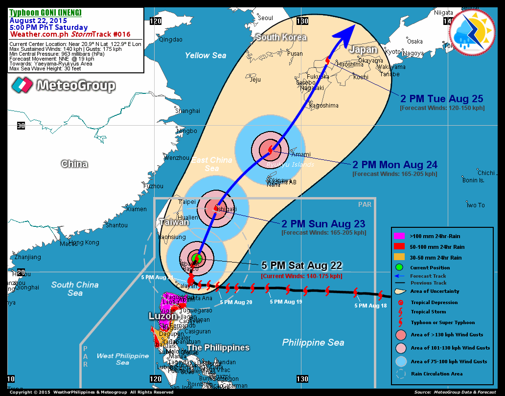
RECENT T2K TRACKING CHART:
8 AM (00 GMT) 22 AUGUST: 22.6N 117.1E / 195-240 KPH / NNW @ 11 KPH
REMARKS: 8 AM (00 GMT) 19 AUGUST POSITION: 17.1N 126.8E.
^TY NURI (13W) HAS STEADILY INTENSIFIED WHILE TRACKING GENERALLY
WESTWARD TOWARD LUZON OVER THE PAST 12 HOURS. HINTS OF A DEVELOPING
EYE ARE APPARENT IN BOTH MULTISPECTRAL AND WATER VAPOR SATELLITE
IMAGERY. SATELLITE WIND OBSERVATIONS AND ANIMATED WATER VAPOR IMAGERY
SHOW A WELL-DEVELOPED UPPER LEVEL ANTICYCLONE OVER THE SYSTEM, WITH
SYNOPTIC SCALE EASTERLY FLOW COMPRESSING THE STREAMLINES ON THE
EASTERN SIDE OF THE OUTFLOW LAYER. THE UPPER LEVEL ANTICYCLONE
ASSOCIATED WITH THE TYPHOON AND BROADER-SCALE EASTERLY FLOW ARE
ACTING IN TANDEM TO PROVIDE EXCELLENT WESTWARD AND EQUATORWARD
OUTFLOW. MODERATE POLEWARD OUTFLOW ALSO APPEARS TO BE DEVELOPING
TOWARD THE BASE OF A MID-LATITUDE TROUGH MIGRATING EASTWARD FROM
THE NORTHEASTERN CHINESE SEABOARD...(more)
>> NURI {pronounced: nu~ree}, meaning: Blue crowned parroquet in the
Malay language. Name contributed by: Malaysia.
____________
PAGASA CURRENT POSITION, MOVEMENT AND INTENSITY (10-min. ave.):
> 10 AM (02 GMT) 19 AUGUST: 17.2N 126.3E / WEST @ 22 KPH / 130 kph
:: For the complete PAGASA bulletin, kindly visit their website at:
http://www.pagasa.dost.gov.ph/wb/tcupdate.shtml
:: For the complete PAGASA bulletin, kindly visit their website at:
http://www.pagasa.
_____________________________________________________________________________
RECENT T2K TRACKING CHART:

________________________
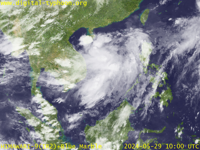
RECENT MTSAT-1R SATELLITE IMAGE:

> Image source: Digital-Typhoon.Org (http://www.digital-typhoon.org/ )
__________________________________________________________________________________________
NOTES:

> Image source: Digital-Typhoon.
^ - JTWC commentary remarks (for Meteorologists) from their
latest warning.
latest warning.
* - Based on PAGASA's Philippine Storm Warning Signals,
# 4 being the highest. For more explanations on these
signals, visit: http://www.typhoon2000.ph/signals.htm
** - Based on the Tropical Cyclone's Wave Height near
its center.
__________________________________________________________________________________________
>> To know the meteorological terminologies and acronyms
used on this update visit the ff:
http://typhoon2000.ph/tcterm.htm
http://www.nhc.noaa.gov/aboutgloss.shtml
http://www.srh.noaa.gov/oun/severewx/glossary.php
http://www.srh.weather.gov/fwd/glossarynation.html
http://www.nhc.noaa.gov/acronyms.shtml
__________________________________________________________________________________________
:: Typhoon2000.com (T2K) Mobile >> Powered by: Synermaxx
Receive the latest 6-hrly storm updates on KAREN directly to your mobile phones! To get:
Send T2K TYPHOON to: 2800 (GLOBE & TM) | 216 (SMART & TNT) | 2288 (SUN)
Note: Globe & Smart charges P2.50 per message, while Sun at P2.00.
__________________________________________________________________________________________
For the complete details on TY NURI (KAREN)...go visit
our website @:
> http://www.typhoon2000.com
> http://www.maybagyo.com
# 4 being the highest. For more explanations on these
signals, visit: http://www.typhoon2
** - Based on the Tropical Cyclone's Wave Height near
its center.
____________
>> To know the meteorological terminologies and acronyms
used on this update visit the ff:
http://typhoon2000.
http://www.nhc.
http://www.srh.
http://www.srh.
http://www.nhc.
____________
:: Typhoon2000.
Receive the latest 6-hrly storm updates on KAREN directly to your mobile phones! To get:
Send T2K TYPHOON to: 2800 (GLOBE & TM) | 216 (SMART & TNT) | 2288 (SUN)
Note: Globe & Smart charges P2.50 per message, while Sun at P2.00.
For the complete details on TY NURI (KAREN)...go visit
our website @:
> http://www.typhoon2
> http://www.maybagyo
Copyright © 2008 Typhoon2000.
Change settings via the Web (Yahoo! ID required)
Change settings via email: Switch delivery to Daily Digest | Switch format to Traditional
Visit Your Group | Yahoo! Groups Terms of Use | Unsubscribe
.
__,_._,___
No comments:
Post a Comment