
WEATHER.COM.PH TROPICAL CYCLONE UPDATES
TROPICAL DEPRESSION 02W (CRISING) UPDATE NUMBER 005
Issued: 7:00 PM PhT (11:00 GMT) Wednesday 20 Feb 2013
Next Update: 7:00 AM PhT (23:00 GMT) Thursday 21 Feb 2013
Tropical Depression 02W (Crising) has jogged northwestward across the Sulu Sea...moving closer to Southern Palawan. Its scattered rainbands continues to spread across Western Visayas and Palawan.
This depression will continue to enhance the Northeast Monsoon (Hanging Amihan) and bring cloudy skies w/ 15-60 km/hr winds across Northern Visayas and Luzon including Metro Manila...becoming occasionally slight to moderate rains along the regions of MIMAROPA, CALABARZON, Bicol & Eastern Visayas.
Do not use this for life or death decision. This update is intended for additional information purposes only. Kindly refer to your national weather agency for official warnings, advisories or bulletins.
CURRENT STORM ANALYSIS
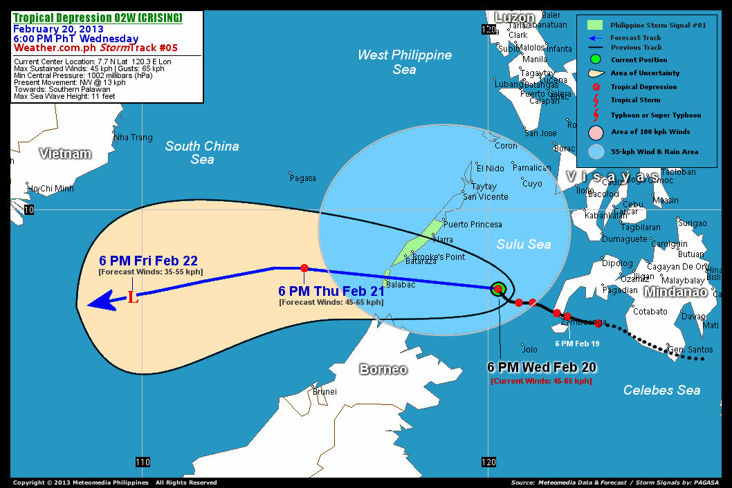
As of 6 pm today, the center of Tropical Depression 02W (Crising) was located over the Sulu Sea...about 218 km west-northwest of Zamboanga City or 317 km southeast of Bataraza, Palawan...currently moving northwest with a forward speed of 13 km/hr in the general direction of Southern Palawan.
Maximum Sustained Winds (1-min. avg) remains at 45 km/hr near the center with higher gusts. A WeatherPhilippines/Meteomedia Automated Weather Station (AWS) based in Dipolog City, Zamboanga Del Norte has recorded 152 millimeters (mm) of rainfall in a span of 24 hours, which is considered extreme or very heavy. The 24-hour rainfall accumulation near the center of 02W (Crising) is estimated to be heavy (250 mm).
2-DAY FORECAST OUTLOOK*
TD 02W (Crising) is expected to resume its westward track during the next 24 hours, with a turn to the west-southwest by 48 hours. On the forecast track, the core of 02W (Crising) will move across the Sulu Sea tonight...and will pass over the southern tip of Palawan by Thursday morning. This depression will move out of the Philippine Area of Responsibility (PAR) on Thursday evening...and could be just along the open waters of the South China Sea on Friday evening.
02W (Crising) is forecast to maintain its strength through the next 24 hours and will dissipate into an area of low pressure on Friday.
The following is the summary of the 2-day forecast outlook on this system:
 THURSDAY EVENING: Moving across the West Philippine Sea, exits the PAR...about 266 km west-northwest of Balabac, Palawan [6PM FEB 21: 8.3N 114.7E @ 45kph].
FRIDAY EVENING: Dissipates into an area of low pressure, as it moves across the southern part of the South China Sea...about 525 km south of Nha Trang City, Vietnam [6PM FEB 22: 7.5N 109.7E @ 35kph].
*Please be reminded that the Forecast Outlook changes every 6 hours, and the Day 3 Forecast Track have an average error of 250 km...while the wind speed forecast error, averages 35 kph per day. Therefore, a turn to the left or right of its future track and changes in its wind speed must be anticipated from time to time.
EFFECTS & HAZARDS SUMMARY
Below is the summary of the storm's parts and its hazards affecting specific areas. You can also view this image link for you to understand the parts.
RAINBANDS - spreading across Southwestern Philippines and Sulu Sea. Affected Areas: Western Visayas and Palawan. Tropical Disturbance Conditions with light, moderate to strong winds (05-55 kph) will be expected along these bands (click here to know more about Rainbands). 24HR TOTAL RAINFALL ACCUMULATION - from 5 up to 100 mm (slight to heavy rainfall) can be expected along areas affected by the rainbands (see above)...with isolated amounts of 101 to 250 mm (heavy) along areas to the north and near the center of 02W (Crising).
Important Note: Please keep in mind that the above forecast outlook, effects and hazards summary changes every 6 to 12 hrs!
CURRENT TECHNICAL INFORMATION
Time/Date: 6:00 PM PhT Wed February 20, 2013
Class/Name: TD 02W (Crising)
Location of Center: 7.7º N Lat 120.3º E Lon
Distance 1: 194 km NNW of Jolo, Sulu
Distance 2: 218 km WNW of Zamboanga City
Distance 3: 283 km SSE of Puerto Princesa
Distance 4: 317 km SE of Bataraza, Palawan
Distance 5: 354 km ESE of Balabac, Palawan
MaxWinds (1-min avg): 45 kph near the center
Peak Wind Gusts: 65 kph
Present Movement: NW @ 13 kph
Towards: Southern Palawan
24hr Rainfall Accum (near center): Heavy [250 mm]
Minimum Central Pressure: 1002 millibars (hPa)
Max Sea Wave Height (near center): 11 feet
Possible Storm Surge Height: 0 ft (0 m)
T2K/WP StormTracks (for Public): GIF | Google Map (Flash)

CURRENT NOAA/MTSAT-2 INFRARED SATELLITE IMAGE:

CURRENT TRACKING CHART:
_____________________________________________________________________________
>> To know the meteorological terminologies and acronyms used on this update visit the ff:
http://typhoon2000.ph/tcterm.htm
http://www.nhc.noaa.gov/aboutgloss.shtml
http://www.nhc.noaa.gov/acronyms.shtml
__________________________________________________________________________________________
For the complete details on TD 02W (CRISING)...go visit our website @:
> http://www.typhoon2000.com
> http://www.maybagyo.com
<<<Typhoon2000.com Mobile >>>
Get the latest SMS Storm Alerts!
For more details: Text T2K TYPHOON to
2800 (Globe/TM) | 216 (Smart/TNT) | 2288 (Sun)
*Only P2.50 (Smart/Globe) / P2.00 (Sun) per msg received.
Click here on how to use this service (in PDF file)
Powered by: Synermaxx Corporation
Copyright © 2012 Typhoon2000.com All Rights Reserved
| Reply via web post | Reply to sender | Reply to group | Start a New Topic | Messages in this topic (1) |

No comments:
Post a Comment