
Typhoon2000 (T2K) NEWS (Friday September 21, 2012):
Currently issuing 6-hrly web, email, SMS, & iTyphoon app updates (except 12 Midnight) on JELAWAT (LAWIN).
JELAWAT MAX WIND SPEED PER AGENCY:
+ USA (JTWC/1-min avg): 215 km/hr
+ Japan (JMA/10-min avg): 175 km/hr
+ Philippines (PAGASA/10-min avg): 175 km/hr
+ Beijing (NMC/2-min avg): 180 km/hr
+ Taiwan (CWB/10-min avg): 170 km/hr
+ Korea (KMA/10-min avg): 180 km/hr
+ Hong Kong (HKO/10-min avg): 175 km/hr
:: Click here to see Multi-Agency Forecast Tracks
TYPHOON2000 (T2K) TROPICAL CYCLONE UPDATES
TYPHOON JELAWAT (LAWIN) UPDATE NUMBER 25
6:00 PM PhT (10:00 GMT) Fri 28 September 2012
Sources: T2K Analysis/JTWC Warnings/Dynamic Models/SatFixes
View: T2K TC Update Archives (2004-2012)
Typhoon JELAWAT (LAWIN) continues to lose strength as it passes close to Ishigaki...now heading towards Okinawa and the Ryukyus. Typhoon Conditions will be expected along these areas.
Meanwhile, Tropical Storm EWINIAR (19W) located outside of the Philippine Area of Responsibility (PAR) has maintained its strength as it moves ENE. Its center was located about 515 km SE of Tokyo, Japan (32.3N 143.5E)...with 1-min. sustained winds of 85 kph near the center, moving ENE @ 15 kph towards the Northwest Pacific Ocean. Check out the latest details on this system by visiting this page.
Residents and visitors along Yaeyama-Ishigaki-Okinawa Islands and Japan should closely monitor the progress of Jelawat (Lawin).
Do not use this for life or death decision. This advisory is intended for additional information purposes only. Kindly refer to your country's official weather agency for local warnings, advisories & bulletins.
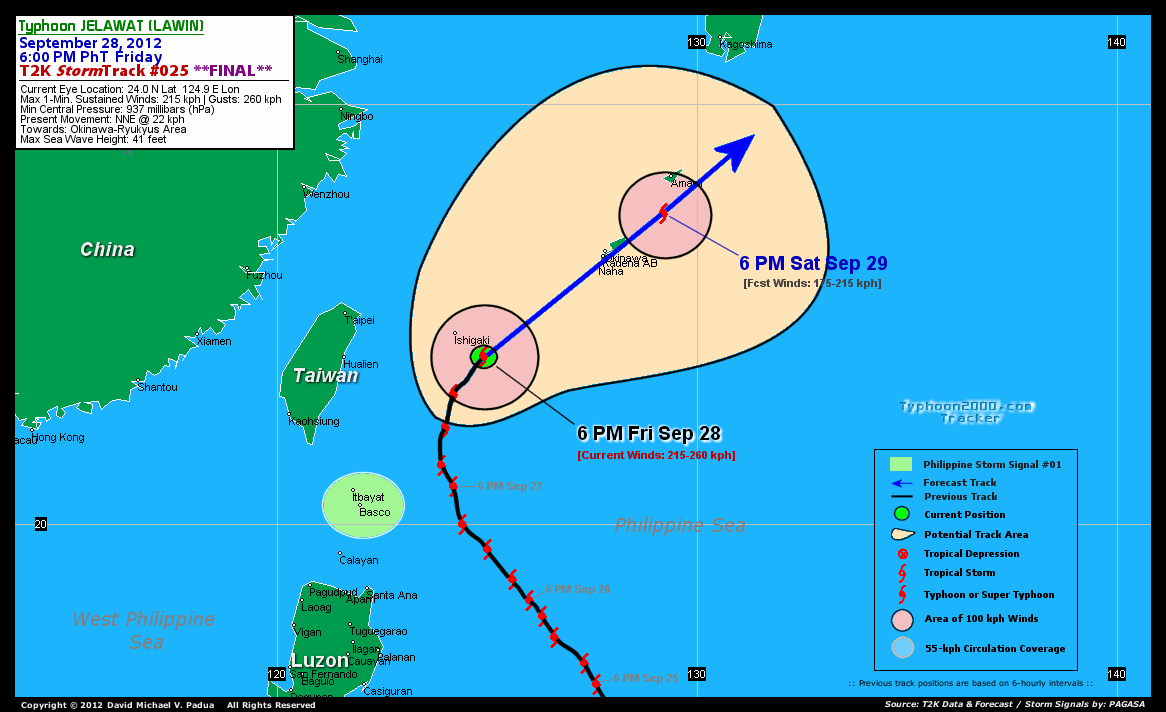
CURRENT STORM INFORMATION
Time/Date: 6:00 PM PhT Fri September 28, 2012
Location of Eye: 24.0º N Lat 124.9º E Lon
Distance 1: 63 km (SSE) away from Ishigaki Jima
Distance 2: 295 km (E) away from Hualien, Taiwan
Distance 3: 404 km (SW) closer to Naha International Airport
Distance 4: 426 km (SW) closer to Kadena Air Base
Distance 5: 433 km (SW) closer to Okinawa City
Distance 6: 466 km (NNE) away from Basco, Batanes
MaxWinds (1-min avg): 215 kph (115 kts) near the center
Peak Wind Gusts: 260 kph (140 kts)
Present Movement: NNE @ 22 kph (12 kts)
Towards: Okinawa-Ryukyus Area
CPA [ETA] to Okinawa: Saturday Noontime [approx 11AM-1PM JST]
NOAA 24hr Rainfall Accum (near center): 400 mm (VHigh)
Minimum Central Pressure: 937 millibars (hPa)
Saffir-Simpson Typhoon Scale: Category 4
Size (in Diameter): 1000 km (540 nm) [Very Large]
Wind Area Distribution (in Knots): Current Wind Profile
Max Sea Wave Height (near center): 41 ft
Possible Storm Surge Height: 13-18 ft (4-5.5 m)
T2K StormTracks (for Public): Google Map (Flash) | GIF (for Philippines only)
3-DAY FORECAST OUTLOOK & ANALYSIS*
JELAWAT (LAWIN) is expected to continue accelerating NNE to NE-ward during the rest of the forecast period. On the forecast track, the core of JELAWAT will pass over or very close to Okinawa around noontime tomorrow...and could make landfall over Southern Honshu late Sunday evening. By Monday afternoon, JELAWAT is likely to emerge over the Northwest Pacific Ocean after traversing Honshu while accelerating rapidly, northeastward.
Maximum Sustained Winds (1-min. avg) have decreased to 215 km/hr (115 knots) with higher gusts. This intense typhoon will continue to weaken during the next 3 days as it moves into an area of lower Ocean Heat Content (OHC) or cooler sea-surface temperatures.
Typhoon Force Winds (118 km/hr or more) extend outward up to 130 kilometers (70 nautical miles) from the center...and Tropical Storm Force Winds (62-117 km/hr) extend outward up to 305 kilometers (165 nautical miles). JELAWAT is a very large-sized tropical cyclone with a diameter of 1,000 kilometers (540 nautical miles) across.
The following is the summary of the 3-day forecast outlook on this system:
 SATURDAY EVENING: Accelerating rapidly northeastward...starts to move away from Okinawa...weakens to Category 2...about 102 km SSW of Amami Island [6PM SEP 29: 27.4N 129.2E @ 175kph].
SUNDAY EVENING: Just along the southern coast of Honshu (Japan)...weakens to Category 1 as it prepares to make landfall...about 101 km SE of Tanabe, Japan [6PM SEP 30: 33.0N 136.1E @ 140kph].
MONDAY EVENING: Becomes Extratropical as it starts to move away from Eastern Honshu across the Northwest Pacific Ocean...about 436 km ESE of Sapporo, Japan [6PM OCT 01: 41.9N 146.5E @ 95kph].
*Please be reminded that the Forecast Outlook changes every 6 hours, and the Day 3 Forecast Track have an average error of 250 km...while the wind speed forecast error, averages 35 kph per day. Therefore, a turn to the left or right of its future track and changes in its wind speed must be anticipated from time to time.
EFFECTS & HAZARDS SUMMARY
Below is the summary of the storm's parts and its hazards affecting specific areas. You can also view this image link for you to understand the parts.
48-KM CLOUD-FILLED EYE - over water (North Philippine Sea...may reach the Okinawa around noontime on Saturday. Possible calm and lull conditions (with <20 kph winds) will be expected inside the eye (click here to know more about the EYE). EYEWALL - over water (North Philippine Sea)...not yet affecting any land areas...but will reach and affect Okinawa by Saturday morning. Typhoon Conditions with Typhoon Force Winds (>118 kph) will be expected within this wall (click here to know more about the Eyewall). INNER RAINBANDS - affecting and spreading across Yaeyama and Ishigaki Jima...will reach Okinawa later tonight. Tropical Storm Conditions with Tropical Storm Force Winds (62-117 kph) will be expected along these bands. OUTER RAINBANDS - affecting and spreading across Okinawa, Ryukyu Islands, Rest of Taiwan, and Batanes. Cloudy/Rainy Conditions with moderate to strong winds (<62 kph) will be expected along these bands (click here to know more about Rainbands). 24HR TOTAL RAINFALL ACCUMULATION - from 5 up to 200 mm (low to high rainfall) can be expected along areas affected by the outer & inner rainbands (see above)...with isolated amounts of 201 to 400 mm (high to very high) along areas near the center of Jelawat (Lawin) (click to open NOAA's eTRaP graphic). COASTAL STORM SURGE FLOODING - possible 13-18 ft [4-5.5 m] above normal tide levels...accompanied by large and dangerous battering waves can be expected along the coastal, inland lakes and beach front areas of Yaeyama, Ishigaki Jima, and Okinawa tonight through Saturday. Extreme damage is likely on this type of storm surge. Danger from Rip Currents or Rip Tides can be expected along the rest of the beach-front areas of Extreme Northern and Eastern Luzon, and Eastern Taiwan (click here to know more about Storm Surge).
Important Note: Please keep in mind that the above forecast outlook, effects-hazards, current monsoon intensity, & tropical cyclone watch changes every 6 to 12 hrs!![]()
PAGASA Philippine Storm Warnings Signals
Kindly visit: The official PAGASA Website to view the Signals hoisted
External Links for TY JELAWAT (LAWIN)
PAGASA: Hourly Updates
View NOAA-CIRA's: Latest Full Wind Analysis
JTWC Latest Tracking Chart: wp1812.gif
Multi-Agency Forecast TrackMap: Near Real-Time
TSR Wind Probabilities: Current to 3 Days Ahead
JAXA TRMM Page: Latest Rainrate (in mm/hr)
NASA TRMM Page: Jelawat's Rainrate Archives (in mm/hr)
Zoomed Satellite Pic: NOAA's Near Real-Time
Wunderground Animation: 6-12 hr. GIF Loop

CURRENT NOAA/MTSAT-2 INFRARED (IR) SATELLITE IMAGE:

CURRENT TYPHOON2000.COM TRACKING MAP:
 _____________________________________________________________________________
>> To know the meteorological terminologies and acronyms used on this update visit the ff:
http://typhoon2000.ph/tcterm.htm
http://www.nhc.noaa.gov/aboutgloss.shtml
http://www.nhc.noaa.gov/acronyms.shtml
__________________________________________________________________________________________
For the complete details on TY JELAWAT (LAWIN)...go visit our website @:
> http://www.typhoon2000.com
> http://www.maybagyo.com
<<<Typhoon2000.com Mobile >>>
Get the latest SMS Storm Alerts!
For more details: Text T2K TYPHOON to
2800 (Globe/TM) | 216 (Smart/TNT) | 2288 (Sun)
*Only P2.50 (Smart/Globe) / P2.00 (Sun) per msg received.
Click here on how to use this service (in PDF file)
Powered by: Synermaxx Corporation
Copyright © 2012 Typhoon2000.com All Rights Reserved
| Reply via web post | Reply to sender | Reply to group | Start a New Topic | Messages in this topic (1) |

No comments:
Post a Comment