Tuesday, October 09, 2007

TS KROSA (INENG) - Final Update


Typhoon2000 STORM UPDATE #014 **FINAL**
Name: TROPICAL STORM KROSA [INENG/17W/0715] 
Issued: 7:00 PM MANILA TIME (11:00 GMT) MON 08 OCTOBER 2007
Source: JTWC TROPICAL CYCLONE WARNING NUMBER 028
Note: Kindly refer to your country's official warnings or bulletins. This update is for additional information purposes only.
_____________________________________________________________________________
 
 
TROPICAL STORM KROSA (INENG) DISSIPATING OFF ZHEJIANG PROVINCE...TO
MOVE BACK TO SEA TONIGHT.

..THIS IS THE FINAL UPDATE ON THIS SYSTEM.

+ FORECAST OUTLOOK: KROSA is expected to be downgraded into a Tropical
Depression later tonight and accelerate ENE back into the East China Sea
tomorrow afternoon. This system shall continue to lose strength as it
enters an area of unfavorable atmospheric environment (cooler waters
and increasing wind shear conditions). Complete dissipation of KROSA
is likely by tomorrow evening, Oct 9

+ EFFECTS: KROSA's inner rainbands remains over Zhejiang Province with
its outer rainbands spreading across the rest of Fujian and Zhejiang.
Gale Force winds with heavy torrential rains will prevail near its
center, while strong winds not exceeding 30 kph with intermittent
rainfall can be expected along its inner rainbands. Cloudy skies with
passing light to moderate and sometimes heavy downpour can be expected
along its outer bands.

+ CURRENT MONSOON INTENSITY: Southwest (SW) Monsoon
has considerably
dissipated over the South China Sea. Climatic pattern shows transition
phase into the Northeast Monsoon which shall start sometime this
November.
 
Important Note: Please keep in mind that the above forecast outlook,
effects & current monsoon intensity, and tropical cyclone watch changes 
every 06 to 12 hours!

_____________________________________________________________________________

TIME/DATE: 5:00 PM MANILA TIME (09:00 GMT) 08 OCTOBER
LOCATION OF CENTER: LATITUDE 27.9º N...LONGITUDE 120.4º E
DISTANCE 1: 30 KM (17
NM) SW OF WENZHOU, CHINA
MAX SUSTAINED WINDS [1-MIN AVG]: 65 KM/HR (35 KTS)
PEAK WIND GUSTS: 85 KM/HR (45 KTS)
SAFFIR-SIMPSON SCALE: N/A 
MINIMUM CENTRAL PRESSURE (est.): 996 MILLIBARS (hPa)
RECENT MOVEMENT: ENE @ 03 KM/HR (02 KTS)
GENERAL DIRECTION: ZHEJIANG PROVINCE
STORM'S SIZE (IN DIAMETER): 500 KM (270 NM)/AVERAGE
MAX WAVE HEIGHT**: 10 FEET (3.0 METERS)
VIEW TRACKING MAP: 2 PM MANILA TIME MON OCTOBER 08
TSR WIND PROBABILITIESCURRENT TO 36 HRS LEAD  
PHILIPPINE STORM SIGNALS*: N/A

12, 24 HR. FORECAST:
2 AM (18 GMT) 09 OCTOBER: 28.1N 120.9E / 55-75 KPH / ENE @ 09 KPH
2 PM (06 GMT) 09 OCTOBER: 28.5N 122.0E / 45-65 KPH / E @ 13 KPH

REMARKS: 2 PM (06 GMT) 08 OCTOBER POSITION: 27.8N 120.2E.
^TROPICAL STORM (TS) 17W (KROSA) HAS REMAINED QUASISTATIONARY
OVER LAND DURING THE LAST 12 HOURS. THE OVERALL MOTION HAS BEEN A
SLOW DRIFT NORTHWARD, BUT AT LESS THAN 2 KNOTS. DURING THIS TIME,
TS 17W WEAKENED TO A MINIMAL TROPICAL STORM AND HAS REMAINED OVER
LAND. TS 17W HAS MAINTAINED A WELL DEFINED LOW LEVEL CIRCULATION
CENTER (LLCC), DESPITE HAVING BEEN OVER LAND FOR THE PAST 24 HOURS.
RECENT ANIMATED ENHANCED INFRARED SATELLITE IMAGERY DEPICTS A
PARTIALLY TO FULLY EXPOSED LLCC WITH DIMINISHING DEEP
CONVECTION
...(more)

>> KROSA {pronounced: kro~saah}, meaning: Crane
   Name contributed by: Cambodia.

_____________________________________________________________________________
_____________________________________________________________________________

RECENT TRACKING CHART:


_______________________________________________________________________________________

 
RECENT MTSAT-1R SATELLITE IMAGE:


> Image source:  Digital-Typhoon.org (Nat'l. Institute of Informatics) (http://www.digital-typhoon.org)
__________________________________________________________________________________________

NOTES:
 
  ^ - JTWC commentary remarks (for Meteorologists) from their 
      latest warning.
 
  * - Based on PAGASA's Philippine Storm Warning Signals, 
      # 4 being the highest. Red letters indicate new areas 
      being hoisted.
For more explanations on these signals, 
      visit:
http://www.typhoon2000.ph/signals.htm

 ** - Based on the Tropical Cyclone's Wave Height near 
      its center.

__________________________________________________________________________________________

>>
To know the meteorological terminologies and acronyms 
   used on this update visit the ff:

    http://typhoon2000.ph/tcterm.htm  
    http://www.nhc.noaa.gov/aboutgloss.shtml
    http://www.srh.noaa.gov/oun/severewx/glossary.php
    http://www.srh.weather.gov/fwd/glossarynation.html
    http://www.nhc.noaa.gov/acronyms.shtml
__________________________________________________________________________________________

:: Typhoon2000.com (T2K) Mobile >> Powered by: Synermaxx
Receive the latest storm updates directly to your mobile phones! To know more:
Send T2K HELP to: 2800
(GLOBE & TM) | 216 (SMART & TNT) | 2288 (SUN) 
Note: Globe & Smart charges P2.50 per message, while Sun at P2.00.
__________________________________________________________________________________________

For the complete details on TS KROSA (INENG)...go visit
our website @:

>
http://www.typhoon2000.com
http://www.maybagyo.com

:: Kindly view our site's disclaimer at: 
   
http://www.typhoon2000.ph/disclaimer.htm


__._,_.___
Recent Activity
Visit Your Group
Green Groups

on Yahoo! Groups

share your passion

for the planet.

Endurance Zone

on Yahoo! Groups

Communities about

higher endurance.

Fashion Groups

on Yahoo! Groups

A great place to

connect and share.

.

__,_._,___

Monday, October 08, 2007

TS KROSA (INENG) lingering off Zhejiang...[Update #013]


Typhoon2000 STORM UPDATE #013
Name: TROPICAL STORM KROSA [INENG/17W/0715] 
Issued: 7:00 AM MANILA TIME (23:00 GMT) MON 08 OCTOBER 2007
Next Update: 7:00 PM (11:00 GMT) MON 08 OCTOBER
Source: JTWC TROPICAL CYCLONE WARNING NUMBER 026
Note: Kindly refer to your country's official warnings or bulletins. This update is for additional information purposes only.
_____________________________________________________________________________
 
 
TROPICAL STORM KROSA (INENG) HAS MADE LANDFALL OVER SOUTHEASTERN CHINA
...BARELY MOVING ALONG SOUTHERN ZHEJIANG...DISSIPATING BUT STILL QUITE
A PUNCH CARRYING WINDS OF 85 KM/HR.

+ FORECAST OUTLOOK: KROSA is expected to start moving slowly NE'ly to-
wards the Coast of Zhejiang Province within 24 hours and dissipate
further. Tomorrow morning, KROSA shall be downgraded to a Tropical
Depression upon moving back to the East China Sea on its way to Wes-
tern Japan. This weakening system shall continue to lose strength as
it enters an area of unfavorable atmospheric environment (cooler wa-
ters and increasing wind shear conditions). Complete dissipation of
KROSA shall be expected early Wednesday morning, Oct 10

+ EFFECTS: KROSA's weakening center is now over Zhejiang Province with
its inner rainbands spreading across the rest of Fujian and Zhejiang.
Gale Force to Tropical Storm winds with heavy torrential rains will
prevail near its center, while strong winds not exceeding 60 kph with
intermittent rainfall can be expected along its inner rainbands. Mean-
while, Krosa's outer rainbands continues to spread across Western Taiwan,
extending over other portions of SE and Southern China including Shanghai
area. Cloudy skies with passing light to moderate and sometimes heavy
downpour can be expected along its outer bands. Coastal Storm Surge floo-
ding of 1 to 2 feet above normal tide levels...along with large and dan-
gerous battering waves can be expected near and to the north of KROSA's
projected path particularly over SE China. Minimal damage is possible on
this type of storm surge. Far-fetched storm surge is possible along Wes-
tern Taiwan, Okinawa and Southern China. Flash floods and mudslides are
imminent along river banks, low-lying and mountainous regions of the
affected areas. Precautionary measures must be initiated especially
along the path of this storm.

+ CURRENT MONSOON INTENSITY: Southwest (SW) Monsoon
has considerably
dissipated over the South China Sea. Climatic pattern shows transition
phase into the Northeast Monsoon which shall start sometime this
November.

+ TROPICAL CYCLONE WATCH: A new developing Tropical Disturbance
(LPA/1008 MB) has spotted near Palau Island or about 1,215 km. ESE of
Surigao City (8.5N 136.5E)..moving West slowly. This disturbance will
be closely monitored for possible development and threat to the
Philippines this week. Stay tuned.
 
Important Note: Please keep in mind that the above forecast outlook,
effects & current monsoon intensity, and tropical cyclone watch changes 
every 06 to 12 hours!

_____________________________________________________________________________

TIME/DATE: 5:00 AM MANILA TIME (21:00 GMT) 08 OCTOBER
LOCATION OF CENTER: LATITUDE 27.8º N...LONGITUDE 120.1º E
DISTANCE 1: 55 KM (100
NM) WSW OF WENZHOU, CHINA
MAX SUSTAINED WINDS [1-MIN AVG]: 85 KM/HR (45 KTS)
PEAK WIND GUSTS: 100 KM/HR (55 KTS)
SAFFIR-SIMPSON SCALE: N/A 
MINIMUM CENTRAL PRESSURE (est.): 989 MILLIBARS (hPa)
RECENT MOVEMENT: NNE @ 00 KM/HR (00 KTS)
GENERAL DIRECTION: ZHEJIANG PROVINCE
STORM'S SIZE (IN DIAMETER): 775 KM (420 NM)/LARGE
MAX WAVE HEIGHT**: 12 FEET (3.6 METERS)
VIEW TRACKING MAP: 2 AM MANILA TIME MON OCTOBER 08
TSR WIND PROBABILITIESCURRENT TO 48 HRS LEAD  
PHILIPPINE STORM SIGNALS*: N/A

12, 24 & 48 HR. FORECAST:
2 PM (06 GMT) 08 OCTOBER: 28.3N 120.3E / 75-95 KPH / ENE @ 13 KPH
2 AM (18 GMT) 09 OCTOBER: 29.0N 121.6E / 65-85 KPH / ENE @ 15 KPH
2 AM (18 GMT) 10 OCTOBER: 30.7N 125.4E / 35-55 KPH / ... @ .. KPH

REMARKS: 2 AM (18 GMT) 08 OCTOBER POSITION: 27.6N 120.0E.
^TROPICAL STORM (TS) 17W (KROSA) HAS TRACKED NORTHWARD ALONG THE
EASTERN SEABOARD OF CHINA OVER THE PAST 12 HOURS. DURING THIS TIME,
TS 17W MADE LANDFALL AT 070900Z AS IT WEAKENED DUE TO INTERACTION
WITH THE SURROUNDING LANDMASSES AND ENTRAINMENT OF DRIER CONTINENTIAL
AIR. RECENT ENHANCED INFRARED SATELLITE IMAGERY AND MICROWAVE IMAGES
INDICATE THAT MOST OF THE CONVECTION IS TO THE SOUTHEAST OF THE
PARTIALLY EXPOSED LOW LEVEL CIRCULATION CENTER (LLCC). TS 17W TRACKED
ALONG THE WEST-SOUTHWESTERN PERIPHERY OF THE SUBTROPICAL RIDGE (STR)
AS IT BEGUN A RECURVE
...(more)

>> KROSA {pronounced: kro~saah}, meaning: Crane
   Name contributed by: Cambodia.

_____________________________________________________________________________
_____________________________________________________________________________

RECENT TRACKING CHART:


_______________________________________________________________________________________

 
RECENT MTSAT-1R SATELLITE IMAGE:


> Image source:  Digital-Typhoon.org (Nat'l. Institute of Informatics) (http://www.digital-typhoon.org)
__________________________________________________________________________________________

NOTES:
 
  ^ - JTWC commentary remarks (for Meteorologists) from their 
      latest warning.
 
  * - Based on PAGASA's Philippine Storm Warning Signals, 
      # 4 being the highest. Red letters indicate new areas 
      being hoisted.
For more explanations on these signals, 
      visit:
http://www.typhoon2000.ph/signals.htm

 ** - Based on the Tropical Cyclone's Wave Height near 
      its center.

__________________________________________________________________________________________

>>
To know the meteorological terminologies and acronyms 
   used on this update visit the ff:

    http://typhoon2000.ph/tcterm.htm  
    http://www.nhc.noaa.gov/aboutgloss.shtml
    http://www.srh.noaa.gov/oun/severewx/glossary.php
    http://www.srh.weather.gov/fwd/glossarynation.html
    http://www.nhc.noaa.gov/acronyms.shtml
__________________________________________________________________________________________

:: Typhoon2000.com (T2K) Mobile >> Powered by: Synermaxx
Receive the latest storm updates directly to your mobile phones! To know more:
Send T2K HELP to: 2800
(GLOBE & TM) | 216 (SMART & TNT) | 2288 (SUN) 
Note: Globe & Smart charges P2.50 per message, while Sun at P2.00.
__________________________________________________________________________________________

For the complete details on TS KROSA (INENG)...go visit
our website @:

>
http://www.typhoon2000.com
http://www.maybagyo.com

:: Kindly view our site's disclaimer at: 
   
http://www.typhoon2000.ph/disclaimer.htm


__._,_.___
Recent Activity
Visit Your Group
Yahoo! Groups

Real Food Group

Share recipes

and favorite meals.

Yahoo! Groups

Find Green Groups

Share with others

Help the Planet.

Yahoo! Groups

Join a yoga group

and take the stress

out of your life.

.

__,_._,___

Krosa Video


technorati tags:, , , , , , ,

Blogged with Flock

KROSA (INENG) weakens into a Tropical Storm... [Update #012]


Typhoon2000 STORM UPDATE #012
Name: TROPICAL STORM KROSA [INENG/17W/0715] 
Issued: 7:00 PM MANILA TIME (11:00 GMT) SUN 07 OCTOBER 2007
Next Update: 7:00 AM (23:00 GMT) MON 08 OCTOBER
Source: JTWC TROPICAL CYCLONE WARNING NUMBER 024
Note: Kindly refer to your country's official warnings or bulletins. This update is for additional information purposes only.
_____________________________________________________________________________
 
 
KROSA (INENG) LOSES STRENGTH WHILE APPROACHING SOUTHEASTERN CHINA...
DOWNGRADED INTO A TROPICAL STORM...NOW OFF THE SHORES OF FUJIAN-
ZHEJIANG AREA...EXPECTED TO MOVE INLAND ACROSS ZHEJIANG THROUGHOUT
THE NIGHT.

+ FORECAST OUTLOOK: KROSA is expected to make its second landfall
along the Fujian-Zhejiang border in the next few hours and move inland
across Zhejiang Province tonight. Tomorrow afternoon, KROSA shall start
its recurvature towards the ENE and shall move into the East China Sea
on its way to Western Japan. This weakening system shall continue to
lose strength as it enters an area of unfavorable atmospheric environ-
ment (cooler waters and increasing wind shear conditions). Complete di-
ssipation of KROSA shall be expected on Wednesday, Oct 10

+ EFFECTS: KROSA's weakening center is now off the shores of Fujian-
Zhejiang border with its inner rainbands still spreading across the
rest of Fujian and Zhejiang. Gale Force to Tropical Storm winds with
heavy torrential rains will prevail near the center, while strong winds
not exceeding 60 kph with intermittent rainfall can be expected along
its inner rainbands. Meanwhile, Krosa's outer rainbands continues to
spread across Taiwan, extending over other portions of SE and Southern
China including Shanghai area. Cloudy skies with passing light to mo-
derate and sometimes heavy downpour can be expected along its outer
bands. Coastal Storm Surge flooding of 2 to 3 feet above normal tide
levels...along with large and dangerous battering waves can be expected
near and to the north of KROSA's projected path particularly over SE
China. Moderate damage is possible on this type of storm surge. Far-
fetched storm surge is possible along Western Taiwan, Okinawa and Sou-
thern China. Flash floods and mudslides are imminent along river banks,
low-lying and mountainous regions of the affected areas. Precautionary
measures must be initiated especially along the path of this storm.

+ CURRENT MONSOON INTENSITY: Dissipating Southwest (SW) Monsoon
enhanced
by Storm KROSA (INENG) - will continue to bring mostly cloudy skies with
possible intermittent rains & SW'ly winds of 15 km/hr or higher across
Western Coast of Luzon. Landslides and flooding is likely to occur along
steep mountain slopes, river banks, low-lying & flood-prone areas of the
affected areas, while big sea waves or surges generated by this monsoon
can affect the coastal and beach-front areas of Western Luzon. Meanwhile,
the rest of the Philippines is under the active ITCZ (Monsoon Trough),
which will bring scattered rains and thunderstorms most especially in
the afternoon or evening.
 
Important Note: Please keep in mind that the above forecast outlook,
effects & current monsoon intensity, and tropical cyclone watch changes 
every 06 to 12 hours!

_____________________________________________________________________________

TIME/DATE: 5:00 PM MANILA TIME (09:00 GMT) 07 OCTOBER
LOCATION OF CENTER: LATITUDE 27.0º N...LONGITUDE 120.4º E
DISTANCE 1: 115 KM (62
NM) SSW OF WENZHOU, CHINA
DISTANCE 2: 150 KM (80 NM) NE OF FUZHOU, CHINA
DISTANCE 3: 255 KM (137 NM) NW OF TAIPEI, TAIWAN
DISTANCE 4: 475 KM (260 NM) SSW OF SHANGHAI, CHINA 
MAX SUSTAINED WINDS [1-MIN AVG]: 95 KM/HR (50 KTS)
PEAK WIND GUSTS: 120 KM/HR (65 KTS)
SAFFIR-SIMPSON SCALE: N/A 
MINIMUM CENTRAL PRESSURE (est.): 985 MILLIBARS (hPa)
RECENT MOVEMENT: NNW @ 15 KM/HR (08 KTS)
GENERAL DIRECTION: ZHEJIANG PROVINCE
STORM'S SIZE (IN DIAMETER): 775 KM (420 NM)/LARGE
MAX WAVE HEIGHT**: 15 FEET (4.5 METERS)
VIEW TRACKING MAP: 2 PM MANILA TIME SUN OCTOBER 07
TSR WIND PROBABILITIESCURRENT TO 72 HRS LEAD  
PHILIPPINE STORM SIGNALS*: N/A

12, 24 & 48 HR. FORECAST:
2 AM (18 GMT) 08 OCTOBER: 27.9N 120.4E / 85-100 KPH / NE @ 11 KPH
2 PM (06 GMT) 08 OCTOBER: 28.8N 121.3E / 75-95 KPH / ENE @ 13 KPH
2 PM (06 GMT) 09 OCTOBER: 29.9N 124.3E / 55-75 KPH / ENE @ 15 KPH

REMARKS: 2 PM (06 GMT) 07 OCTOBER POSITION: 26.7N 120.4E.
^
...(more)

>> KROSA {pronounced: kro~saah}, meaning: Crane
   Name contributed by: Cambodia.

_____________________________________________________________________________
_____________________________________________________________________________

RECENT TRACKING CHART:


_______________________________________________________________________________________

 
RECENT MTSAT-1R SATELLITE IMAGE:


> Image source:  Digital-Typhoon.org (Nat'l. Institute of Informatics) (http://www.digital-typhoon.org)
__________________________________________________________________________________________

NOTES:
 
  ^ - JTWC commentary remarks (for Meteorologists) from their 
      latest warning.
 
  * - Based on PAGASA's Philippine Storm Warning Signals, 
      # 4 being the highest. Red letters indicate new areas 
      being hoisted.
For more explanations on these signals, 
      visit:
http://www.typhoon2000.ph/signals.htm

 ** - Based on the Tropical Cyclone's Wave Height near 
      its center.

__________________________________________________________________________________________

>>
To know the meteorological terminologies and acronyms 
   used on this update visit the ff:

    http://typhoon2000.ph/tcterm.htm  
    http://www.nhc.noaa.gov/aboutgloss.shtml
    http://www.srh.noaa.gov/oun/severewx/glossary.php
    http://www.srh.weather.gov/fwd/glossarynation.html
    http://www.nhc.noaa.gov/acronyms.shtml
__________________________________________________________________________________________

:: Typhoon2000.com (T2K) Mobile >> Powered by: Synermaxx
Receive the latest storm updates directly to your mobile phones! To know more:
Send T2K HELP to: 2800
(GLOBE & TM) | 216 (SMART & TNT) | 2288 (SUN) 
Note: Globe & Smart charges P2.50 per message, while Sun at P2.00.
__________________________________________________________________________________________

For the complete details on TS KROSA (INENG)...go visit
our website @:

>
http://www.typhoon2000.com
http://www.maybagyo.com

:: Kindly view our site's disclaimer at: 
   
http://www.typhoon2000.ph/disclaimer.htm


__._,_.___
Recent Activity
Visit Your Group
Yahoo! Groups

Beauty & Fashion

Connect & share

tips and advice.

Best of Y! Groups

Check out the best

of what Yahoo!

Groups has to offer.

Cat Groups

on Yahoo! Groups

Share pictures &

stories about cats.

.

__,_._,___

Sunday, October 07, 2007

Typhoon Krosa: We Got Lucky

Photos by MJ Klein

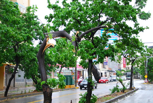
The wind howled like I have never heard it in my life. The windows held, but water seeped in through microscopic cracks in the wall, and seams around the windows. Ominous sounds emanated from various structures in the neighborhood as the high winds exposed shoddy construction methods and materials. Debris flew through the air creating a very real hazard to life and property. Then, almost as suddenly as it began, it was over....


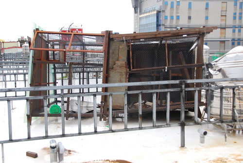
This is our neighbor's pidgen coop on the morning after. Notice the brown spot to rear of the property (right side of photo). The coop used to sit on that brown spot. It got blown down and over the fence and into the adjoining property, destroying one of the water tanks in the process.


I heard a crash and went up on the roof to see what had happened. I had tied down our picnic tables so I knew they were OK. Nevertheless, one of the tables was actually airborne, held down by the lanyards I had installed to hold down the umbrellas. But the tables weren't the problem. This ridiculously stupid pidgen coop had blown over and was resting at about a 45 degree angle on the fence separating the next property. Of course, I ran and told the owner, who of course did nothing about it. My offer to help him tie it down with nylon cord was met with indifference as he told me it was already tied down and wouldn't fly away.


I am just so tired of being right. My wife thinks I'm silly because I always want to inform the neighbors of things happening that I would appreciate knowing. This experience has reinforced the fact that people don't seem to care about anything, especially danger. My guess is that this guy will be whining about having to pay money to fix his neighbor's destroyed water tank, which was completely avoidable.


We had lost one of the covers on our own water tanks during the last typhoon. Now they are a matching set. I picked up the cover across the street in the parking lot. The retaining wire on the tank held though (on the right hand tank, visible in the large size photo). The winds were so strong that the force broke the weld on the cover handle and literally tore it off. Let me tell you, when I went up to the roof to check things out, it felt like I was being sandblasted by the rain!


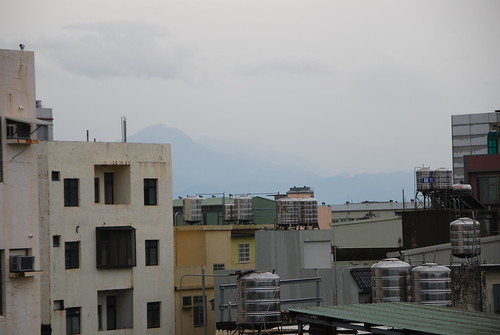
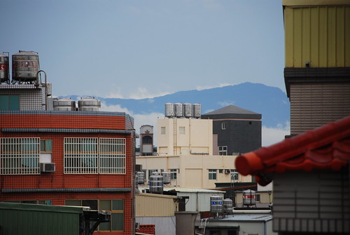
While up on the roof checking things out this morning, I noticed 2 new mountains that I never knew existed since I hadn't seen them before. The one cool thing about typhoons is that they really clear the air.


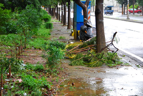
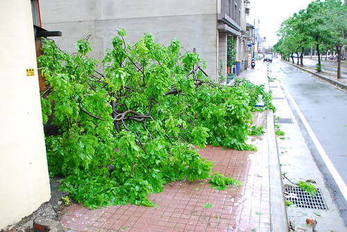
But, they trash the streets. Literally.


What else can you do but drag downed branches to the roadside?


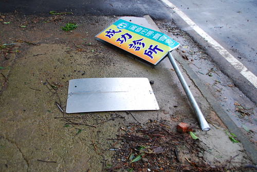
This sign post was bent over like a corn stalk in a crop circle. I'm officially impressed!


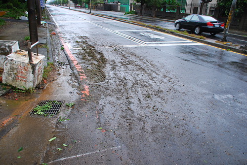
The mud pattern shows that a respectable volume of water had flowed down this street.


And the sewer system confirms that indeed a large volume of water had been absorbed into the system and was overflowing. In this shot, the water at the top of the photo is going out from the sewer system and not draining into it. The water level is above the grating.


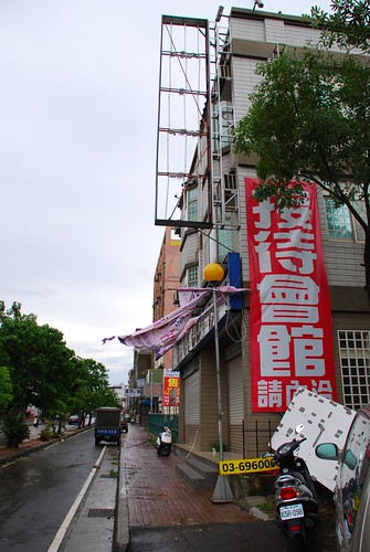
The real estate office lost their sign, which blew over the top of this building and landed behind it, next to our car. The sign then blew all the way down to the end of this street. Incredible as that sounds, the wind took it away like a leaf. I watched with fascination as the sign scaled the fence shown along side this building (easier to see on the large size) The fabric banners below are tattered.

I am inclined to think that maybe I would take stuff like that down, but typhoons are so commonplace in Taiwan that people don't expect much to happen.


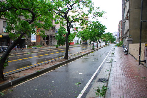
Our otherwise lovely street took a beating.


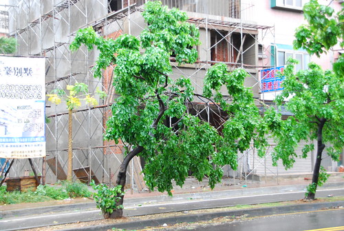
Most of the trees on this street are permanently malformed by high winds.


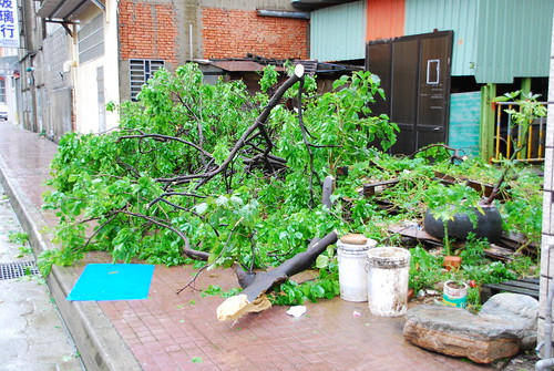
Someone had been busy removing all the broken branches and dragging them to this empty lot. Many of the branches have been sawn off.


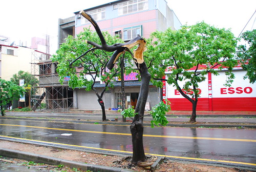
It takes a strong wind to do this to a tree.


Same pile of debris from the reverse angle. This used to be a short cut to get to Shao-hui's place.


This tree stands in mute testimony to the power of Krosa. It could have been a lot worse....

/>

technorati tags:, , , , , , ,

Blogged with Flock