
for Thursday, 03 April 2014 [8:03 PM PhT]
WEATHER.COM.PH TROPICAL CYCLONE UPDATES
TROPICAL DEPRESSION 05W (UNNAMED) UPDATE NUMBER 001
Issued at: 6:00 PM PhT (10:00 GMT) Thursday 03 April 2014
Next Update: 6:00 AM PhT (22:00 GMT) Friday 04 April 2014
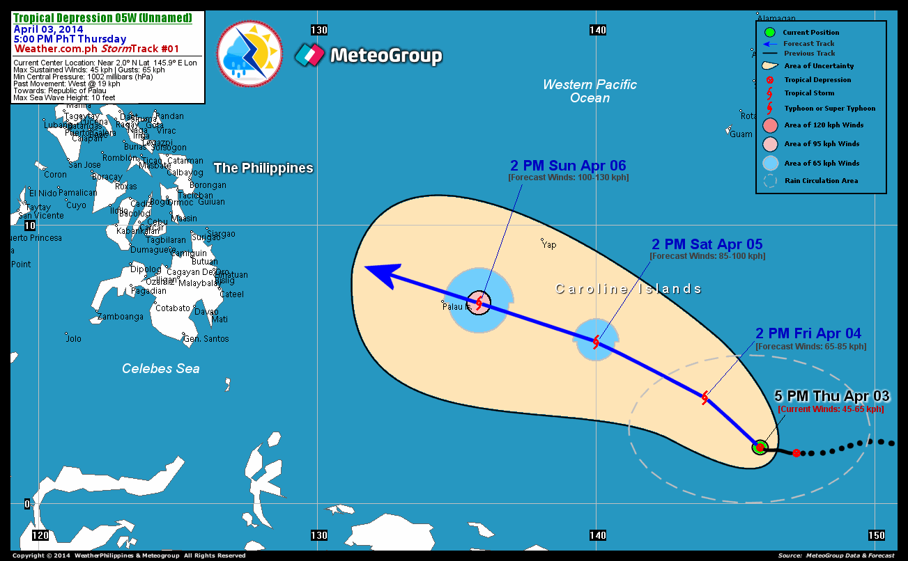
Tropical Depression 05W (Unnamed) has slightly accelerated while moving across the southern portion of the Caroline Islands...may gain latitude in the general direction of the Republic of Palau. This potential storm is forecast to enter the Philippine Area of Responsibility (PAR) on Sunday evening or Monday morning...and shall approach the eastern coastlines of Surigao, Leyte and Samar Provinces on Tuesday or Wednesday (April 08-09).
Residents and visitors along Western Micronesia and the Republic of Palau should closely monitor the development of TD 05W (Unnamed).
Information based on data collected by WeatherPhilippines Foundation, Inc. shall not be taken as official data. Weather information broadcasted and distributed by PAGASA remains as official data. WeatherPhilippines shall not be responsible for the private use and reliance of its weather information.
CURRENT CYCLONE INFORMATION
As of 5:00 PM PhT today...0900 GMT...
Location: Over the Southernmost Caroline Islands (near 2.0N 145.9E)
About: 1,395 km southeast of Koror, Palau...or 2,240 km east-southeast of Southern Mindanao, Philippines
Maximum Sustained Winds (1-min avg): 45 kph near the center...Gustiness: 65 kph
24 hr. Rain Accumulation (near and north of center): 2 to 50 mm [Slight to Heavy]
Past Movement: West at 19 kph
Forecast Movement: West-Northwest to Northwest at 15 kph
Towards: Republic of Palau
2-DAY FORECAST OUTLOOK*
05W is expected to move west-northwest within the next 12 hours with a turn to the northwest through 48 hours. On the forecast track, the core of TD 05W will remain over the open waters of the West Pacific Ocean through Saturday afternoon.
05W is expected to intensify throughout the forecast period...and could become a Tropical Storm (TS) by late Friday afternoon. Advance Intensity Forecast (AIF) shows its 1-minute maximum sustained winds increasing to 85 kph during the next 48 hours.
The following is the summary of the 2-day forecast outlook and an extended 3-day forecast on this system:
 FRIDAY AFTERNOON: Intensifies into a TS while moving NW across the Western Pacific Ocean...about 1,105 km ESE of Koror, Palau [2PM APR 04: 3.8N 143.9E @ 65kph]. SATURDAY AFTERNOON: Continues to intensify while over the Caroline Islands...about 625 km ESE of Koror, Palau [2PM APR 05: 5.8N 140.0E @ 85kph]. SUNDAY AFTERNOON: Approaching Palau as it nears Typhoon strength...about 145 km E of Koror, Palau [2PM APR 06: 7.2N 135.8E @ 100kph].
CYCLONE HAZARDS AFFECTING LAND
Below are the regions or places in the Philippines with possible or ongoing effects caused by the current tropical cyclone.
None.
Important Note: Please keep in mind that the above forecast outlook and hazards summary changes every 6 to 12 hrs!
ADDITIONAL DISTANCES & TECHNICAL INFO
Time/Date: 5:00 PM PhT Thu Apr 07, 2014
Class/Name: TD 05W (Unnamed)
Minimum Central Pressure: 1002 millibars (hPa)
Location of Center: Near 2.0º N Lat 145.9º E Lon
Distance 1: 1200 km SE of Yap Island
Distance 2: 1210 km E of P.A.R.
Distance 3: 1285 km S of Hagatna, Guam
Distance 4: 1395 km SE of Koror, Palau
Distance 5: 2240 km ESE of Southern Mindanao, PHL
T2K/WP StormTracks (for Public): GIF
CURRENT TRACKING MAP:
 _____________________________________________________________________________
__________________________________________________________________________________________________
CURRENT NOAA/MTSAT-2 INFRARED (IR) SATELLITE IMAGE:

__________________________________________________________________________________________________
>> To know the meteorological terminologies and acronyms used on this update visit the ff:
http://typhoon2000.ph/tcterm.htm
http://www.nhc.noaa.gov/aboutgloss.shtml
http://www.nhc.noaa.gov/acronyms.shtml
__________________________________________________________________________________________
For the complete details on TD 05W (UNNAMED)...go visit our website @:
> http://www.typhoon2000.com
> http://www.maybagyo.com
Copyright © 2014 Typhoon2000.com All Rights Reserved
| Reply via web post | Reply to sender | Reply to group | Start a New Topic | Messages in this topic (1) |

No comments:
Post a Comment