
for Saturday, 22 March 2014 [6:40 PM PhT]
WEATHER.COM.PH TROPICAL CYCLONE UPDATES
TROPICAL DEPRESSION 04W (CALOY) UPDATE NUMBER 002
Issued at: 6:00 PM PhT (10:00 GMT) Saturday 22 March 2014
Next Update: 6:00 AM PhT (22:00 GMT) Sunday 23 March 2014
Tropical Depression 04W (CALOY) has intensified slightly as it passed very close to the south of Siargao Island...now traversing Surigao City...expected to weaken within the next 12 to 24 hours.
04W (Caloy) will slightly enhance the cool surge of the Northeast Monsoon (Hanging Amihan) - bringing mostly cloudy conditions w/ passing drizzles, slight to sometimes moderate rains and gusty winds (not exceeding 50 kph) across the eastern sections of Luzon including Bicol Region and Northern Visayas this weekend.
Residents and visitors along Northern and NE Mindanao and the Visayas should closely monitor the development of TD 04W (Caloy).
Information based on data collected by WeatherPhilippines Foundation, Inc. shall not be taken as official data. Weather information broadcasted and distributed by PAGASA remains as official data. WeatherPhilippines shall not be responsible for the private use and reliance of its weather information.
CURRENT CYCLONE INFORMATION
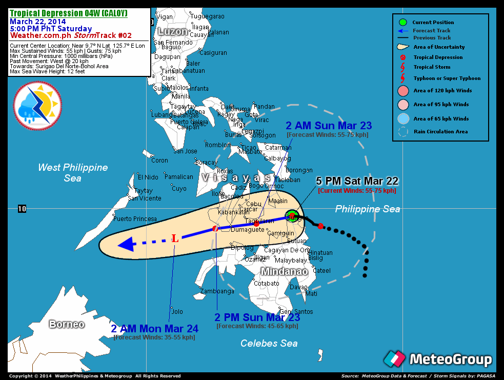
As of 5:00 PM PhT today...0900 GMT...
Location: In between the coasts of Siargao Island and Surigao Del Norte (near 9.7N 125.7E)
About: 25 km east-southeast of Surigao City...or 50 km west-southwest of Siargao Island
Maximum Sustained Winds (1-min avg): 55 kph near the center...Gustiness: 75 kph
24 hr. Rain Accumulation (near and north of center): 5 to 100 mm [Slight to Heavy]
Size (in diameter): 280 km (Very Small)
Past Movement: WNW at 20 kph
Forecast Movement: West to West-southwest at 17 kph
Towards: Surigao Del Norte-Bohol Area
1-DAY FORECAST OUTLOOK*
04W (Caloy) is expected to move westward within the next 12 hours with a slight dip towards the west-southwest through 36 hours. On the forecast track, the core of TD 04W (Caloy) will traverse Surigao Del Norte early tonight and enter Bohol Sea - passing in between Camiguin and Bohol after midnight tonight. On Sunday early morning, 04W will be just along the southern coast of Bohol and shall traverse Southern Negros - passing over or very close to Dumaguete City by late Sunday morning...and just along the southwest coast of Negros Sunday afternoon. TD 04W shall be over the Sulu Sea early Monday morning.
04W (Caloy) is expected to maintain its strength as it traverses Surigao Del Norte and Southern Visayas...and could dissipate into an area of low pressure off Sulu Sea on Monday morning. Advance Intensity Forecast (AIF) shows its 1-minute maximum sustained winds decreasing to 35 kph during the next 36 hours.
The following is the summary of the 1-day forecast outlook on this system:
 SUNDAY AFTERNOON: Weakening along the southwest coast of Negros...about 65 km W of Dumaguete City, Negros Oriental [2PM MAR 23: 9.4N 124.3E @ 55kph].
CYCLONE HAZARDS AFFECTING LAND
Below are the regions or places with possible or ongoing effects caused by the current tropical cyclone.
NORTHERN CARAGA / NORTHERN PART OF NORTHERN MINDANAO / EASTERN AND SOUTHERN SAMAR / SIARGAO AND DINAGAT ISLANDS / LEYTE / REST OF BOHOL / CAMIGUIN: Moderate to heavy rains of 30 to 50 mm will be experienced tonight until Sunday morning...becoming heavy rains of 50-100 mm across the provinces of Surigao Del Norte, Southern Leyte, Camiguin Island, and Southeastern Bohol. Residents living along the hazard-prone areas are advised to seek shelter and take precautionary measures against flashfloods and landslides.
Important Note: Please keep in mind that the above forecast outlook and hazards summary changes every 6 to 12 hrs!
ADDITIONAL DISTANCES & TECHNICAL INFO
Time/Date: 5:00 PM PhT Sat Mar 22, 2014
Class/Name: TD 04W (Caloy)
Minimum Central Pressure: 1000 millibars (hPa)
Location of Center: Near 9.7º N Lat 125.7º E Lon
Distance 1: 25 km ESE of Surigao City
Distance 2: 50 km WSW of Siargao Island
Distance 3: 90 km NNE of Butuan City
Distance 4: 125 km SE of Maasin City
Distance 5: 210 km E of Tagbilaran City
T2K/WP StormTracks (for Public): GIF
CURRENT TRACKING MAP:
 _____________________________________________________________________________
__________________________________________________________________________________________________
CURRENT NOAA/MTSAT-2 INFRARED (IR) SATELLITE IMAGE:

__________________________________________________________________________________________________
>> To know the meteorological terminologies and acronyms used on this update visit the ff:
http://typhoon2000.ph/tcterm.htm
http://www.nhc.noaa.gov/aboutgloss.shtml
http://www.nhc.noaa.gov/acronyms.shtml
__________________________________________________________________________________________
For the complete details on TD 04W (CALOY)...go visit our website @:
> http://www.typhoon2000.com
> http://www.maybagyo.com
<<<Typhoon2000.com Mobile >>>
Get the latest SMS Storm Alerts!
For more details: Text T2K TYPHOON to
2800 (Globe/TM) | Offline (Smart/TNT) | 2288 (Sun)
*Only P2.50 (Smart/Globe) / P2.00 (Sun) per msg received.
Click here on how to use this service (in PDF file)
Powered by: Synermaxx Corporation
Copyright © 2014 Typhoon2000.com All Rights Reserved
| Reply via web post | Reply to sender | Reply to group | Start a New Topic | Messages in this topic (1) |

No comments:
Post a Comment