Sunday, September 30, 2007

TD HANNA (90W) - Update #006


Typhoon2000 STORM UPDATE #006
Name: TROPICAL DEPRESSION HANNA [90W] 
Issued: 7:00 AM MANILA TIME (23:00 GMT) SUN 30 SEPTEMBER 2007
Next Update: 7:00 PM (11:00 GMT) SUN 30 SEPTEMBER
Source: JMA TC ADVISORY (29/2100Z)
Note: Kindly refer to your country's official warnings or bulletins. This update is for additional information purposes only.
_____________________________________________________________________________
 
 
TROPICAL DEPRESSION HANNA (90W) TRYING TO CONSOLIDATE OVER THE
SOUTH
CHINA SEA WHILE MOVING UNDER MODERATE WIND SHEAR CONDITIONS...MAY BE
A BIG THREAT TO VIETNAM IN THE COMING DAYS.

+ FORECAST OUTLOOK: HANNA is expected to continue moving West to WSW
across the South China Sea within 12-24 hours. It is likely to gain
strength as soon as it moves across favorable atmospheric conditions
along the
South China Sea. The 3 to 5-day forecast shows HANNA beco-
ming a strong Tropical Cyclone affecting the eastern coast of Vietnam.
Watch out for more forecast outlook soon

+ EFFECTS: HANNA's rain bands is now well over the South China Sea,
however, the SW outermost bands is currently approaching Vietnam,
which is also a part of the SW Monsoon. Cloudy skies with passing
light to moderate and sometimes heavy downpour can be expected along
Hanna's outer bands. Flash floods and mudslides are imminent along
river banks, low-lying and mountainous regions of the affected areas.

+ CURRENT ITCZ/MONSOON INTENSITY: Moderate to strong Southwest (SW)
Monsoon enhanced by HANNA will continue to bring cloudy skies with
rains & South to SW'ly winds of 20 km/hr or higher across Western
Philippines becoming more frequent over NCR, Western Luzon, Western
Visayas, Southern Luzon and Bicol Region. Landslides and flooding
is likely to occur along steep mountain slopes, river banks, low-
lying & flood-prone areas of the affected areas.
 
Important Note: Please keep in mind that the above forecast outlook,
effects & current monsoon intensity, and tropical cyclone watch changes 
every 06 to 12 hours!

_____________________________________________________________________________

TIME/DATE: 5:00 AM MANILA TIME (21:00 GMT) 30 SEPTEMBER
LOCATION OF CENTER: LATITUDE 15.4º N...LONGITUDE 117.0º E
DISTANCE 1: 360 KM (195
NM) WSW OF DAGUPAN CITY, PH
DISTANCE 2: 400 KM (215 NM) WSW OF BAGUIO CITY, PH
DISTANCE 3: 320 KM (173 NM) WNW OF IBA, ZAMBALES, PH
DISTANCE 4: 360 KM (195 NM) WNW OF SUBIC BAY, PH
DISTANCE 5: 450 KM (245 NM) NW OF METRO MANILA, PH
MAX SUSTAINED WINDS [10-MIN AVG]: 55 KM/HR (30 KTS)
PEAK WIND GUSTS: 85 KM/HR (45 KTS)
SAFFIR-SIMPSON SCALE: N/A
MINIMUM CENTRAL PRESSURE (est.): 996 MILLIBARS (hPa)
RECENT MOVEMENT: WSW @ 19 KM/HR (10 KTS)
GENERAL DIRECTION: VIETNAM
STORM'S SIZE (IN DIAMETER): 630 KM (340 NM)/AVERAGE
MAX WAVE HEIGHT**: 10 FEET (3.0 METERS)
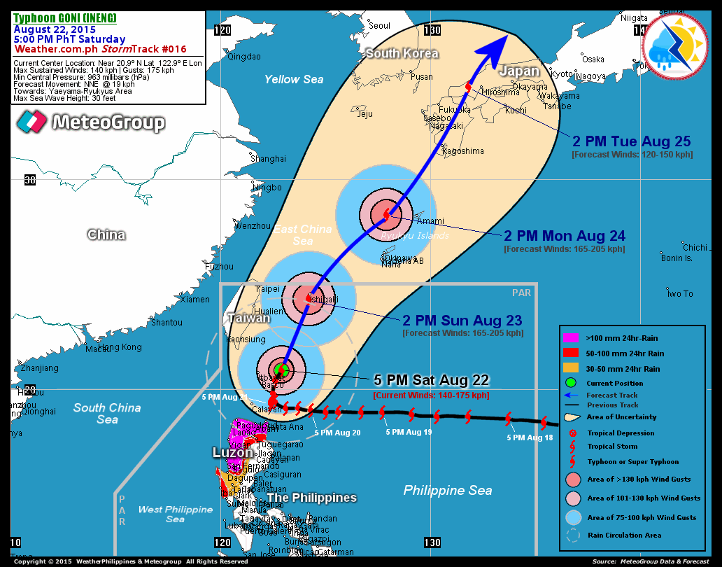
VIEW TRACKING MAP: 5 AM MANILA TIME SUN SEPTEMBER 30

PHILIPPINE STORM SIGNALS*:
#01 - NOW LOWERED.

REMARKS: 2 AM (18 GMT) 30 SEPTEMBER POSITION: 16.0N 117.3E.
^
...(more)
_____________________________________________________________________________
 
PAGASA CURRENT POSITION, MOVEMENT AND INTENSITY (10-min. ave.): 
> 4 AM (20 GMT) 30 SEPTEMBER: 16.1N 117.0E / WSW @ 22 KPH / 55 kph

:: For the complete PAGASA bulletin/track, kindly visit their website at: 
   
http://www.pagasa.dost.gov.ph/wb/tcupdate.shtml
_____________________________________________________________________________

RECENT TRACKING CHART:


_______________________________________________________________________________________

 
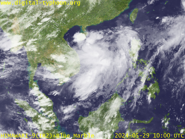
RECENT MTSAT-1R SATELLITE IMAGE:


> Image source:  Digital-Typhoon.org (Nat'l. Institute of Informatics) (http://www.digital-typhoon.org)
__________________________________________________________________________________________

NOTES:
 
  ^ - JTWC commentary remarks (for Meteorologists) from their 
      latest warning.
 
  * - Based on PAGASA's Philippine Storm Warning Signals, 
      # 4 being the highest. Red letters indicate new areas 
      being hoisted.
For more explanations on these signals, 
      visit:
http://www.typhoon2000.ph/signals.htm

 ** - Based on the Tropical Cyclone's Wave Height near 
      its center.

__________________________________________________________________________________________

>>
To know the meteorological terminologies and acronyms 
   used on this update visit the ff:

    http://typhoon2000.ph/tcterm.htm  
    http://www.nhc.noaa.gov/aboutgloss.shtml
    http://www.srh.noaa.gov/oun/severewx/glossary.php
    http://www.srh.weather.gov/fwd/glossarynation.html
    http://www.nhc.noaa.gov/acronyms.shtml
__________________________________________________________________________________________

:: Typhoon2000.com (T2K) Mobile >> Powered by: Synermaxx
Receive the latest storm updates directly to your mobile phones! To know more:
Send T2K HELP to: 2800
(GLOBE & TM) | 216 (SMART & TNT) | 2288 (SUN) 
Note: Globe & Smart charges P2.50 per message, while Sun at P2.00.
__________________________________________________________________________________________

For the complete details on TD HANNA (90W)...go visit
our website @:

>
http://www.typhoon2000.com
http://www.maybagyo.com

:: Kindly view our site's disclaimer at: 
   
http://www.typhoon2000.ph/disclaimer.htm


__._,_.___
Recent Activity
Visit Your Group
Featured Y! Groups

and category pages.

There is something

for everyone.

Real Food Group

Share recipes

and favorite meals

w/ Real Food lovers.

Athletic Edge

A Yahoo! Group

to connect w/ others

about fitness goals.

.

__,_._,___

TD HANNA (90W) - Update #005


Typhoon2000 STORM UPDATE #005
Name: TROPICAL DEPRESSION HANNA [90W] 
Issued: 9:00 PM MANILA TIME (13:00 GMT) SAT 29 SEPTEMBER 2007
Next Update: 7:00 AM (23:00 GMT) SUN 30 SEPTEMBER
Source: T2K UNOFFICIAL TC ADVISORY #009
Note: Kindly refer to your country's official warnings or bulletins. This update is for additional information purposes only.
_____________________________________________________________________________
 
 
TROPICAL DEPRESSION HANNA (90W) 
HAS ACCELERATED WEST-SOUTHWEST ACROSS
LUZON, PASSING OVER THE PROVINCES OF NUEVA VIZCAYA, NUEVA ECIJA, AND
PANGASINAN THIS AFTERNOON...NOW OFF THE COAST OF ZAMBALES. WIDESPREAD
RAINS CONTINUES ACROSS WESTERN LUZON.

+ FORECAST OUTLOOK: HANNA is expected to continue moving West to WSW
across the South China Sea within 24 hours. It is likely to gain
strength as it moves across favorable atmospheric conditions of the
South China Sea. The 3 to 5-day forecast shows HANNA becoming a strong
Tropical Cyclone affecting the eastern coast of Vietnam. Watch out for
more forecast outlook soon

+ EFFECTS: HANNA's rain bands continues to spread across the island of
Luzon (except for Bicol Region) becoming more intense along the Western
and Central sections particularly along mountain regions of Zambales,
Benguet and Cordillera. Cloudy skies with widespread rains can be
expected along these bands. Flash floods and mudslides are imminent
along river banks, low-lying and mountainous regions of the affected
areas.

+ CURRENT ITCZ/MONSOON INTENSITY: Moderate to strong Southwest (SW)
Monsoon enhanced by HANNA will continue to bring cloudy skies with
rains & SW'ly winds of 20 km/hr or higher across Western Philippines
becoming more frequent over Sulu Sea, Palawan, Mindoro, Western and
Central Visayas and Western Mindanao. Landslides and flooding is
likely to occur along steep mountain slopes, river banks, low-lying
& flood-prone areas of the affected areas.
 
Important Note: Please keep in mind that the above forecast outlook,
effects & current monsoon intensity, and tropical cyclone watch changes 
every 06 to 12 hours!

_____________________________________________________________________________

TIME/DATE: 6:00 PM MANILA TIME (10:00 GMT) 29 SEPTEMBER
LOCATION OF CENTER: LATITUDE 15.6º N...LONGITUDE 118.9º E {T2K SATFIX} 
DISTANCE 1: 155 KM (83
NM) WSW OF DAGUPAN CITY, PH
DISTANCE 2: 200 KM (108 NM) WSW OF BAGUIO CITY, PH
DISTANCE 3: 125 KM (67 NM) WNW OF IBA, ZAMBALES, PH
DISTANCE 4: 175 KM (95 NM) NW OF SUBIC BAY, PH
DISTANCE 5: 260 KM (140 NM) NW OF METRO MANILA, PH
MAX SUSTAINED WINDS [1-MIN AVG]: 45 KM/HR (25 KTS)
PEAK WIND GUSTS: 65 KM/HR (35 KTS)
SAFFIR-SIMPSON SCALE: N/A
MINIMUM CENTRAL PRESSURE (est.): 1002 MILLIBARS (hPa)
RECENT MOVEMENT: WSW @ 33 KM/HR (18 KTS)
GENERAL DIRECTION: SOUTH CHINA SEA
STORM'S SIZE (IN DIAMETER): 630 KM (340 NM)/AVERAGE
MAX WAVE HEIGHT**: 9 FEET (2.7 METERS)
VIEW T2K TRACKING MAP: 6 PM MANILA TIME SAT SEPTEMBER 29

PHILIPPINE STORM SIGNALS*:
#01 - ABRA, KALINGA, ILOCOS SUR, MT. PROVINCE, IFUGAO, BENGUET,
      LA UNION, NUEVA VIZCAYA, NUEVA ECIJA, PANGASINAN, TARLAC,
      ZAMBALES, PAMPANGA, BATAAN AND BULACAN.

REMARKS: 2 PM (06 GMT) 29 SEPTEMBER POSITION: 15.7N 120.5E.
^
...(more)
_____________________________________________________________________________
 
PAGASA CURRENT POSITION, MOVEMENT AND INTENSITY (10-min. ave.): 
> 4 PM (08 GMT) 29 SEPTEMBER: 16.5N 120.6E / W @ 22 KPH / 55 kph

:: For the complete PAGASA bulletin/track, kindly visit their website at: 
   
http://www.pagasa.dost.gov.ph/wb/tcupdate.shtml
_____________________________________________________________________________

RECENT T2K TRACKING CHART:


_______________________________________________________________________________________

 
RECENT MTSAT-1R SATELLITE IMAGE:


> Image source:  Digital-Typhoon.org (Nat'l. Institute of Informatics) (http://www.digital-typhoon.org)
__________________________________________________________________________________________

NOTES:
 
  ^ - JTWC commentary remarks (for Meteorologists) from their 
      latest warning.
 
  * - Based on PAGASA's Philippine Storm Warning Signals, 
      # 4 being the highest. Red letters indicate new areas 
      being hoisted.
For more explanations on these signals, 
      visit:
http://www.typhoon2000.ph/signals.htm

 ** - Based on the Tropical Cyclone's Wave Height near 
      its center.

__________________________________________________________________________________________

>>
To know the meteorological terminologies and acronyms 
   used on this update visit the ff:

    http://typhoon2000.ph/tcterm.htm  
    http://www.nhc.noaa.gov/aboutgloss.shtml
    http://www.srh.noaa.gov/oun/severewx/glossary.php
    http://www.srh.weather.gov/fwd/glossarynation.html
    http://www.nhc.noaa.gov/acronyms.shtml
__________________________________________________________________________________________

:: Typhoon2000.com (T2K) Mobile >> Powered by: Synermaxx
Receive the latest storm updates directly to your mobile phones! To know more:
Send T2K HELP to: 2800
(GLOBE & TM) | 216 (SMART & TNT) | 2288 (SUN) 
Note: Globe & Smart charges P2.50 per message, while Sun at P2.00.
__________________________________________________________________________________________

For the complete details on TD HANNA (90W)...go visit
our website @:

>
http://www.typhoon2000.com
http://www.maybagyo.com

:: Kindly view our site's disclaimer at: 
   
http://www.typhoon2000.ph/disclaimer.htm


__._,_.___
Recent Activity
Visit Your Group
Yahoo! Groups

Get info and support

on Samsung HDTVs

and devices.

Shedding Pounds

on Yahoo! Groups

Read sucess stories

& share your own.

Dog Groups

on Yahoo! Groups

discuss everything

related to dogs.

.

__,_._,___

Saturday, September 29, 2007

TD HANNA (98W) - Update #004


Typhoon2000 STORM UPDATE #004
Name: TROPICAL DEPRESSION HANNA [98W] 
Issued: 8:00 AM MANILA TIME (00:00 GMT) SAT 29 SEPTEMBER 2007
Next Update: 7:00 PM (11:00 GMT) SAT 29 SEPTEMBER
Source: T2K UNOFFICIAL TC ADVISORY #007
Note: Kindly refer to your country's official warnings or bulletins. This update is for additional information purposes only.
_____________________________________________________________________________
 
 
TROPICAL DEPRESSION HANNA (98W) 
MAY BRIEFLY BECOME A TROPICAL STORM
BASED ON THE LATEST 6:57 AM SATELLITE IMAGERY, BEFORE MAKING LANDFALL
OVER AURORA THIS MORNING.

+ FORECAST OUTLOOK: HANNA is expected to move WNW within 12 hours and
cross Luzon via Aurora this morning and shall pass over the provinces
of Quirino, Benguet & La Union this afternoon. The ill-defined center
of HANNA shall be off the coast of La Union tonight and be over the
South China Sea early tomorrow morning (Sunday Sep 30)

+ EFFECTS: HANNA's rain bands continues to spread across the island of
Luzon becoming more intense along the Eastern and Central sections
particularly along mountain slopes of Sierra Madre Mountains (along
Northern Quezon-Aurora-Isabela Area). Cloudy skies with widespread
rains can be expected along these bands. People living around the
slopes of Mayon Volcano in Albay especially along the area where po-
ssible LAHAR FLOWS (mixture of volcanic mud and water) are located -
must stay alert as moderate to heavy rains are possible today. Flash
floods and mudslides are imminent along river banks, low-lying and
mountainous regions of the affected areas. Precautionary measures
must be initiated as the depression approaches.

+ CURRENT ITCZ/MONSOON INTENSITY: Active ITCZ (Monsoon Trough) embedded
along the wet-phase of the Madden-Julian Oscillation (MJO) will con-
tinue to bring cloudy skies with rainshowers & thunderstorms across
the Philippines becoming more frequent over the eastern & central
sections of the country. Landslides and flooding is likely to occur
along steep mountain slopes, river banks, low-lying & flood-prone
areas of the affected areas. Southwest (SW) Monsoon enhanced by HANNA,
currently affecting Western & Southern Mindanao, Western Visayas,
Palawan and Sulu Sea.
 
Important Note: Please keep in mind that the above forecast outlook,
effects & current monsoon intensity, and tropical cyclone watch changes 
every 06 to 12 hours!

_____________________________________________________________________________

TIME/DATE: 7:00 AM MANILA TIME (23:00 GMT) 29 SEPTEMBER
LOCATION OF CENTER: LATITUDE 15.8º N...LONGITUDE 122.9º E {T2K SATFIX} 
DISTANCE 1: 85 KM (45
NM) ESE OF CASIGURAN, AURORA, PH
DISTANCE 2: 130 KM (70 NM) ENE OF BALER, AURORA, PH
DISTANCE 3: 250 KM (135 NM) NNW OF NAGA CITY, PH
DISTANCE 4: 225 KM (122 NM) NE OF METRO MANILA, PH
MAX SUSTAINED WINDS [1-MIN AVG]: 60 KM/HR (33 KTS)
PEAK WIND GUSTS: 80 KM/HR (43 KTS)
SAFFIR-SIMPSON SCALE: N/A
MINIMUM CENTRAL PRESSURE (est.): 1000 MILLIBARS (hPa)
RECENT MOVEMENT: WNW @ 22 KM/HR (12 KTS)
GENERAL DIRECTION: AURORA-QUIRINO AREA
STORM'S SIZE (IN DIAMETER): 555 KM (300 NM)/N/A
MAX WAVE HEIGHT**: 10 FEET (3.0 METERS)
VIEW TRACKING MAP: 7 AM MANILA TIME SAT SEPTEMBER 29

PHILIPPINE STORM SIGNALS*:
#02 - CATANDUANES, CAMARINES SUR, CAMARINES NORTE, POLILLO ISLAND,
      NORTHERN QUEZON, AURORA, QUIRINO, & ISABELA.
#01 - METRO MANILA AND THE WHOLE OF LUZON.

REMARKS: 5 AM (21 GMT) 29 SEPTEMBER POSITION: 15.6N 123.9E.
^
...(more)
_____________________________________________________________________________
 
PAGASA CURRENT POSITION, MOVEMENT AND INTENSITY (10-min. ave.): 
> 4 AM (20 GMT) 29 SEPTEMBER: 16.3N 122.8E / WNW @ 20 KPH / 65 kph

:: For the complete PAGASA bulletin/track, kindly visit their website at: 
   
http://www.pagasa.dost.gov.ph/wb/tcupdate.shtml
_____________________________________________________________________________

RECENT T2K TRACKING CHART:


_______________________________________________________________________________________

 
RECENT MTSAT-1R SATELLITE IMAGE:


> Image source:  Digital-Typhoon.org (Nat'l. Institute of Informatics) (http://www.digital-typhoon.org)
__________________________________________________________________________________________

NOTES:
 
  ^ - JTWC commentary remarks (for Meteorologists) from their 
      latest warning.
 
  * - Based on PAGASA's Philippine Storm Warning Signals, 
      # 4 being the highest. Red letters indicate new areas 
      being hoisted.
For more explanations on these signals, 
      visit:
http://www.typhoon2000.ph/signals.htm

 ** - Based on the Tropical Cyclone's Wave Height near 
      its center.

__________________________________________________________________________________________

>>
To know the meteorological terminologies and acronyms 
   used on this update visit the ff:

    http://typhoon2000.ph/tcterm.htm  
    http://www.nhc.noaa.gov/aboutgloss.shtml
    http://www.srh.noaa.gov/oun/severewx/glossary.php
    http://www.srh.weather.gov/fwd/glossarynation.html
    http://www.nhc.noaa.gov/acronyms.shtml
__________________________________________________________________________________________

:: Typhoon2000.com (T2K) Mobile >> Powered by: Synermaxx
Receive the latest storm updates directly to your mobile phones! To know more:
Send T2K HELP to: 2800
(GLOBE & TM) | 216 (SMART & TNT) | 2288 (SUN) 
Note: Globe & Smart charges P2.50 per message, while Sun at P2.00.
__________________________________________________________________________________________

For the complete details on TD HANNA (98W)...go visit
our website @:

>
http://www.typhoon2000.com
http://www.maybagyo.com

:: Kindly view our site's disclaimer at: 
   
http://www.typhoon2000.ph/disclaimer.htm


__._,_.___
Recent Activity
Visit Your Group
Popular Y! Groups

Is your group one?

Check it out and

see.

Fashion Groups

on Yahoo! Groups

A great place to

connect and share.

Dog Fanatics

on Yahoo! Groups

Find people who are

crazy about dogs.

.

__,_._,___

Friday, September 28, 2007

TD HANNA (98W) - Update #003


Typhoon2000 STORM UPDATE #003
Name: TROPICAL DEPRESSION HANNA [98W] 
Issued: 7:00 PM MANILA TIME (11:00 GMT) FRI 28 SEPTEMBER 2007
Next Update: 7:00 AM (23:00 GMT) SAT 29 SEPTEMBER
Source: T2K UNOFFICIAL TC ADVISORY #005
Note: Kindly refer to your country's official warnings or bulletins. This update is for additional information purposes only.
_____________________________________________________________________________
 
 
TROPICAL DEPRESSION HANNA (98W) 
SLOWS DOWN AS ITS MID-LEVEL CIRCULA-
TION HAS MOVED WEST INTO LUZON, LEAVING ITS LOW-LEVEL CIRCULATION
CENTER PARTIALLY EXPOSED OVER THE PHILIPPINE SEA, JUST TO THE EAST OF
CATANDUANES ISLAND.

+ FORECAST OUTLOOK: HANNA is expected to continue tracking West to WNW
the next 2-3 days with its partially exposed LLCC moving across Northern
Bicol and Northern Quezon tomorrow morning...At this moment, a moderate
Southerly Shear (upper level winds) is likely to weaken HANNA into a
Tropical Disturbance (LPA) if the mid-level circulation continues to
separate from the LLCC

+ EFFECTS: HANNA's outer bands now spreading across the island of Luzon
becoming more intense along the Eastern and Central sections particu-
larly along mountain slopes of Sierra Madre Mountains. Cloudy skies
with widespread rains can be expected along these bands. People living
around the slopes of Mayon Volcano in Albay especially along the area
where possible LAHAR FLOWS (mixture of volcanic mud and water) are lo-
cated - must stay alert as moderate to heavy rains are possible today.
Flash floods and mudslides are imminent along river banks, low-lying
and mountainous regions of the affected areas. Precautionary measures
must be initiated as the depression approaches.

+ CURRENT ITCZ/MONSOON INTENSITY: Active ITCZ (Monsoon Trough) embedded
along the wet-phase of the Madden-Julian Oscillation (MJO) will continue
to bring cloudy skies with rainshowers & thunderstorms across the Phili-
ppines becoming more frequent over the eastern & central sections of the
country. Landslides and flooding is likely to occur along steep mountain
slopes, river banks, low-lying & flood-prone areas of the affected areas.
Southwest (SW) Monsoon enhanced by HANNA, currently affecting Western &
Southern Mindanao, Western Visayas, Palawan and Sulu Sea.
 
Important Note: Please keep in mind that the above forecast outlook,
effects & current monsoon intensity, and tropical cyclone watch changes 
every 06 to 12 hours!

_____________________________________________________________________________

TIME/DATE: 5:00 PM MANILA TIME (09:00 GMT) 28 SEPTEMBER
LOCATION OF CENTER: LATITUDE 14.0º N...LONGITUDE 126.5º E {T2K SATFIX} 
DISTANCE 1: 240 KM (130
NM) ENE OF VIRAC, CATANDUANES, PH
DISTANCE 2: 320 KM (173 NM) ENE OF LEGAZPI CITY, PH
DISTANCE 3: 360 KM (195 NM) ENE OF NAGA CITY, PH
DISTANCE 4: 585 KM (315 NM) ESE OF METRO MANILA, PH
MAX SUSTAINED WINDS [1-MIN AVG]: 45 KM/HR (25 KTS)
PEAK WIND GUSTS: 65 KM/HR (35 KTS)
SAFFIR-SIMPSON SCALE: N/A
MINIMUM CENTRAL PRESSURE (est.): 1003 MILLIBARS (hPa)
RECENT MOVEMENT: WSW @ 20 KM/HR (11 KTS)
GENERAL DIRECTION: NORTHERN BICOL-QUEZON AREA
STORM'S SIZE (IN DIAMETER): 555 KM (300 NM)/N/A
MAX WAVE HEIGHT**: 10 FEET (3.0 METERS)
VIEW TRACKING MAP: 5 PM MANILA TIME FRI SEPTEMBER 28

PHILIPPINE STORM SIGNALS*:
#02 - CATANDUANES, CAMARINES SUR, CAMARINES NORTE, POLILLO ISLAND,
      NORTHERN QUEZON, AURORA, QUIRINO, & ISABELA.
#01 - CAGAYAN, KALINGA, MOUNTAIN PROVINCE, IFUGAO, BENGUET, NUEVA
      ECIJA, NUEVA VIZCAYA, BULACAN, RIZAL, LAGUNA, CAVITE, BATANGAS,
      REST OF QUEZON, MARINDUQUE, BURIAS IS., ALBAY, SORSOGON,
      METRO MANILA.

REMARKS: 2 PM (06 GMT) 28 SEPTEMBER POSITION: 14.5N 128.5E.
^
...(more)
_____________________________________________________________________________
 
PAGASA CURRENT POSITION, MOVEMENT AND INTENSITY (10-min. ave.): 
> 4 PM (08 GMT) 28 SEPTEMBER: 15.6N 125.9E / WNW @ 20 KPH / 65 kph

:: For the complete PAGASA bulletin/track, kindly visit their website at: 
   
http://www.pagasa.dost.gov.ph/wb/tcupdate.shtml
_____________________________________________________________________________

RECENT T2K TRACKING CHART:


_______________________________________________________________________________________

 
RECENT MTSAT-1R SATELLITE IMAGE:


> Image source:  Digital-Typhoon.org (Nat'l. Institute of Informatics) (http://www.digital-typhoon.org)
__________________________________________________________________________________________

NOTES:
 
  ^ - JTWC commentary remarks (for Meteorologists) from their 
      latest warning.
 
  * - Based on PAGASA's Philippine Storm Warning Signals, 
      # 4 being the highest. Red letters indicate new areas 
      being hoisted.
For more explanations on these signals, 
      visit:
http://www.typhoon2000.ph/signals.htm

 ** - Based on the Tropical Cyclone's Wave Height near 
      its center.

__________________________________________________________________________________________

>>
To know the meteorological terminologies and acronyms 
   used on this update visit the ff:

    http://typhoon2000.ph/tcterm.htm  
    http://www.nhc.noaa.gov/aboutgloss.shtml
    http://www.srh.noaa.gov/oun/severewx/glossary.php
    http://www.srh.weather.gov/fwd/glossarynation.html
    http://www.nhc.noaa.gov/acronyms.shtml
__________________________________________________________________________________________

:: Typhoon2000.com (T2K) Mobile >> Powered by: Synermaxx
Receive the latest storm updates directly to your mobile phones! To know more:
Send T2K HELP to: 2800
(GLOBE & TM) | 216 (SMART & TNT) | 2288 (SUN) 
Note: Globe & Smart charges P2.50 per message, while Sun at P2.00.
__________________________________________________________________________________________

For the complete details on TD HANNA (98W)...go visit
our website @:

>
http://www.typhoon2000.com
http://www.maybagyo.com

:: Kindly view our site's disclaimer at: 
   
http://www.typhoon2000.ph/disclaimer.htm


__._,_.___
Recent Activity
Visit Your Group
Dog Groups

on Yahoo! Groups

discuss everything

related to dogs.

Yahoo! Groups

Going Green

Share your passion

for the planet.

Best of Y! Groups

Discover groups

that are the best

of their class.

.

__,_._,___