Typhoon2000 STORM UPDATE #012
Name: TYPHOON CIMARON [PAENG/22W/0619]
Issued: 7:00 AM MANILA TIME (23:00 GMT) THU 02 NOVEMBER 2006
Next Update: 7:00 AM (23:00 GMT) FRI 03 NOVEMBER 2006
Source: JTWC TROPICAL CYCLONE WARNING #025
_______________________________________________________________________
Source: JTWC TROPICAL CYCLONE WARNING #025
____________
TYPHOON CIMARON (PAENG) HAS REGAINED ITS STRENGTH BACK
TO A CATEGORY THREE (205 KM/HR) SYSTEM LAST NIGHT, BUT
WEAKENED ANEW DOWN TO CATEGORY TWO...BARELY NOT MOVING
OVER THE CENTRAL SOUTH CHINA SEA.
...ALL INTERESTS IN THE SOUTHERN CHINA AND VIETNAM SHOULD
TO A CATEGORY THREE (205 KM/HR) SYSTEM LAST NIGHT, BUT
WEAKENED ANEW DOWN TO CATEGORY TWO...BARELY NOT MOVING
OVER THE CENTRAL SOUTH CHINA SEA.
...ALL INTERESTS IN THE SOUTHERN CHINA AND VIETNAM SHOULD
CLOSELY MONITOR THE PROGRESS OF THIS ERRATIC TYPHOON.
+ FORECAST OUTLOOK: CIMARON is expected to drift NE for the next 24 to 48 hours and weaken into a Tropical Storm.
The 3 to 4-day (Nov 5-6) long-range forecast shows CIMARON
turning SW'ly and dissipate due to unfavorable atmospheric
environment surrounding the cyclone.
+ EFFECTS: The system's circulation remains over the South
China Sea and is not affecting any landmass.
outlook, effects & current monsoon intensity, and tropical
cyclone watch changes every 06 to 12 hours!
____________
TIME/DATE: 5:00 AM MANILA TIME (21:00 GMT) 02 NOVEMBER
LOCATION OF EYE: LATITUDE 19.1º N...LONGITUDE 116.4º E
DISTANCE 1: 425 KM (230 NM) SE OF HONG KONG, CHINA
DISTANCE 2: 620 KM (335 NM) EAST OF QIONGHAI, HAINAN IS.
PEAK WIND GUSTS: 215 KM/HR (115 KTS)
SAFFIR-SIMPSON SCALE: CATEGORY TWO (2)
MINIMUM CENTRAL PRESSURE (est.): 949 MILLIBARS (hPa)
RECENT MOVEMENT: NE @ 02 KM/HR (01 KT)
GENERAL DIRECTION: SOUTH CHINA SEA
STORM'S SIZE (IN DIAMETER): 610 KM (330 NM)/AVERAGE
MAX WAVE HEIGHT**: 35 FEET (10.6 METERS)
VIEW TRACKING MAP: 2 AM HKT THU NOVEMBER 02
TSR WIND PROBABILITIES: CURRENT TO 96 HRS LEAD
PHILIPPINE STORM SIGNALS*: None
DISTANCE 3: 455 KM (245 NM) WNW OF LAOAG CITY, PH
MAX SUSTAINED WINDS [1-MIN AVG]: 175 KM/HR (95 KTS)PEAK WIND GUSTS: 215 KM/HR (115 KTS)
SAFFIR-SIMPSON SCALE: CATEGORY TWO (2)
MINIMUM CENTRAL PRESSURE (est.): 949 MILLIBARS (hPa)
RECENT MOVEMENT: NE @ 02 KM/HR (01 KT)
GENERAL DIRECTION: SOUTH CHINA SEA
STORM'S SIZE (IN DIAMETER): 610 KM (330 NM)/AVERAGE
MAX WAVE HEIGHT**: 35 FEET (10.6 METERS)
VIEW TRACKING MAP: 2 AM HKT THU NOVEMBER 02
TSR WIND PROBABILITIES: CURRENT TO 96 HRS LEAD
PHILIPPINE STORM SIGNALS*: None
12, 24 & 48 HR. FORECAST:
2 PM (06 GMT) 02 NOV: 19.3N 116.6E / 150-185 KPH / NE @ 02 KPH
2 AM (18 GMT) 03 NOV: 19.5N 116.8E / 120-150 KPH / NE @ 02 KPH
2 AM (18 GMT) 04 NOV: 19.9N 117.1E / 85-100 KPH / WEST @ 02 KPH
REMARKS: 2 AM (18 GMT) 02 NOVEMBER POSITION: 19.1N 116.4E.
^TY CIMARON REMAINS IN A VERY WEAK STEERING FLOW ENVIRON-
MENT BETWEEN THE SUBTROPICAL RIDGE TO THE EAST AND THE
SUBTROPICAL RIDGE WEST OF THE SYSTEM. THIS FORECAST RE-
PRESENTS A SIGNIFICANT DEPARTURE FROM THE PREVIOUS FORE-
CAST AND REFLECTS A SLOW, QUASISTATIONARY TRACK NORTHWARD
UNDER INCREASING, HIGH VERTICAL WIND SHEAR (VWS). TY CIMA-
RON WILL WEAKEN RAPIDLY, ESPECIALLY AFTER 36 HOURS DUE TO
INTERACTION WITH AN APPROACHING MIDLATITUDE TROUGH. THE
SYSTEM IS THEN EXPECTED TO TURN SOUTHWESTWARD AND TRACK
UNDER THE STEERING INFLUENCE OF THE LOW LEVEL
FLOW...(more info)
>> CIMARON {pronounced: see~mah~ron}
Wild Ox. Name contributed by: Philippines
____________
____________
_______________________________________________________________________
RECENT WUNDERGROUND.
________________________
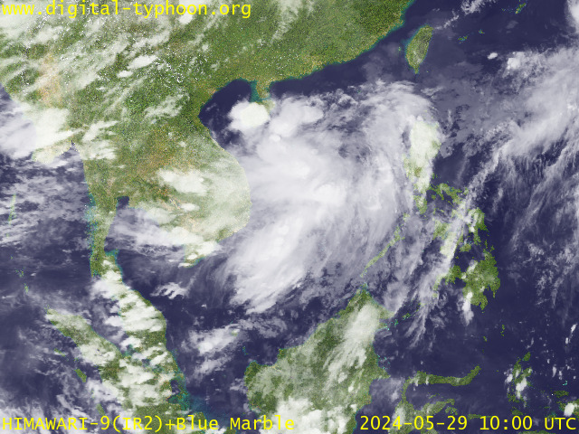
RECENT MTSAT-1R SATELLITE IMAGE:

> Image source: Digital-Typhoon.org (Nat'l. Institute of Informatics) (http://www.digital-typhoon.org )
__________________________________________________________________________________________
NOTES:

> Image source: Digital-Typhoon.
^ - JTWC commentary remarks (for Meteorologists) from their
latest warning.
latest warning.
* - Based on PAGASA's Philippine Storm Warning Signals,
# 4 being the highest. Red letters indicate new areas
being hoisted. For more explanations on these signals,
visit: http://www.typhoon2000.ph/signals.htm
** - Based on the Tropical Cyclone's Wave Height near
its center.
__________________________________________________________________________________________
>> To know the meteorological terminologies and acronyms
used on this update visit the ff:
http://typhoon2000.ph/tcterm.htm
http://www.nhc.noaa.gov/aboutgloss.shtml
http://www.srh.noaa.gov/oun/severewx/glossary.php
http://www.srh.weather.gov/fwd/glossarynation.html
http://www.nhc.noaa.gov/acronyms.shtml
__________________________________________________________________________________________
:: Typhoon2000.com (T2K) Mobile >> Powered by: Synermaxx
Receive the latest storm updates directly to your mobile phones! To know more:
Send T2K HELP to: 2800 (GLOBE & TM) | 216 (SMART & TNT) | 2288 (SUN)
Note: Globe & Smart charges P2.50 per message, while Sun at P2.00.
__________________________________________________________________________________________
For the complete details on TY CIMARON (PAENG)...go visit
our website @:
> http://www.typhoon2000.com
> http://www.maybagyo.com
# 4 being the highest. Red letters indicate new areas
being hoisted. For more explanations on these signals,
visit: http://www.typhoon2
** - Based on the Tropical Cyclone's Wave Height near
its center.
____________
>> To know the meteorological terminologies and acronyms
used on this update visit the ff:
http://typhoon2000.
http://www.nhc.
http://www.srh.
http://www.srh.
http://www.nhc.
____________
:: Typhoon2000.
Receive the latest storm updates directly to your mobile phones! To know more:
Send T2K HELP to: 2800 (GLOBE & TM) | 216 (SMART & TNT) | 2288 (SUN)
Note: Globe & Smart charges P2.50 per message, while Sun at P2.00.
For the complete details on TY CIMARON (PAENG)...go visit
our website @:
> http://www.typhoon2
> http://www.maybagyo
Change settings via the Web (Yahoo! ID required)
Change settings via email: Switch delivery to Daily Digest | Switch format to Traditional
Visit Your Group | Yahoo! Groups Terms of Use | Unsubscribe
SPONSORED LINKS
.
__,_._,___
No comments:
Post a Comment