Tuesday, July 31, 2012

Typhoon SAOLA [GENER] - Update #013


for Tuesday, 31 July 2012 [4:14 PM PhT]

Typhoon2000 (T2K) NEWS (Saturday July 28 2012):

Currently issuing the 6-hrly web, email, SMS & iTyphoon app updates (except 12 Midnight) on SAOLA (GENER).

SAOLA MAX WIND SPEED PER AGENCY:

+ USA (JTWC/1-min avg): 100 km/hr
+ Japan (JMA/10-min avg): 110 km/hr
+ Philippines (PAGASA/10-min avg): 120 km/hr
+ Beijing (NMC/2-min avg): 120 km/hr
+ Taiwan (CWB/10-min avg): 120 km/hr
+ Korea (KMA/10-min avg): 115 km/hr

+ Hong Kong (HKO/10-min avg): 120 km/hr
:: Click here to see Multi-Agency Forecast Tracks


TYPHOON2000 (T2K) TROPICAL CYCLONE UPDATES
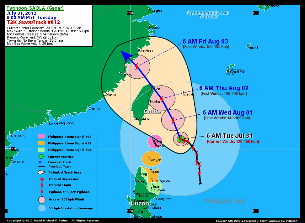
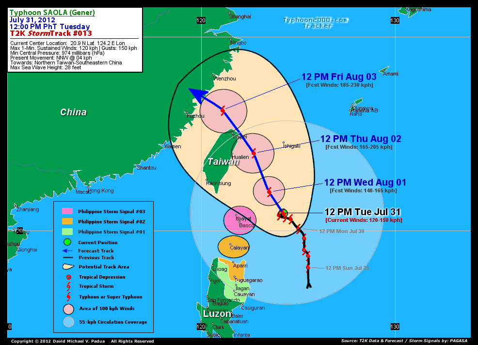
TYPHOON SAOLA (GENER) UPDATE NUMBER 013

12:00 PM PhT (04:00 GMT) Tue 31 July 2012
Sources: T2K Analysis/Dynamical Models/SatFixes
View: T2K TC Update Archives (2004-2012)
Typhoon SAOLA (GENER) continues to wobble to the east of Batanes, may move NNW slowly within the next 12 hours. Rainbands with winds continues to spread and affect Northern Luzon and Eastern Taiwan particularly Batanes, Calayan and Babuyan Islands.

This storm will continue to enhance the Southwest Monsoon (aka. Habagat) across Metro Manila, Southern Tagalog Provinces, Rest of Luzon, Bicol Region, Mindoro, and Western Visayas including Palawan today. Breezy to windy conditions & mostly cloudy conditions w/ occasionally passing rains, thunderstorms & squalls will be expected along the abovementioned areas, especially along the western coast. The seas along the coastal areas facing the West, East and North Philippine Seas will be rough and dangerous.

Residents and visitors along Extreme Northern Luzon, Taiwan and Southeastern China should closely monitor the progress of Saola (Gener).

Do not use this for life or death decision. This advisory is intended for additional information purposes only. Kindly refer to your country's official weather agency for local warnings, advisories & bulletins.


CURRENT STORM INFORMATION

Time/Date: 12:00 PM PhT Tue July 31 2012
Location of Eye: 20.9� N Lat 124.2� E Lon
Distance 1: 233 km ENE of Basco, Batanes
Distance 2: 250 km East of Itbayat, Batanes
Distance 3: 339 km NNE of Santa Ana, Cagayan
Distance 4: 333 km NE of Calayan Island
Distance 5: 389 km NNE of Aparri, Cagayan
Distance 6: 451 km NNE of Tuguegarao City
Distance 7: 400 km South of Ishigaki Jima
Distance 8: 482 km NE of Laoag City
Distance 9: 436 km SE of Hualien, Taiwan
Distance 10: 528 km SSE of Taipei, Taiwan
Distance 11: 773 km NNE of Metro Manila
MaxWinds (1-min avg): 120 kph (65 kts) near the center
Peak Wind Gusts: 150 kph (80 kts)
Present Movement: NNW @ 04 kph (02 kts)
Towards: Northern Taiwan-SE China
CPA [ETA] to Northern Taiwan: Thu-Fri [2PM-2AM PhT]
NOAA 24hr Rainfall Accum (near center): 600 mm (VHigh)
Minimum Central Pressure: 974 millibars (hPa)
Saffir-Simpson Typhoon Scale: Category 1
Size (in Diameter): 1,000 km (540 nm) [Very Large]
Wind Area Distribution (in Knots): Current Wind Profile
Max Sea Wave Height (near center): 28 ft
Possible Storm Surge Height: 4-5 ft [1.2-1.7 m]
T2K StormTracks (for Public): Google Map (Flash) | GIF


3-DAY FORECAST OUTLOOK & ANALYSIS*

SAOLA (GENER) is expected to resume moving slowly NNW for the next 24 to 48 hours with little increase in its forward speed, and will slightly bend NW-ward through 72 hours. On the forecast track, the core of SAOLA will remain over the open sea (North Philippine Sea)...passing well to the ENE of Basco, Batanes today til Wednesday, and will be approaching the coast of Northern & NE Taiwan by Thursday morning. By Thursday evening, SAOLA will be passing very close to Taiwan as it moves out of the Philippine Area of Responsibility (PAR)...and will be just along the coast of Southeastern China on Friday afternoon.

Maximum Sustained Winds (1-min. avg) are near 120 km/hr (65 knots) with higher gusts. More strengthening is forecast during the next 1 to 2 days, and SAOLA is expected to become a Category 2 Typhoon by late Wednesday.

Typhoon Force Winds (118 km/hr or more) extend outward up to 15 kilometers (08 nautical miles) from the center...and Tropical Storm Force Winds (62-117 km/hr) extend outward up to 230 kilometers (125 nautical miles). SAOLA is a large-sized tropical cyclone with a diameter of 1,000 kilometers (540 nautical miles).

The following is the summary of the 3-day forecast outlook on this system:

WEDNESDAY NOON: Gaining more strength as it moves slowly NNW away from the Batanes Islands...about 228 km NE of Basco, Batanes [12PM AUG 01: 22.0N 123.5E @ 140kph].
THURSDAY NOON: Reaches Category 2 strength as it approaches the Northeastern Coast of Taiwan...about 112 km East of Hualien City, Taiwan [12PM AUG 02: 24.0N 122.7E @ 165kph].
FRIDAY NOON: Attains Category 3 status as it approaches the the shores of Southeastern China...about 180 km East of Fuzhou City, China [12PM AUG 03: 26.2N 121.1E @ 185kph].

*Please be reminded that the Forecast Outlook changes every 6 hours, and the Day 3 Forecast Track have an average error of 250 km...while the wind speed forecast error, averages 35 kph per day. Therefore, a turn to the left or right of its future track and changes in its wind speed must be anticipated from time to time.


EFFECTS & HAZARDS SUMMARY

Below is the summary of the storm's parts and its hazards affecting specific areas:

RAGGED EYE - over water (North Philippine Sea). Possible calm and lull conditions (with <20 kph winds) will be expected inside the eye (click here to know more about the EYE).
EYEWALL - over water (North Philippine Sea)...not yet affecting any land areas. Typhoon Conditions with Typhoon Force Winds (>118 kph) will be expected within this wall (click here to know more about the Eyewall).
INNER RAINBANDS - affecting and spreading across Batanes Group of Islands. Tropical Storm Conditions with Tropical Storm Force Winds (62-100 kph) will be expected along these bands.
OUTER RAINBANDS - affecting & spreading across Northern Luzon, Southeastern China and Taiwan including Yaeyama-Ishigaki Islands. Cloudy/Rainy Conditions with moderate to strong winds (<62 kph) will be expected along these bands (click here to know more about Rainbands).
24HR TOTAL RAINFALL ACCUMULATION - from 5 up to 200 mm (low to high rainfall) can be expected along areas affected by the outer & inner rainbands (see above)...with isolated amounts of 201 to 600 mm (very high) along areas near the center of Saola (Gener). (click to open NOAA's eTRaP graphic).
COASTAL STORM SURGE FLOODING - possible 4-5 ft (1.2-1.7 m) above normal tide levels...accompanied by large and dangerous battering waves can be expected along the coastal, inland lakes and beach front areas of Extreme Northern Luzon and Eastern Taiwan. Minimal damage is likely on this type of storm surge. Danger from Rip Currents or Rip Tides can be expected along the rest of the beach-front areas of Eastern Philippines and Southeastern China.
(click here to know more about Storm Surge).


TROPICAL CYCLONE WATCH

Tropical Storm (TS) DAMREY (11W) situated over the far Western Pacific Ocean as it moves rapidly WNW...still threatens Southern Japan. Its center was located about 137 km NNW of Chichi Jima or 380 km NNE of Iwo To (28.4N 139.7E)...with maximum sustained winds of 95 kph and is forecast to move WNW @ 31 kph towards Southern Japan. To view the latest information on this storm kindly click this link.


CURRENT SW MONSOON INTENSITY: MODERATE >> Mostly cloudy skies with occasional showers, rains or thunderstorms w/ squalls will be expected along the following affected areas: METRO MANILA, SOUTHERN TAGALOG PROVINCES, REST OF LUZON, MINDORO, BICOL REGION, and WESTERN VISAYAS. Moderate to strong SW'ly winds (not in excess of 40 kph) will blow across the abovementioned areas.

Important Note: Please keep in mind that the above forecast outlook, effects-hazards, current monsoon intensity, & tropical cyclone watch changes every 6 to 12 hrs!


PAGASA Philippine Storm Warnings Signals

Kindly visit: The official PAGASA Website to view the Signals hoisted


External Links for TY SAOLA (GENER)

PAGASA: Hourly Updates
View NOAA-CIRA's: Latest Full Wind Analysis
JTWC Latest Tracking Chart: wp1012.gif
Multi-Agency Forecast TrackMap: Near Real-Time
TSR Wind Probabilities: Current to 5 Days Ahead
JAXA TRMM Page: Latest Rainrate (in mm/hr)
NASA TRMM Page: Saola's Rainrate Archives (in mm/hr)
Zoomed Satellite Pic: NOAA's Near Real-Time
Wunderground Animation: 6-12 hr. GIF Loop
__________________________________________________________________________________________________

CURRENT NOAA/MTSAT-2 SATELLITE IMAGE:

http://www.ssd.noaa.gov/PS/TROP/floaters/10W/imagery/rgb0.jpg


__________________________________________________________________________________________________

CURRENT TYPHOON2000.COM TRACKING MAP:

http://www.typhoon2000.ph/advisorytrax/2012/gener13.gif
_____________________________________________________________________________

NOTE:

>> To know the meteorological terminologies and acronyms used on this update visit the ff:

   
http://typhoon2000.ph/tcterm.htm  
   
http://www.nhc.noaa.gov/aboutgloss.shtml
    http://www.nhc.noaa.gov/acronyms.shtml
__________________________________________________________________________________________

For the complete details on TS SAOLA (GENER)...go visit our website @:

>
http://www.typhoon2000.com
http://www.maybagyo.com

:: Kindly view our site's disclaimer at: 
   
http://www.typhoon2000.ph/disclaimer.htm
__________________________________________________________________________________________

<<<Typhoon2000.com Mobile >>>
Get the latest SMS Storm Alerts!
For more details: Text T2K TYPHOON to

2800 (Globe/TM) | 216 (Smart/TNT) | 2288 (Sun)
*Only P2.50 (Smart/Globe) / P2.00 (Sun) per msg received.

Click here on how to use this service (in PDF file)
Powered by: Synermaxx Corporation


Copyright © 2012 Typhoon2000.com     All Rights Reserved

__._,_.___
Recent Activity:
.

__,_._,___

Typhoon SAOLA [GENER] - Update #012


for Tuesday, 31 July 2012 [9:12 AM PhT]

Typhoon2000 (T2K) NEWS (Saturday July 28 2012):

Currently issuing the 6-hrly web, email, SMS & iTyphoon app updates (except 12 Midnight) on SAOLA (GENER).

SAOLA MAX WIND SPEED PER AGENCY:

+ USA (JTWC/1-min avg): 100 km/hr
+ Japan (JMA/10-min avg): 100 km/hr
+ Philippines (PAGASA/10-min avg): 120 km/hr
+ Beijing (NMC/2-min avg): 120 km/hr
+ Taiwan (CWB/10-min avg): 105 km/hr
+ Korea (KMA/10-min avg): 115 km/hr

+ Hong Kong (HKO/10-min avg): 120 km/hr
:: Click here to see Multi-Agency Forecast Tracks


TYPHOON2000 (T2K) TROPICAL CYCLONE UPDATES
TYPHOON SAOLA (GENER) UPDATE NUMBER 012

6:00 AM PhT (22:00 GMT) Tue 31 July 2012
Sources: T2K Analysis/Dynamical Models/SatFixes
View: T2K TC Update Archives (2004-2012)
Typhoon SAOLA (GENER) stalls near the east of Batanes Group of Islands. Rainbands with winds continues to spread and lash Northern Luzon and Eastern Taiwan particularly Batanes, Calayan and Babuyan Islands.

This storm will continue to enhance the Southwest Monsoon (aka. Habagat) across Metro Manila, Southern Tagalog Provinces, Rest of Luzon, Bicol Region, Mindoro, and Western Visayas including Palawan today. Breezy to windy conditions & mostly cloudy conditions w/ occasional to sometimes continuous rains, thunderstorms & squalls will be expected along the abovementioned areas, especially along the western coast. The seas along the coastal areas facing the West, East and North Philippine Seas will be rough and dangerous.

Residents and visitors along Extreme Northern Luzon, Taiwan and Southeastern China should closely monitor the progress of Saola (Gener).

Do not use this for life or death decision. This advisory is intended for additional information purposes only. Kindly refer to your country's official weather agency for local warnings, advisories & bulletins.


CURRENT STORM INFORMATION

Time/Date: 6:00 AM PhT Tue July 31 2012
Location of Eye: 20.8� N Lat 124.0� E Lon
Distance 1: 211 km ENE of Basco, Batanes
Distance 2: 229 km East of Itbayat, Batanes
Distance 3: 324 km NNE of Santa Ana, Cagayan
Distance 4: 310 km NE of Calayan Island
Distance 5: 359 km NNE of Aparri, Cagayan
Distance 6: 430 km NNE of Tuguegarao City
Distance 7: 412 km South of Ishigaki Jima
Distance 8: 459 km NE of Laoag City
Distance 9: 433 km SE of Hualien, Taiwan
Distance 10: 528 km SSE of Taipei, Taiwan
Distance 11: 765 km NNE of Metro Manila
MaxWinds (1-min avg): 120 kph (65 kts) near the center
Peak Wind Gusts: 150 kph (80 kts)
Present Movement: NW @ 05 kph (03 kts)
Towards: Northern Taiwan-SE China
CPA [ETA] to Northern Taiwan: Thursday [6AM-6PM PhT]
NOAA 24hr Rainfall Accum (near center): 330 mm (High)
Minimum Central Pressure: 974 millibars (hPa)
Saffir-Simpson Typhoon Scale: Category 1
Size (in Diameter): 1,000 km (540 nm) [Very Large]
Wind Area Distribution (in Knots): Current Wind Profile
Max Sea Wave Height (near center): 28 ft
Possible Storm Surge Height: 4-5 ft [1.2-1.7 m]
T2K StormTracks (for Public): Google Map (Flash) | GIF


3-DAY FORECAST OUTLOOK & ANALYSIS*

SAOLA (GENER) is expected to resume moving slowly NNW for the next 24 to 48 hours with a gradual increase in its forward speed, and will slightly bend NW-ward after 72 hours. On the forecast track, the core of SAOLA will remain over the open sea (North Philippine Sea)...passing well to the ENE of Basco, Batanes today til Wednesday, and will be approaching the coast of Northern & NE Taiwan by late Wednesday evening. By Thursday morning, SAOLA will be passing very close to Taiwan as it moves out of the Philippine Area of Responsibility (PAR)...and will be just along the coast of Southeastern China early Friday morning.

Maximum Sustained Winds (1-min. avg) are near 120 km/hr (65 knots) with higher gusts. More strengthening is forecast during the next 1 to 2 days, and SAOLA is expected to become a Category 2 Typhoon on Wednesday.

Typhoon Force Winds (118 km/hr or more) extend outward up to 15 kilometers (08 nautical miles) from the center...and Tropical Storm Force Winds (62-117 km/hr) extend outward up to 130 kilometers (70 nautical miles). SAOLA is a large-sized tropical cyclone with a diameter of 1,000 kilometers (540 nautical miles).

The following is the summary of the 3-day forecast outlook on this system:

WEDNESDAY MORNING: Gaining more strength as it moves away slowly NNW towards Northern Taiwan...about 247 km NE of Basco, Batanes [6AM AUG 01: 22.3N 123.4E @ 140kph].
THURSDAY MORNING: Reaches Category 2 strength as it approaches the Northeastern Coast of Taiwan...about 91 km East of Hualien City, Taiwan [6AM AUG 02: 24.0N 122.5E @ 165kph].
FRIDAY MORNING: Just along the shores of Southeastern China...weakens to Category 1 as it prepares to make landfall...about 132 km ENE of Fuzhou City, China [6AM AUG 03: 26.6N 120.5E @ 150kph].

*Please be reminded that the Forecast Outlook changes every 6 hours, and the Day 3 Forecast Track have an average error of 250 km...while the wind speed forecast error, averages 35 kph per day. Therefore, a turn to the left or right of its future track and changes in its wind speed must be anticipated from time to time.


EFFECTS & HAZARDS SUMMARY

Below is the summary of the storm's parts and its hazards affecting specific areas:

BANDING EYE - over water (North Philippine Sea). Possible calm and lull conditions (with <20 kph winds) will be expected inside the eye (click here to know more about the EYE).
EYEWALL - over water (North Philippine Sea)...not yet affecting any land areas. Typhoon Conditions with Typhoon Force Winds (>118 kph) will be expected within this wall (click here to know more about the Eyewall).
INNER RAINBANDS - affecting and spreading across Batanes Group of Islands. Tropical Storm Conditions with Tropical Storm Force Winds (62-100 kph) will be expected along these bands.
OUTER RAINBANDS - affecting & spreading across Northern Luzon, Southeastern China and Taiwan including Yaeyama-Ishigaki Islands. Cloudy/Rainy Conditions with moderate to strong winds (<62 kph) will be expected along these bands (click here to know more about Rainbands).
24HR TOTAL RAINFALL ACCUMULATION - from 5 up to 200 mm (low to high rainfall) can be expected along areas affected by the outer & inner rainbands (see above)...with isolated amounts of 201 to 330 mm (high) along areas near the center of Saola (Gener). (click to open NOAA's eTRaP graphic).
COASTAL STORM SURGE FLOODING - possible 4-5 ft (1.2-1.7 m) above normal tide levels...accompanied by large and dangerous battering waves can be expected along the coastal, inland lakes and beach front areas of Extreme Northern Luzon and Eastern Taiwan. Minimal damage is likely on this type of storm surge. Danger from Rip Currents or Rip Tides can be expected along the rest of the beach-front areas of Eastern Philippines and Southeastern China.
(click here to know more about Storm Surge).


TROPICAL CYCLONE WATCH

Tropical Storm (TS) DAMREY (11W) still over the far Western Pacific Ocean as it moves rapidly WNW...threatens Southern Japan. Its center was located about 137 km NNW of Chichi Jima or 380 km NNE of Iwo To (28.2N 141.7E)...with maximum sustained winds of 100 kph and is forecast to move NW @ 31 kph towards the Southern Japan. To view the latest information on this storm kindly click this link.


CURRENT SW MONSOON INTENSITY: MODERATE >> Mostly cloudy skies with occasional showers, rains or thunderstorms w/ squalls will be expected along the following affected areas: METRO MANILA, SOUTHERN TAGALOG PROVINCES, REST OF LUZON, MINDORO, BICOL REGION, WESTERN VISAYAS and PALAWAN. Moderate to strong SW'ly winds (not in excess of 40 kph) will blow across the abovementioned areas.

Important Note: Please keep in mind that the above forecast outlook, effects-hazards, current monsoon intensity, & tropical cyclone watch changes every 6 to 12 hrs!


PAGASA Philippine Storm Warnings Signals

Kindly visit: The official PAGASA Website to view the Signals hoisted


External Links for TY SAOLA (GENER)

PAGASA: Hourly Updates
View NOAA-CIRA's: Latest Full Wind Analysis
JTWC Latest Tracking Chart: wp1012.gif
Multi-Agency Forecast TrackMap: Near Real-Time
TSR Wind Probabilities: Current to 5 Days Ahead
JAXA TRMM Page: Latest Rainrate (in mm/hr)
NASA TRMM Page: Saola's Rainrate Archives (in mm/hr)
Zoomed Satellite Pic: NOAA's Near Real-Time
Wunderground Animation: 6-12 hr. GIF Loop


Notes: T2K translates all technical data terms into layman's form for public understanding. Do not use this for life/death decision, kindly refer to your country's official warnings/bulletins. This site is intended for additional information purposes only. Local times are based on Philippine / Hong Kong / Shanghai Standard Times. Maximum Sustained Winds are based on either 1-minute average (JTWC) or 10-minute average (JMA). Pressure Estimates by: NRL & RSMC-Tokyo Typhoon Centre (JMA). Max Wave Height by: NPMOC (USA). Live Naga City weather conditions (if available) taken from T2K`s new DAVIS VANTAGE VUE Digital Weather Station.

THE NEXT UPDATE WILL BE ISSUED BETWEEN 11:30 AM TO 1:30 PM (03:30-05:30 GMT) TODAY.
__________________________________________________________________________________________________

CURRENT NOAA/MTSAT-2 SATELLITE IMAGE:

http://www.ssd.noaa.gov/PS/TROP/floaters/10W/imagery/rgb0.jpg


__________________________________________________________________________________________________

CURRENT TYPHOON2000.COM TRACKING MAP:

http://www.typhoon2000.ph/advisorytrax/2012/gener12.gif
_____________________________________________________________________________

NOTE:

>> To know the meteorological terminologies and acronyms used on this update visit the ff:

   
http://typhoon2000.ph/tcterm.htm  
   
http://www.nhc.noaa.gov/aboutgloss.shtml
    http://www.nhc.noaa.gov/acronyms.shtml
__________________________________________________________________________________________

For the complete details on TS SAOLA (GENER)...go visit our website @:

>
http://www.typhoon2000.com
http://www.maybagyo.com

:: Kindly view our site's disclaimer at: 
   
http://www.typhoon2000.ph/disclaimer.htm
__________________________________________________________________________________________

<<<Typhoon2000.com Mobile >>>
Get the latest SMS Storm Alerts!
For more details: Text T2K TYPHOON to

2800 (Globe/TM) | 216 (Smart/TNT) | 2288 (Sun)
*Only P2.50 (Smart/Globe) / P2.00 (Sun) per msg received.

Click here on how to use this service (in PDF file)
Powered by: Synermaxx Corporation


Copyright © 2012 Typhoon2000.com     All Rights Reserved

__._,_.___
Recent Activity:
.

__,_._,___

Monday, July 30, 2012

Typhoon SAOLA [GENER] - Update #011


for Monday, 30 July 2012 [7:33 PM PhT]

Typhoon2000 (T2K) NEWS (Saturday July 28 2012):

Currently issuing the 6-hrly web, email, SMS & iTyphoon app updates (except 12 Midnight) on SAOLA (GENER).

SAOLA MAX WIND SPEED PER AGENCY:

+ USA (JTWC/1-min avg): 120 km/hr
+ Japan (JMA/10-min avg): 100 km/hr
+ Philippines (PAGASA/10-min avg): 120 km/hr
+ Beijing (NMC/2-min avg): 120 km/hr
+ Taiwan (CWB/10-min avg): 105 km/hr
+ Korea (KMA/10-min avg): 110 km/hr

+ Hong Kong (HKO/10-min avg): 110 km/hr
:: Click here to see Multi-Agency Forecast Tracks


TYPHOON2000 (T2K) TROPICAL CYCLONE UPDATES
TYPHOON SAOLA (GENER) UPDATE NUMBER 011

6:00 PM PhT (10:00 GMT) Mon 30 July 2012
Sources: T2K Analysis/Dynamical Models/SatFixes
View: T2K TC Update Archives (2004-2012)
SAOLA (GENER) has strengthened into a Typhoon as it drifts northwestward...now passing east of Batanes Islands while heading dangerously towards Taiwan. Rainbands continues to spread across Northern Luzon and Eastern Taiwan.

This storm will continue to enhance the Southwest Monsoon (aka. Habagat) across Metro Manila, Southern Tagalog Provinces, Rest of Luzon, Bicol Region, Mindoro, and Visayas today. Breezy to very windy conditions & mostly cloudy conditions w/ occasional to sometimes continuous rains, thunderstorms & squalls will be expected along the abovementioned areas, especially along the western coast. The seas along the coastal areas facing the West, East and North Philippine Seas will be rough and dangerous.

Residents and visitors along Extreme Northern Luzon, Taiwan and Southeastern China should closely monitor the progress of Saola (Gener).

Do not use this for life or death decision. This advisory is intended for additional information purposes only. Kindly refer to your country's official weather agency for local warnings, advisories & bulletins.


CURRENT STORM INFORMATION

Time/Date: 6:00 PM PhT Mon July 30 2012
Location of Eye: 20.6� N Lat 124.6� E Lon
Distance 1: 271 km East of Basco, Batanes
Distance 2: 292 km East of Itbayat, Batanes
Distance 3: 343 km NE of Santa Ana, Cagayan
Distance 4: 355 km ENE of Calayan Island
Distance 5: 390 km NE of Aparri, Cagayan
Distance 6: 452 km NE of Tuguegarao City
Distance 7: 436 km SSE of Ishigaki Jima
Distance 8: 497 km NE of Laoag City
Distance 9: 488 km SE of Hualien, Taiwan
Distance 10: 578 km SSE of Taipei, Taiwan
Distance 11: 773 km NNE of Metro Manila
MaxWinds (1-min avg): 120 kph (65 kts) near the center
Peak Wind Gusts: 150 kph (80 kts)
Present Movement: NW @ 11 kph (06 kts)
Towards: Northern Taiwan-SE China
CPA [ETA] to Northern Taiwan: Thursday [6AM-6PM PhT]
NOAA 24hr Rainfall Accum (near center): 420 mm (VHigh)
Minimum Central Pressure: 974 millibars (hPa)
Saffir-Simpson Typhoon Scale: Category 1
Size (in Diameter): 890 km (480 nm) [Large]
Wind Area Distribution (in Knots): Current Wind Profile
Max Sea Wave Height (near center): 27 ft
Possible Storm Surge Height: 4-5 ft [1.2-1.7 m]
T2K StormTracks (for Public): Google Map (Flash) | GIF


3-DAY FORECAST OUTLOOK & ANALYSIS*

SAOLA (GENER) is expected to resume moving NNW for the next 24 to 48 hours with a gradual decrease in its forward speed, and will slightly bend NW-ward after 72 hours. On the forecast track, the core of SAOLA will remain over the open sea (North Philippine Sea)...passing well to the ENE of Basco, Batanes tonight til Tuesday, and approaching the coast of Northeastern Taiwan by Wednesday evening. By midday Thursday, SAOLA will be out of the Philippine Area of Responsibility (PAR) as it passes very close to the coast of Northeastern Taiwan

Maximum Sustained Winds (1-min. avg) are near 120 km/hr (65 knots) with higher gusts. More strengthening is forecast during the next 3 days, and SAOLA is expected to become a Category 2 Typhoon by Tuesday evening.

Typhoon Force Winds (118 km/hr or more) extend outward up to 35 kilometers (20 nautical miles) from the center...and Tropical Storm Force Winds (62-117 km/hr) extend outward up to 130 kilometers (70 nautical miles). SAOLA is a large-sized tropical cyclone with a diameter of 890 kilometers (480 nautical miles).

The following is the summary of the 3-day forecast outlook on this system:

TUESDAY EVENING: Approaching Category 2 strength as it moves slowly NNW...about 253 km NE of Basco, Batanes [6PM JUL 31: 21.8N 124.0E @ 150kph].
WEDNESDAY EVENING: Reaches Category 3 strength as it approaches the Northeastern Coast of Taiwan...about 185 km ESE of Hualien City, Taiwan [6PM AUG 01: 23.4N 123.3E @ 195kph].
THURSDAY EVENING: Weakens to Category 2 as it exits the Philippine Area of Responsibility (PAR)...about 78 km ENE of Taipei, Taiwan [6PM AUG 02: 25.7N 121.7E @ 165kph].

*Please be reminded that the Forecast Outlook changes every 6 hours, and the Day 3 Forecast Track have an average error of 250 km...while the wind speed forecast error, averages 35 kph per day. Therefore, a turn to the left or right of its future track and changes in its wind speed must be anticipated from time to time.


EFFECTS & HAZARDS SUMMARY

Below is the summary of the storm's parts and its hazards affecting specific areas:

RAGGED EYE - over water (North Philippine Sea). Possible calm and lull conditions (with <20 kph winds) will be expected inside the eye (click here to know more about the EYE).
EYEWALL - over water (North Philippine Sea)...not yet affecting any land areas. Typhoon Conditions with Typhoon Force Winds (>118 kph) will be expected within this wall (click here to know more about the Eyewall).
INNER RAINBANDS - over water (North Philippine Sea)...not yet affecting any land areas, but its westernmost part is slightly affecting the Batanes Group of Islands. Tropical Storm Conditions with Tropical Storm Force Winds (62-100 kph) will be expected along these bands.
OUTER RAINBANDS - affecting & spreading across Northern Luzon, Batanes-Babuyan-Calayan Group of Islands and Taiwan including Yaeyama-Ishigaki Islands. Cloudy/Rainy Conditions with moderate to strong winds (<62 kph) will be expected along these bands (click here to know more about Rainbands).
24HR TOTAL RAINFALL ACCUMULATION - from 5 up to 200 mm (low to high rainfall) can be expected along areas affected by the outer & inner rainbands (see above)...with isolated amounts of 201 to 420 mm (high to very high) along areas near the center of Saola (Gener). (click to open NOAA's eTRaP graphic).
COASTAL STORM SURGE FLOODING - possible 4-5 ft (1.2-1.7 m) above normal tide levels...accompanied by large and dangerous battering waves can be expected along the coastal, inland lakes and beach front areas of Extreme Northern Luzon and Eastern Taiwan. Minimal damage is likely on this type of storm surge. Danger from Rip Currents or Rip Tides can be expected along the rest of the beach-front areas of Eastern Philippines and Southeastern China.
(click here to know more about Storm Surge).


TROPICAL CYCLONE WATCH

Tropical Storm (TS) DAMREY (11W) still over the far Western Pacific Ocean as it moves very slowly...still no threat to land. Its center was located about 344 km SE of Chichi Jima or 355 km ENE of Iwo To (26.1N 144.2E)...with maximum sustained winds of 85 kph and is forecast to move WNW slowly towards the Southern Islands of Japan. To view the latest information on this storm kindly click this link.


CURRENT SW MONSOON INTENSITY: STRONG >> Cloudy skies with occasional to widespread showers, rains or thunderstorms w/ squalls will be expected along the following affected areas: METRO MANILA, SOUTHERN TAGALOG PROVINCES, REST OF LUZON, MINDORO, BICOL REGION, VISAYAS and PALAWAN. Moderate to strong SW'ly winds (not in excess of 65 kph) will blow across the abovementioned areas.

Important Note: Please keep in mind that the above forecast outlook, effects-hazards, current monsoon intensity, & tropical cyclone watch changes every 6 to 12 hrs!


PAGASA Philippine Storm Warnings Signals

Kindly visit: The official PAGASA Website to view the Signals hoisted


External Links for TY SAOLA (GENER)

PAGASA: Hourly Updates
View NOAA-CIRA's: Latest Full Wind Analysis
JTWC Latest Tracking Chart: wp1012.gif
Multi-Agency Forecast TrackMap: Near Real-Time
TSR Wind Probabilities: Current to 5 Days Ahead
JAXA TRMM Page: Latest Rainrate (in mm/hr)
NASA TRMM Page: Saola's Rainrate Archives (in mm/hr)
Zoomed Satellite Pic: NOAA's Near Real-Time
Wunderground Animation: 6-12 hr. GIF Loop
__________________________________________________________________________________________________

CURRENT NOAA/MTSAT-2 SATELLITE IMAGE:

http://www.ssd.noaa.gov/PS/TROP/floaters/10W/imagery/rgb0.jpg


__________________________________________________________________________________________________

CURRENT TYPHOON2000.COM TRACKING MAP:

http://www.typhoon2000.ph/advisorytrax/2012/gener11.gif
_____________________________________________________________________________

NOTE:

>> To know the meteorological terminologies and acronyms used on this update visit the ff:

   
http://typhoon2000.ph/tcterm.htm  
   
http://www.nhc.noaa.gov/aboutgloss.shtml
    http://www.nhc.noaa.gov/acronyms.shtml
__________________________________________________________________________________________

For the complete details on TS SAOLA (GENER)...go visit our website @:

>
http://www.typhoon2000.com
http://www.maybagyo.com

:: Kindly view our site's disclaimer at: 
   
http://www.typhoon2000.ph/disclaimer.htm
__________________________________________________________________________________________

<<<Typhoon2000.com Mobile >>>
Get the latest SMS Storm Alerts!
For more details: Text T2K TYPHOON to

2800 (Globe/TM) | 216 (Smart/TNT) | 2288 (Sun)
*Only P2.50 (Smart/Globe) / P2.00 (Sun) per msg received.

Click here on how to use this service (in PDF file)
Powered by: Synermaxx Corporation


Copyright © 2012 Typhoon2000.com     All Rights Reserved

__._,_.___
Recent Activity:
.

__,_._,___